Oakland to Chicago – Great Basin National Park to
Blanding, UT
Denis Kertz, ©2001
Day 15: 9/15/2001,
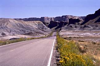
Saturday - Great Basin NP, NV to Milford, UT (pop 1,107) [92.1]
I got up
shortly after 7:00, in no hurry because the café in Baker didn’t open for
breakfast until 8:30 and I needed breakfast because I was out of food. Fortunately, it was the weekend, the only
time the café served breakfast during their winter hour period.
It was
an easy 8-mile downhill cruise to Baker.
I got at the café just after 8:30 and ordered an omelet since they
didn’t offer pancakes. Shortly after
that something happened with the electrical system and they had to turn some
folks away since they were unable to cook.
Later a retired couple from Santa Rosa, Jerry and Mary Ann, showed up
and ordered non-cooking items. They
asked about my trip and were interested, as they had done some supported
touring in Europe. An interesting
conversation that prolonged my stay.
So I
didn’t get off until 9:30, which was essentially 10:30 since the time zone
changed as I entered Utah in a few miles where the road also changed to Utah
21. If Nevada US 50 was the Loneliest
Road in America then Utah 21 was beyond lonely as it had much less
traffic. 21 was also a bit rougher road
with some coarse gravel asphalt. It
also didn’t have rumble strips so its entire shoulder was useful although it
wasn’t needed with the light traffic.
21 went
down the valley and for a while the west side of the road paralleled a ranch
with a fair number of cattle. Around
noon, I road through the Mormon Gap. I
expected a following descent but the road kept an easy gradual climb to Halfway
Summit at 6,155’ although I wasn’t sure what it was halfway to. It certainly wasn’t halfway between Baker
and Milford.
 After a nice descent I started the
climb to Wah Wah Summit at 6,439’, about a 1,200’ climb. This was pretty easy too and I began
believing my conditioning was kicking in.
My past experience has been the first two weeks of touring saw the most
improvement in conditioning with some more improvement in the third week and I
was now two weeks in the tour. The
final part of this climb was scenic, between two mountains with yellow
grasslands and dotted bushy trees.
After a nice descent I started the
climb to Wah Wah Summit at 6,439’, about a 1,200’ climb. This was pretty easy too and I began
believing my conditioning was kicking in.
My past experience has been the first two weeks of touring saw the most
improvement in conditioning with some more improvement in the third week and I
was now two weeks in the tour. The
final part of this climb was scenic, between two mountains with yellow
grasslands and dotted bushy trees.
At the
pass I took a break shortly after 3:00, thinking I was now going to coast into
Milford. When I descended I had a great
view except something was wrong. The
road went across the basin and up into the mountains. Then I realized I had misread the route profile. The last and highest climb, 1,450’, remained
and I was picking up a headwind. As I
started the long climb I heard some thunder rumbling as clouds were gathering
over the mountains. It was a long climb
and my legs were tired so I had to go slow.
So much for my conditioning. All
I could see was the road going straight up the mountains but then it began a
90° left turn. Usually I just grind out
these climbs and get it over with but I had to take a quick break about half
way up.
Starting
up again, my legs were dead but they warmed up a bit. Further on I thought I was getting close to the summit but had to
take another quick stop. As the 90°
turn began it looked like I could be close to the top but I remembered my map
showing that it had to turn right again before the summit. I heard a few more rumbles off to my right
and finally reached the summit. I
drained the last of my water bottles and could have used more water but I was
too tired to tap my water reservoir in my water bladder that was buried under
my tent and sleeping bag. It was now
about 5:45.
From the
top it looked like I might be able to cruise/coast the 14 miles to
Milford. Initially, I coasted at about
20 mph but my neck and shoulder were cramped from climbing so I couldn’t really
enjoy the descent. Mercifully the wind
seemed to be a benign crosswind. I did
have to do some easy pedaling towards the end but that probably wasn’t bad for
my toasted legs.
Then
about 2 miles from town I felt a few sprinkles and the crosswind really picked
up. I picked up my pedaling, hoping to
make town before all hell broke loose.
I pulled into town and stopped at a food mart for refreshments, downing
a 32 oz Gatorade in record time. I had
planned to check out the RV Park but the weather and rapidly approaching dark
nixed that idea. The only motel in town
was right behind the food mart. It was
a bit expensive at $38 but I didn’t have much choice and the room was pretty
nice. I ate Chinese food at the
adjoining restaurant and called it a night.
Although
I entered a new state today that looked much the same as the previous one, I
did notice one difference.
Periodically, road signs warned about cattle presence with a picture of
a cow in a diamond shaped sign. In
Nevada these signs were usually peppered with bullet holes but they were
relatively untouched in Utah.
Day 16: 9/16/2001, Sunday
- Milford, UT to Cedar City, UT (pop 13,443) [58.1]
I got up
at 7:30 but that was Mountain Time, which I wasn’t adjusted to yet. I walked the block to Hong Kong Café that I
was told was the only place open for breakfast and it was actually open 24
hours. My short walk along the main
street suggested Milford had seen better days.
The nice brick Milford Hotel was boarded up and three eating establishments
were closed. That made it seem strange
that a café was open around the clock.
Later I realized the reason must be because the Union Pacific terminal
was nearby and probably supported the 24 hours.
I had
oatmeal and pancakes, which was a big breakfast. The oatmeal was a large bowl and the pancakes were not
miniatures. I wondered if this
breakfast would have gotten me through yesterday’s ordeal in better shape.
After
breakfast I walked back to the motel, packed up, and was off by 9:00. My AC map took me to Minersville via the
back way on Country Road 1002. This was
a little longer than taking 21 but nice and quiet. Most of the way was farming area with the rolling irrigation
system in use.
In
Minersville, after 16 miles, I stopped at a food mart for refreshments and
picked up a sandwich. Then I took off
on 130, continuing the long climb that began just outside Milford but at a
slightly higher grade. Then the grade
increased and snaked up the hill, never getting really steep except for one short
section. Near the top the grade
actually eased and I reached the top after about 26 miles, almost half of the
day’s trip.
 At that point I wanted to take a
break but a threatening cloud hung overhead so I decided it was best to get off
the top. A little later I stopped and
devoured my sandwich as I heard some thunder rumblings. As I started again I felt raindrops and
hoped it wouldn’t develop into real rain.
At that point I wanted to take a
break but a threatening cloud hung overhead so I decided it was best to get off
the top. A little later I stopped and
devoured my sandwich as I heard some thunder rumblings. As I started again I felt raindrops and
hoped it wouldn’t develop into real rain.
The
descent was modest and as the grade eased I picked up my enemy - the
headwind. What should have been a
fairly easy run into Cedar City became a chore. And for a while the dark cloud seemed to be following me. I wondered what I had done to deserve this.
Off in
the distance I could see what must be Cedar City and was frustrated with my
slow pace due mostly to the headwind although there was a gradual climb that
contributed as well. As I neared Cedar
City the climb increased somewhat making progress even slower.
Finally,
I reached the outskirts of Cedar City and stopped at a food mart for refreshments. I continued past the I80 intersection on
into town. When I got to Center St I
turned west and found the library and bike shop but they were both closed as I
expected on a Sunday. So I retreated to
the main street looking for inexpensive motels. I found one for $27 that was somewhat of a dive but I took it.
After
cleaning up I ate at a Pizza Hut and got some information on the upcoming
5,000’ climb to Cedar Breaks. I was
uncertain how to attack this climb. I
considered resting a day and then attacking.
However, there was a campsite about halfway up so I decided I might want
to do half of the climb tomorrow and the remainder the next day. Much would depend on how my body and mind
felt in the morning, after two fairly hard days.
Day 17: 9/17/2001, Monday
- Cedar City, UT to Cedar Breaks, UT [32.6]
I slept
well and didn’t get up until 7:30. I
walked to breakfast and had an omelet and pancakes. Later, I discovered I should have walked further and I could have
had a breakfast buffet for $4.50.
After
breakfast I walked to the library and got there about 9:15. I was able to get on the Internet right away
and take care of my email. Back at the
motel I took my time since I didn’t have to be out until 11:00. My legs felt really tired when I got up so I
was in no rush.
I did a
little shopping and decided to check on a campground halfway to Cedar
Breaks. That’s when I got the bad news
they were shutting off the water in the campground today. Given that I figured I’d better learn more
about the water situation so I looked up the USFS. It was near where I would take 14 so I stopped at the office and
found it locked. Checking the back of
the office building I found a sign saying they had moved. So I had to bike a couple of miles north of
town. There I learned that Cedar Breaks
itself had water. I asked about the
stream on my map that paralleled 14 up the canyon. The receptionist said she had never seen it dry so I figured I
was OK since I had a water filter.
I picked
up a few more grocery items to last me two days and then headed back towards
the southern end of town. I stopped at
a Subway for a sandwich. It was
noontime with a fair line but an efficient group of four workers were doing a
good job filling orders. That was until
the two women just ahead of me dumped about 6 orders on them, which always
happens when you are in a hurry. When
my time came, I ordered a foot long sub, ate half, and saved the other half for
later.
Finally,
at 1:00 I left with already 9 miles on my bike from messing around. The route went up a canyon that was quite
scenic. An early sign warned of an 8%
grade the next 15 miles. I also saw
water in the stream along the road so I was happy.
Initially,
the first 7 miles weren’t that steep and I was doing about 6 mph with problem
and felt fine. Then the road grade
increased and for 4-5 miles I was in my two lowest gears but still feeling
OK. Along the way a police car with
flashing lights passed. A little later
I found it at a scene with a boat laying along side the road in the ditch. I couldn’t imagine how the boat could have
slid off a trailer while heading downhill.
There was also quite a bit of traffic and a lot of it was cement trucks. However, due to the grade of the road the
trucks were going slow and posed little danger even without any real shoulder.
 I took a short break around 3:00 at
about the halfway point to Cedar Breaks in fine cool weather. Shortly after I started again I saw the sign
for Cedar Canyon Campground to the left.
It was a bit before the actual turnoff appeared. Then I got to thinking that I was feeling
good, I was halfway to Cedar Breaks, and it was only mid-afternoon so I just
continued.
I took a short break around 3:00 at
about the halfway point to Cedar Breaks in fine cool weather. Shortly after I started again I saw the sign
for Cedar Canyon Campground to the left.
It was a bit before the actual turnoff appeared. Then I got to thinking that I was feeling
good, I was halfway to Cedar Breaks, and it was only mid-afternoon so I just
continued.
It was
steep at this point but there were some nice views. At one point a vista opened up on a bowl area with patches of
changing fall colors. A notch in the
bowl revealed some spectacular land formations in the distance that was Mt.
Zion National Park. A gorgeous view.
Shortly
the climb eased and then I started a gradual downhill into a big meadow area. Here I had to give up the run out to turn on
148 to head to Cedar Breaks. I started
some more climbing but the traffic that was fairly heavy on 14 dropped off to
almost nothing. It was only a few miles
and I entered Cedar Breaks National Monument.
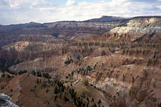
A mile further I stopped at the visitor center, paid the $3 fee, and saw
the incredible natural rock amphitheater that plunged 2,500’ and was more than
3 miles in diameter. At one time this
was called the Circle of Painted Cliffs.
Certainly worth climbing 5,000’.
I
continued a ½ mile to the campground and set up for $10. An uncertain day turned into a big surprise
when my body responded with only needing a ½ day to make the 5,000’ climb after
feeling so tired the previous two days.
Day 18: 9/18/2001, Tuesday
- Cedar Breaks, UT to Bryce Canyon NP, UT [64.1]
I got up
at 7:30 and ate a good breakfast. By
9:00 I was packed and on the road in my tights and jacket on a cool
morning. The road followed the rim of
the Cedar Breaks amphitheatre for about 4 miles with a couple of scenic
turnouts for views of the breaks from different angles. The road was up and down and my legs felt it
every time it was up.
After 4
miles I turned right on to 143 to take me downhill to Panguitch. On some of the initial descents I was
quickly in the 30 mph range and hit 40 mph once but I was a little careful
since the road was a bit rough. At the
high elevations where I started at over 10,000’ the fall colors were in almost
their full glory. So it was a scenic
descent with the aspen mixed with cedars in the meadows. The temperature was cool and crisp as the
sunlight flitted through the trees along the road. An almost perfect descent setting.
At
Panguitch Lakes I stopped for a quick break and continued to Panguitch. It was 13 miles to the lake and another 17
miles to town. The road got flatter as
it neared town and required more pedaling.
Except for the very last mile or two it was a quick descent. Panguitch sat in a valley with the mountains
rising again in the distance.
In town
I stopped for a sandwich at an Arby’s attached to a food mart. After eating I wanted to get some chain
cleaner fluid so I inquired about the bike shop and was disappointed to learn
that it had shut down about a year before.
I headed
out of town about 1:00 on 89. There was
a lot of traffic but the very wide shoulder made that no problem. It was easy pedaling for 7 miles until I
turned east on 12 towards Bryce Canyon.
I started climbing moderately and entered the picturesque Red
Canyon. I stopped at its visitor center
and met another touring cyclist who was with a group on a two-week tour from
St. George to Grand Canyon, Mt. Zion, and Bryce Canyon. The receptionist at the visitor center gave
me some idea of what to expect in Bryce Canyon. She said it would be similar to what I saw in Cedar Breaks and
Red Canyon so she didn’t necessarily recommend taking the 17-mile dead end road
through the park. She recommended
taking the first left, Fairyland Point, just before the park entrance booth to
get a good view.
 I continued on and started climbing
more seriously. After several miles of
climbing the road reached a plateau and it was easy sailing the rest of the way
with some tailwind. At the turnoff on
63, I immediately started seeing a series of signs for Ruby’s Inn, somewhat
reminiscent of seeing signs for Wall Drugs in South Dakota. I stopped and checked out the grocery store
and found my favorite ice cream cookie sandwich.
I continued on and started climbing
more seriously. After several miles of
climbing the road reached a plateau and it was easy sailing the rest of the way
with some tailwind. At the turnoff on
63, I immediately started seeing a series of signs for Ruby’s Inn, somewhat
reminiscent of seeing signs for Wall Drugs in South Dakota. I stopped and checked out the grocery store
and found my favorite ice cream cookie sandwich.
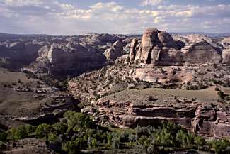
Continuing
towards the park I found the road to Fairyland Point and found a spectacular
view. In contrast to Cedar Breaks,
which was wide and deep, Fairyland was more intimate, being smaller and not as
deep. In addition to providing views of
numerous spires and hoo doos it afforded long distance views of the breaks many
miles to the east. It was hard deciding
what pictures to take.
After my
senses were saturated, I returned to Ruby’s Inn and secured a campsite at their
campground for $17. It was a combined
RV Park and campground but they did a decent job of segregating campsites from
RV sites. I set up camp and walked “to
town” for food, at most ¼ mile. The
restaurant looked packed so I nuked a couple of burritos from their grocery
store.
All in
all a relatively easy day with some exceptional scenery starting and ending the
day. My only regret was not linking up
with the touring group that camped somewhere in the park.
Day 19: 9/19/2001,
Wednesday - Bryce Canyon NP, UT to Calf Creek CG, UT [65.5]
I got up
just before 7:00 (sunrise was 7:14) and started to pack. I wanted to get breakfast before the crowds
hit. I cycled the short distance to
town and saw a sign showing the temperature was 36° at 7:30. The maitre d’ set me at a table and
mentioned a cycling group was on the other side. As I was getting settled he talked to the cycling group and got
me invited to sit with them. They were
a group of 7 with 2 tour guides on a supported week tour of Bryce Canyon and
Mt. Zion from St. George. One couple was
from San Diego, another Atlanta, and a single guy from Philadelphia but I didn’t
catch where the third couple was from.
We had an interesting conversation, especially with the Atlanta
couple. They were retired BellSouth
employees living in Norcross. Today the
group was on their way to Mt. Zion, driving part of the way before riding the
rest of the way since it was over 100 miles.
It was an enjoyable breakfast but I stayed on after they finished to get
my money’s worth from the buffet.
The nice
thing about leaving Bryce Canyon was I left the zoo-like atmosphere
behind. Ruby’s Inn was just too
commercial for my tastes even if the breakfast buffet was great. Then when I got back on 12 heading east, the
traffic was considerably less than yesterday as I left the main attraction.
It was
downhill the first 16 miles to Henrieville.
The descent was into a valley with farms and irrigation equipment in the
fields. Two very small towns, Tropic
and Cannonville, showed the effects of being close to a popular national park
as they had motels and restaurants beyond their means.
After
Henrieville, the road climbed about 1,400’ but it was almost unnoticeable. I guess after Monday’s 5,000’ climb nothing
seemed big. That is until the last mile
of the climb when the road went sky high on a very steep climb. I was thankful it was a little less than a
mile long although the climb did reward with a nice view of the Table Cliff
Plateau. Even better was the 36 miles
to Escalante that was almost all downhill.
The first 10-15 miles saw me cruising at 20-30 mph.
Just
outside Escalante I stopped at a Forest Service location to check out the
area. As I was preparing to lock my
bike to the bike rack, the lawn sprinklers turned on. Had I been a little earlier, my bike would have gotten soaked
along with the lawn. The receptionist
was pretty knowledgeable about the area, in contrast to Cedar City, giving me
the low down on the climbing to come.
She noted that Calf Creek Campground was the only place to camp between
Escalante and the next town, Boulder Town.
I
continued in to town looking for a place to eat. I found a little deli café on the outskirts of town that was
great. I order a ham sandwich and sat
outside on a patio with sun protection.
It was so nice and peaceful I lingered for a while.
Finally,
I decided around 3:00 to head for Calf Creek that supposedly was all downhill
according to the receptionist. That was
not true but the climbing was very modest.
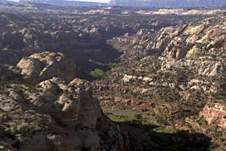
Then about 10 miles out of town I came upon an expanse of various rock
formations – some thing I was unprepared for.
The rock was various shades of white and red as far as the eye could
see. It was a stunning vista and the
road descended about 500’ quickly in a twisting, curling descent. Taking advantage of the bike, I stopped
numerous times to gaze at this wonderland.
 Continuing, I rode a few more miles
and then encountered the Boynton Lookout, an equally stunning view of a canyon
of red rock formations. The road
descended sharply into the canyon and suddenly I was riding within the cool,
red canyon walls. A short distance
later I turned off to Calf Creek Campground and got an immediate shock from a
sign – Campground Full. There was no
turning back to either Escalante or riding ahead to Boulder Town even if I
wanted to because there wasn’t enough daylight left. As I rode through the small campground of 13 sites the campground
hostess caught up with me and led me to an open site. I was relieved but she implied that they would have found a spot
for me if a site hadn’t been available.
Continuing, I rode a few more miles
and then encountered the Boynton Lookout, an equally stunning view of a canyon
of red rock formations. The road
descended sharply into the canyon and suddenly I was riding within the cool,
red canyon walls. A short distance
later I turned off to Calf Creek Campground and got an immediate shock from a
sign – Campground Full. There was no
turning back to either Escalante or riding ahead to Boulder Town even if I
wanted to because there wasn’t enough daylight left. As I rode through the small campground of 13 sites the campground
hostess caught up with me and led me to an open site. I was relieved but she implied that they would have found a spot
for me if a site hadn’t been available.
Obviously,
this was a popular site and it was easy to see why. It was a great setting, down within the dark red canyon walls,
quiet and serene. They also apparently
were having drinking water problems as they had a water tank trailer in the
campground for drinking water and the normal water faucets were locked.
I
quickly set up camp and cleaned up with a sponge bath next to the stream. The sun went down quickly, around 5:45, due
to the canyon walls although the temperature remained very pleasant for the
evening. However, the morning would
likely be cool, as it would take some time for the sun to climb above the east
canyon wall.
With
this peaceful setting, all I had to do was keep my mind off tomorrow’s 4,000’
climb that would start the day.
Day 20: 9/20/2001, Thursday
- Calf Creek CG, UT to Torrey, UT (pop 140) [51.4]
I was in
no hurry to get up since it was going to be a while before the sun would rise
above the canyon wall but I still got up around 7:30. By the time I ate breakfast and packed up, it was 9:00 and the
sunlight had worked its way down the west canyon wall and was creeping into the
campground.
 Today was going to be a tough day
with over 4,000’ of climbing and it started immediately as I left the
campground. I even had to climb to get
back to the road from the campground and then the road immediately climbed
steeply. I climbed 365’ in the first
mile but I was rewarded with great views looking down into the canyon where I
camped and beyond.
Today was going to be a tough day
with over 4,000’ of climbing and it started immediately as I left the
campground. I even had to climb to get
back to the road from the campground and then the road immediately climbed
steeply. I climbed 365’ in the first
mile but I was rewarded with great views looking down into the canyon where I
camped and beyond.
After
about 5 miles I reached the Hogback.
It’s claim to fame was a short section of road, maybe a third of a mile,
where the width of the road was the width of the hill with a sharp fall off on
both sides. I had heard about this from
multiple sources but it was not particularly dangerous, unless one had imbibed in
excess spirits.
After
surviving the Hogback, I climbed some more and then descended to Boulder Town
at about 11:00. Just outside Boulder
some horses ran across the road but I managed to avoid them. I stopped at a food mart for refreshments
and a burrito. I had thought Boulder
would be the halfway point of the climb but was dismayed to find it was only
about a third of the way and I still had 3,000’ to climb.
Taking
off at 11:30 I started a 78-mile constant climb at about 5 mph. The road never looked like it was much of a
climb but my legs told me differently.
In contrast to the earlier dramatic scenery, this part was more
conventional hills and fields with evergreens and aspen. Nevertheless it was nice scenery, especially
with the fall colors of the aspen.
Then the
road turned into a serious climb. For
the next 5 miles or so the climb was difficult, especially for a 2-mile stretch
where I was hard pressed to make 4 mph.
Then it eased occasionally which helped a lot. Early in this big climb there were some cows on the other side of
the road. As I passed them they looked
like they were baiting me but I stared them down so they wouldn’t make any
sudden moves across the road. Near the
top several lookout points gave dramatic wide panoramic views of the
breaks. It was a little hazy but you
could see for many miles.
Finally,
around 2:45 I reached the summit at 9,400’ after 4,425’ of climbing. It was a tough day and now all I wanted to
do was coast into Torrey but that would not be. It was 26 miles to Torrey, further than I thought. There were several campgrounds along the way
but I was short of food and needed to get to town.
It was a
big descent to Torrey, losing about 4,000’, but there were short stretches of
climbing. These were modest climbs but
not insignificant after climbing all day.
There were also some dramatic descent stretches where I exceeded 40+
mph. At one point I was on target to
break 50 mph until a curve in the road materialized and my hands squeezed the
brake levers without waiting for any conscious commands.
I
finally struggled to the intersection of 12 and 24 and I headed to the first
eating establishment I saw – a Subway.
I devoured a foot long sandwich and then an ice cream cookie sandwich. Fortified somewhat, I started thinking of
camping. There was an RV Park at the
intersection and conveniently located but it was just an open field. I considered it momentarily only because I
was so tired. However, next to the
Subway was an information center where I learned about two other possibilities,
1 and 2 miles further west. I decided
my legs could carry me at least another mile so I started riding. I rode through Torrey and found Sand Creek
Campground on the other side. It had
decent sites and was reasonably priced at $10.
It also had a hostel for the same price but I decided to stay with the
tent and privacy although I would have been the first one in the hostel for the
day.
After
setting up and cleaning up, I headed to the office for refreshments. There I met a motorcyclist from just over
the border in Canada. He had come down
through Idaho and Nevada to Las Vegas, through Mt. Zion and Bryce Canyon, and
was now on his way back home. He was
staying in the hostel so it turns out I wouldn’t have had the hostel to myself.
It was
an exhausting day but some fabulous scenery.
I just hoped that tomorrow’s ride through Capitol Reef National Park
would be more relaxing.
Day 21: 9/21/2001, Friday
- Torrey, UT to Hanksville, UT (pop 240) [54.9]
I got up
at 7:00. It was a bit chilly since the
sun didn’t come up until 7:20 and it was fairly windy. I packed up and rode the short distance to
Capitol Reef Café. It was fortunate
that the café was close by because the early morning sun was murder and I could
barely see even with sunglasses as I rode into the sun. I had buttermilk wheat pancakes and bacon
and the pancakes were the best of the trip so far although they could have been
larger. On my way out, I checked the
place’s book collection and picked up a book called Desert Time, A Journey
Through the American Southwest, by Diana Kappel-Smith.
I
started on my way and was helped with a good tailwind although I didn’t need it
because the route was almost all downhill.
I stopped at a mini-bike shop a few miles outside of town on 24 but they
didn’t have any chain cleaner. The guy,
after hearing my travel direction, advised I could get some in Durango.
Four
miles outside of Torrey I entered Capitol Reef National Park and the next 15
miles went through the park. There was
outstanding scenery through the park starting with dark red hills and gradually
changing to pale red and then white.
Initially, the huge hills were on the north side of the road but
eventually hills filled both sides of the road. On the west side of the park the hills were majestic with myriad
shapes such as chimneys and castles or whatever your mind could imagine. Towards the east end the shaped changed to
dome shaped limestone and petrified sandstone.
These domes were responsible for the Capitol in the park name.
At the
east end of the park I climbed a short 10% grade on a side road to supposedly
get a view of the waterpocket fold, a stretch of rock that extends over 90
miles south and catches pools of water when it rains. Somehow the expected view never materialized.
 Leaving the park I had 30 miles to
Hanksville, the destination for the day.
The ride through the park was outstanding not only for its scenery but
also its easy downhill grade. After
yesterday’s hard day, this day of active rest was just what I needed, probably
even better than total rest. The road
continued easy most of the rest of the way with only a few short climbs that
were miniscule in comparison to yesterday.
Leaving the park I had 30 miles to
Hanksville, the destination for the day.
The ride through the park was outstanding not only for its scenery but
also its easy downhill grade. After
yesterday’s hard day, this day of active rest was just what I needed, probably
even better than total rest. The road
continued easy most of the rest of the way with only a few short climbs that
were miniscule in comparison to yesterday.
The
scenery continued to be outstanding after the park although the landscape
opened up some and was not so in-your-face.
There was so much dramatic scenery that I continued to wear out my
camera.
About 8
miles outside the park I passed Sleepy Hollow Campground, appropriately named,
as there were no vehicle or signs of life.
A few miles later at Caineville a motel was similarly devoid of
life. However, a mile later I spotted
life at the Luna Mesa Café and stopped for a ham and cheese sandwich, the
special of the day. I was waited on by
a young girl who was followed around by a precocious 3-year-old sister. I didn’t really need to stop but I had
noticed the morning’s tailwind had changed to a modest headwind. So I thought it best to fuel up a bit in
case it developed into more than a cooling breeze.
After
Caineville, the scenery calmed down to where I could do some mindless easy
cycling the rest of the 18 miles to Hanksville. I arrived in town just after 3:00 but this was the stopping point
because the next services were 50 miles away at Lake Powell, tomorrow’s
destination. I stopped at a grocery
store as I came into town. Like every
place else the last couple of days, I was unable to find any good bread like
bagels that was useful travel food. I
did find some WD40 that I later used to clean my bike chain, preferring to try
it rather than waiting until Colorado.
In “downtown” I stopped at the Redrock Campground and secured a tent
site for $10 and cleaned up. I ate at a
nearby restaurant.
Back at
camp, I couldn’t write my notes outside due to the mosquitoes. The campground restaurant didn’t have a bar
area so I walked to another restaurant, slapping and murdering mosquitoes along
the way. When I entered the restaurant
I discovered it was non-alcoholic but they had a nice country band playing so I
made myself at home and wrote my notes while listening. Then after about four songs they quit at
7:30. I guess it was just time to call
it an evening.
Day 22: 9/22/2001,
Saturday - Hanksville, UT to Lake Powell, UT [53.2]
I got up
at my usual time and packed up. Then I
ate at the campground restaurant and had oatmeal and pancakes, a little on the
small side and just an OK breakfast.
Back at my campsite I met a guy from Ohio who had pulled into camp late
last night with his wife. They had
toured and backpacked through Colorado and were on their way to the Grand
Canyon. He was interested in my trip
and sounded like they would do some cycle touring some time in the future.
On the
way out I headed southeast on 95 to Hite Recreation Area at Lake Powell. The road started as a long gradual climb in
the 8-9 mph range. I was almost
relieved that the only significant scenery was the Henry Mountains ahead on my
right. I was able to focus on them and
not worry about what else I might be missing all around me. The other thing I was able to focus on was
the traffic, that is the boat traffic.
Almost every vehicle seemed to be towing a boat on a trailer on the way
to Lake Powell. Obviously people were
in a hurry to get to the lake as the boat traffic died down as the day wore on.
About
the first half of the route was a gradual uphill. When I reached the point where I would begin descending I met two
young women, Chris and Christie, from north of Seattle who were coming in the
other direction. We stopped and talked
about our trips. They had take the month
of September off and starting in Wisdom, Montana, had toured through
Yellowstone and down through Colorado.
They had taken a bus to Durango and were now doing my trip in reverse to
Bryce Canyon where a friend was meeting them and driving them back home.
Christie
had a Trek mountain bike and Chris had a Terry bike. They seemed to be having a great time on their first trip but I
felt a little sorry for them as they had some serious climbs on the way to
Bryce Canyon. We probably talked for close
to a half hour before parting ways.
They were planning an afternoon rest stop in Hanksville before
continuing to Cainesville.
 Continuing I started my descent to
Lake Powell. As I got closer I entered
a canyon with huge dark red walls. Just
a few miles from Hite I stopped at the Hite overlook that gave a great view of
Lake Powell from several hundred feet in elevation. Of course this was only part of Lake Powell. The Glen Canyon dam that creates the lake is
actually just over the border in Arizona and the lake extends 185 miles back
from the dam. Hite was 140 miles from
the dam.
Continuing I started my descent to
Lake Powell. As I got closer I entered
a canyon with huge dark red walls. Just
a few miles from Hite I stopped at the Hite overlook that gave a great view of
Lake Powell from several hundred feet in elevation. Of course this was only part of Lake Powell. The Glen Canyon dam that creates the lake is
actually just over the border in Arizona and the lake extends 185 miles back
from the dam. Hite was 140 miles from
the dam.
Although
I was only a couple of miles away as the crow flies, it was quite a bit longer
as the bicycle goes, having to edge around the lake to reach a couple of
bridges. Just across the main bridge I
turned right to reach the services area, just before 3:00. It had become quite hot and I quickly downed
a couple of cold refreshments.
Then I
was in a bit of a quandary. Tomorrow’s
logical destination was Blanding, 79 miles away but almost all uphill with
4,000’ of climbing. There was another
place 24 miles further up the road with some services. If I could make that today that would leave
a much more reasonable 55 miles to Blanding.
But it seemed to be getting hotter by the minute and the steepest part
of the climb to Blanding was the early miles.
So discretion finally got the best of me and I stopped for the day.
I found
a campsite away from the beach/landing area that was a zoo of vehicles. After setting up I walked to the beach and
went for a short swim in the comfortably warm lake to cool off and clean
up. Earlier when unpacking my bike I
discovered my right front rack’s vertical stabilizer bar had broken where it
connected to the bottom of the rack.
This explained the clicking noise I thought I had heard earlier on the
ride. I used some duct tape to
re-establish the connection, hoping that would serve at least as a temporary
fix.
Then I
walked the ¼ mile or so back to the grocery store only to discover it closed at
5:00 and it was now 6:00. Then I fed 4
quarters in one of the two vending machines outside only to find they were
completely sold out and I didn’t get my money back. So I resigned myself to drinking warm water the rest of the
evening.
Later I
took the time to cut my fingernails.
Since this was the first time on the trip, the clippings were
substantial. This apparently impressed
some ants around my tent. I saw several
of them congregate around one of the largest clippings. Then one asserted himself and started
dragging the clipping away, not an easy task as the clipping was much larger
than him. I hope the effort was worth
it.
Day 23: 9/23/2001, Sunday
- Lake Powell, UT to Natural Bridges Monument, UT [62.4]
I got up
at 7:00 but in no hurry because the grocery store didn’t open until 8:00. I stopped at the ranger station across from
the store and filled my water bottles.
Then I bought some milk so I could have real milk with my granola
instead of powdered milk. I picked up
some more food for the day including some pita bread, the first packable bread
I had found in some days.
I was
off by 8:45 climbing back to the main road and then a steep one-mile climb away
from the lake. Initially the views were
very scenic and then the road took to winding along the base of a mesa dotted
with junipers. The road climbed 3,000’
on a long gradual climb with an occasional dip in the road. As I was riding along side the road, I
caught a glimpse of something shiny. I
stopped and found a pair of sunglasses that I started wearing. My regular sunglasses were so dark that I
couldn’t use them with my camera. These
were lighter and provided a better view.
They were also apparently a woman’s model as they were oversized but
that didn’t bother me since I was more interested in function rather than
fashion.
After 24
miles I reached the Fry Canyon Lodge that I had considered trying for
yesterday. It took three hours so I
could have made it except for the possibly debilitating heat. However, the lodge had only a one-hour
window for serving breakfast and dinner.
Beyond that they had little so I settled for an ice cream and
refreshments and filling my water bottles.
 Continuing the road crept along the
base of the mesa and eventually reached the top of the cedar mesa. After 46 miles I reached the Natural Bridges
Monument turnoff and was faced with a decision. I could continue another 35 miles on to Blanding that included a
2,000’ descent and another 1,000’ climb or stay at Natural Bridges, which had a
campground and probably the only water until Blanding. Since it was only 3:00, I was pretty
confident I could make Blanding since I still had four hours of daylight and
two full water bottles. However, in the
end I decided to stop at Natural Bridges and see the sights.
Continuing the road crept along the
base of the mesa and eventually reached the top of the cedar mesa. After 46 miles I reached the Natural Bridges
Monument turnoff and was faced with a decision. I could continue another 35 miles on to Blanding that included a
2,000’ descent and another 1,000’ climb or stay at Natural Bridges, which had a
campground and probably the only water until Blanding. Since it was only 3:00, I was pretty
confident I could make Blanding since I still had four hours of daylight and
two full water bottles. However, in the
end I decided to stop at Natural Bridges and see the sights.
From the
turnoff it was 5 downhill miles to the visitor center where I got the lay of
the land and filled my water bottles since there was no water in the
campground. I paid a $3 entry fee, half
the vehicle charge, and $10 to camp.
The campground was almost deserted so I made sure I picked a site with
junipers for shade protection from the evening sun during this unseasonably
warm time.
At 6:00
I started the 9-mile loop tour of the natural bridges. This was the first time on the trip that I
rode without my panniers. While the
bridges were viewable from the parking areas, I imagine they would have been
more impressive viewed from their hiking trails. The second bridge was an example of sandstone that was worn
through by water hitting it from two directions. In effect, it never had a chance to be anything but a bridge. The last bridge came up just as the sun
disappeared. It was hard to see from
above since the rock background camouflaged the opening. I completed the loop and returned to camp
just as darkness set in.
Day 24: 9/24/2001, Monday
- Natural Bridges, UT to Blanding, UT (pop 3,118) [42.4]
The
morning was pleasantly cool as I got up, packed, ate breakfast, and left by
8:30. The climb from camp back to 95
was a modest 5-mile climb. On 95 it was
another modest 5-mile climb to reach the high point at 7,000’. Then it was a nice 10-mile descent with a
couple of 40+ mph sections.
The
descent bottomed out at Comb Ridge.
Comb Ridge was a long ridge perpendicular to my direction of
travel. However, there was a gap in the
ridge and a fairly steep climb transversely along the ridge led to the gap
followed by a U turn after the gap.
Some more modest climbing ensued and then there was a steep 1.3-mile
climb that was no fun. This was
followed by another short, steep climb.
On these climbs I oscillated between just under and just over 4
mph. I couldn’t help thinking these
climbs would have been real killers yesterday had I continued to Blanding. I’m sure I would have made it but it would
have been quite a grind at the end of a long day.
Finally
the climbing eased and farms and civilization appeared. I rolled into Blanding around 12:30 and
stopped for refreshments. Then I
stopped at the county library that doesn’t open until noon. I was able to check my email for the first
time in a week.
After
checking email I continued through town, scouting out prospects. I stopped for a well-deserved vanilla shake,
mailed a paperback novel home, located the Laundromat, and secured a motel for
$25.
After
settling in I did my laundry for the first time since my layover in Ely. Then I stopped at a Subway for dinner. I was lucky. There was no sign of life when I walked in. Then a helper appeared. Then it seemed like half the families (4) in
Blanding showed up with their kids. Had
I been 10 minutes later I would have gone some place else.
Blanding,
a town of 3,000, didn’t have a bike shop but I found a hardware store that had
Simple Green, a non-toxic biodegradable cleaner, that I have used before to
clean my bike chain. The WD40 I used
last week seemed to have made my chain dirtier and the chain looked much better
after I greened it.
Then I
retired to my motel for a relaxing evening.
It was another hot day although I missed much of the heat by arriving
before 1:00. The weather forecast
reported possible record temperatures for tomorrow and relief wasn’t in sight
for this unseasonable warmth.
I had
been planning a rest day once reaching Blanding. However, the next logical destination was Dolores, Colorado, 80
miles away including a 1,000’ climb to Monticello. So I was thinking of riding the 21 miles to Monticello tomorrow
morning and leaving a more reasonable 60 miles to Dolores the following day. This wouldn’t give me a complete day off but
I thought two shorter than normal days would equal a rest day.
![]()

![]()
Copyright
Denis Kertz, 2001. All rights reserved.