Fall 2013
Denis Kertz, ©2013
Day 6: Sat, Sep 07, 2013 - Hagelstein County Park ,
OR to Fort
Klamath , OR
It was a noisy night with US97 right next to the park along with a railroad but I slept okay anyway. I was on the road by 7:30. There was a lot less traffic on this Saturday morning compared to yesterday's Friday afternoon rush hour and there was a good shoulder. It was cool, in the mid-40s and the big hill on the east blocked the morning sun.
After 6 miles I
exited on to 
After 20 miles
So that made my
decision fairly easy. I could have just
shown up and hoped they would not turn away a cyclist but I wasn't given any
indication that that would be the case.
So I got a tent site at Jo's Motel for about $10 and then I called
After I set up
camp I read for a while and then decided to take a walk up the road. It was soon obvious there wasn't anything up
the road so I headed down the road. Then
I saw a sign for a Living Event History at the site of the
This turned out to be a reasonable way to spend a good part of my afternoon. In addition to the museum itself, now celebrating 150 years since the fort opened, there were exhibits of flint chipping, blacksmithing, and weaving. There was also a civil war exhibit. I learned about the rifles and pistols used in the Civil War as well as at this outpost. The guys who were dressed out in Union uniforms were obviously happy to share their knowledge about firearms during this period.
After about an hour and a half I walked back to Jo's Motel and had a hamburger and a beer. This place was an organic store and everything was organic including the beers. That along with the nearness to a national park meant nothing was cheap.
After eating I charged up my Kindle and my PC and settled in for the night.
Day 7: Sun, Sep 08, 2013 - Fort Klamath , OR to Crater
Lake , OR
My bike computer
said it was 36F when I got up but it didn't seem that cold. I was packed up and gone by 7:30 and with the
sun out it was fine for cycling. It wasn't
quite 7 miles to the very southern tip of 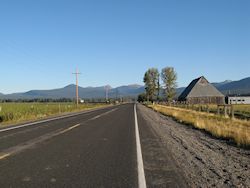
The climbing started as soon as I reached the park and it was a pretty constant climb. I rode between 3.5 and 5 mph but mostly 4-4.5 mph. There were a couple of turnouts that provided little breathers along the way through forests cut through by the road. At the last turnout, a picnic area, I applied some sun screen. Then when I pulled out onto the road I started going downhill. In a panic I looked around since I couldn't believe I had inadvertently turned south. Then I checked my elevation profile and saw there was a blip just a few miles from the campground that was my destination. In the end it was just a little over 1,600 feet of climbing over 11 miles where I thought it was about 2,000 feet.
I arrived before noon with the first order of business getting settled in the campground. As I figured I didn't need a reservation but it turned out to be useful. The lady who handled the check in wasn't able to print on her PC's printer but because she already had a printout of my reservation she was able to take care of me. She only had to update my rate from $21 per night to half that due to my senior pass.
There were A-G loops with the A loop just closing, a sign of the tailing off with the onset of fall. The G loop was designated for tenting only and I went there to pick my site. There were still folks packing up after 11am when they were supposed to be gone but there were plenty of sites to choose from. I chose G1 because it was close to the restroom and water and was off to the side to boot.
After settling in I walked back to the convenience store and had a sandwich and chips for lunch. I spent the rest off the afternoon reading and preparing my lightweight backpack for tomorrow's trip around the lake and hike to Mt Scott. Near 4 pm I walked back to the convenience store area where there was a restaurant and had an all you can eat soup and salad bar for $10. Then I settled in for the night and the big day tomorrow.
Day 8: Mon, Sep 09, 2013 - Crater
Lake , OR
My cyclocomputer said 35F in the morning and it felt about that. I ate and was on my way at 7:00, waiting for the sun to come out and warm things up. I had on tights, a short sleeve jersey, a long sleeve shirt, and a windbreaker and I was okay except my toes and fingers were chilled. I figure a little climbing would take care of that shortly and it did.
It was 6 miles,
mostly uphill to the beginning of the
My first stop was the Sun Notch Trail, a short trail that was smooth enough that I rode my bike since no one else was around and was comforted to learn that there was indeed a lake down there – a great view through a few trees of the lake and the Phantom Ship, actually a small island that looked somewhat like a ship. I didn't linger long because my goal was to get to the Mt Scott trailhead as early as possible to take advantage of the east morning sunlight.
Now I started
getting views outside the park whereas before I was riding through a
forest. I could see
There were
already 5-6 cars in the parking lot.
There wasn't a place to lock my bike in the parking lot so I stashed it
in the trees and set off. This trail
climbed to a lookout on the highest mountain in the
It was a hard hike. The trail went behind the mountain and then about 4-5 switchbacks until the final run to the lookout at 8,832 feet. As I neared the lookout 3 folks were leaving and another guy left not too much later. Three others joined me shortly after I arrived, 3 folks I had passed along the way.
Then disaster struck, or so I thought. My camera lens refused to open. I thought it must be stuck so I tried hitting the side of the camera with my hand to no avail. I switched batteries in case the batteries were too weak but that wasn't the problem. I was just about resigned to spending the rest of the day without a camera when I noticed the camera dial that selects the shooting mode was off the normal setting but that wasn't the problem. Finally I remembered that there was a switch to put the camera in view mode to check previously taken photos and found that it had been switched to view mode. Once I restored the switch to the normal photo mode the lens was fine again.
Relieved I took a
number of photos from a vantage point where you could see the entire lake. Unfortunately, I didn't feel I could linger
since I was only about a third of the way around the lake although I figured I
had covered the hardest part. It took me
about an hour to reach the lookout and by the time I spent some time fiddling
with my camera and admiring the view and walked back down I was right on the 2
hour time I expected. It was interesting
that there were a lot of hikers coming up the trail as I was descending,
another reason I wanted an early start.
I counted at least 16, 18 if you include the two toddlers piggy backing
on their parents, plus there were a couple in the parking lot looking ready to
head out.
Unfortunately, I didn't feel I could linger
since I was only about a third of the way around the lake although I figured I
had covered the hardest part. It took me
about an hour to reach the lookout and by the time I spent some time fiddling
with my camera and admiring the view and walked back down I was right on the 2
hour time I expected. It was interesting
that there were a lot of hikers coming up the trail as I was descending,
another reason I wanted an early start.
I counted at least 16, 18 if you include the two toddlers piggy backing
on their parents, plus there were a couple in the parking lot looking ready to
head out.
When I got back to my bike I was met with a surprise. When I went to unlock it from the tree it was leaning against I didn't find a lock. Turns out in my haste to get the hike underway I forgot to lock the bike and I carried the lock all the way up to the lookout and back for extra credit. Fortunately, the bike wasn't noticeable to someone unless they were looking for a bike to steal and knew one had to be around somewhere. So I dodged two bullets, my camera not working and my bike not locked.
Back on the road riding was a lot easier. I had a long downhill and somewhat less climbing than before. There were also a number of turnouts with views of the lake although the views weren't that great because the sun was overhead and it wasn't good lighting. I was also a little short of water. I had a regular and a large water bottle with me and I never ran out of water because I was rationing it. I'm sure I could have easily handled another large water bottle.
By the time I got
to the west side of the lake the sun had moved more to the west and the
lighting was much better as were the views.
I was on the side I passed by in 2009 when all I saw was a large ash
tray and now I got to see what 
There was a
little more climbing and then it was mostly downhill the rest of the way. I had seen a number of cyclists when I
started riding after my Mt Scott assault and continued to see more. When I reached the
Fortified by food
I descended further to the
It was a fast 7 mile return to the campground as it was all downhill. I stopped at the campground store for an ice cream that I felt I had earned and was reasonably priced. Then I continued to my campsite and unpacked and repacked my daypack into my panniers. After that I walked back to the store area where the showers were and spent $0.75 on a shower. I also grabbed a sandwich and fountain drink from the store and returned to feast at my campsite.
Later I met a guy
in my campground loop who had started doing the
All in all a good day of cycling and hiking. The weather was great if a little chilly at the start and the sky was clear all day. And it was nice to learn that there indeed was a lake down there and not somebody's idea of a hoax.
Day 9: Tue, Sep 10, 2013 - Crater Lake , OR to Collier
State Park , OR
I was in no hurry in the morning because I expected a relatively short day and I figured it would be better to wait for the sun before hightailing it downhill. I planned to stay in Chiloquin because the next stop along the way was 70 miles. I also decided to eat breakfast at the Annie Creek Restaurant which opened at 8:00. So it was easy to get packed up in the time limit and I was about 15 minutes early.
When I ordered my pancake/eggs/bacon breakfast I didn't expect too much so I was really surprised when I got two huge pancakes. This was more pancakes than most stacks of three. It wasn't cheap but at least there was quantity.
It was 9:00 by
the time I left and the first part of the day was to descend the 1,500 feet I
climbed to get to the park. After that
it was fairly flat until I reached the
When I reached
US97 I headed south to see how far a couple of possible accommodations
were. Within a mile I found Melita's
which had a motel, restaurant, and RV park with camping. With that located I rode into Chiloquin which
was a mile or so off of US97. There I
found a travel guide and I confirmed what I expected was ahead of me tomorrow –
nothing until
So I called Melita's and found they had WiFi not only in the motel rooms but in the restaurant so I went there and ate while connecting to the Internet. I also learned from my boss that the contract house that had been handling my part-time contracting had bowed out and we would have to find an alternate contract house. Normally this wouldn't have been that big a deal but trying to handle this at the last minute while on the road and not always in contact was not the best situation.
I debated staying
at the motel and having breakfast at the restaurant in the morning but in the
end I decided to put 5 more miles behind me by riding up US97 to
Then it was a short ride to the state park that turned out to be very busy. There were two loops and the outer part of the loop was for RVs and the inner part for tenters. They really packed in the RVs but it was a nice setting in a forest of pines that was thin enough to let in sunlight. And there were a lot of squirrels and chipmunks for entertainment. This was certainly a better camping setup than the RV park at Melita's.
So this was an easy day with almost no climbing but nothing could hide the fact that the next two days promised to be very challenging with near 100 mile days. I wasn't looking forward to that.
Day 10: Wed, Sep 11, 2013 - Collier State Park ,
OR to Christmas
Valley , OR
I wanted to get an early start because I had a long day ahead but I didn't get going until almost 7:30. For insurance I decided to carry extra water with one of my water bladders. I packed it on my rear rack and after I made a last stop at the restroom I noticed it was leaking. Fortunately, I had two water bladders and the second one didn't leak.
It was a half mile
back to the road and then a little over 15 miles until I picked up the
After 17 miles I
turned on to 
After the marsh
the road started some modest climbing with some ups and downs before descending
to
It became kind of
a slog the rest of the way on
I pushed on at 4
pm with 25 miles left to
Both routes
required getting over a ridge so there was some more climbing but nothing
really difficult. I rode north over the
ridge until I reached the
I reached
The bad news is that I couldn't connect to the WiFi in my motel with either Linux systems I have on my PC. This pushes me to ride on to Burns tomorrow since I know I can get WiFi some place there.
The big question was would I ride on to Burns tomorrow, just over a century, or take a rest day. I put off that decision until the morning.
Day 11: Thu, Sep 12, 2013 - Christmas
Valley , OR
I did not sleep well which was surprising given how hard yesterday was. Maybe this means I'm in better shape than I realize and didn't need all that sleep. When I got up at 6 my legs felt okay so I decided to push on to Burns and get this long stretch out of the way. Burns was about 10 miles longer than yesterday so carrying extra water was even more important. After thinking about it I found a better way to carry my extra water in the water bladder. Yesterday I layed the bladder on the rear rack and piled my tent and sleeping bag on top but that made me afraid to cinch everything down too tightly, leaving the tent and sleeping bag too loose for comfort. Today I tied the tent and sleeping bag down normally and put the bladder on top inside my duffel bag. This allowed me to tie down the duffel bag separately and it didn't need to be cinch down very tightly. This turned out to work very well.
After packing everything up I rode across the street to the Food Barn that opened for breakfast at 6:00. I had a good breakfast of 2 pancakes, eggs, and bacon. As usual in these small towns, there was a group of guys congregated over coffee and one guy was dominating the conversation.
I left just after
7 heading east on
The road was great with virtually no traffic. I felt like I had the road to myself. It was also dead straight for the first 19 miles. This along with 11 miles yesterday made this a 30 mile straight road, which was fairly impressive but not quite in league with the 90 mile straight road in the Australia Nullarbor.
After these 19
miles the road zig zagged a few times to work its way around the ridge
ahead. This was really nice riding and
nice scenery.
About 5 miles
from the end of this road at US395 I was approached by a motorcyclist. Turned out he was not sure where he was so I
showed him on a map. He was concerned
because he was low on gas and needed to find a service station. In the end he had to turn around and head
back to
When I headed
north on US395, the same US395 I rode from
Instead I stopped at Wagontire to find a place to sit out of the sun for my second breakfast at 12:30. After about a 25 minute break I pushed on with a long stretch of undulating road. There was a descent when US395 reached US20 and became US395/US20 heading east to Burns. Right at this intersection in a field on my left I saw some striped cattle and realized it was a herd of about 20 pronghorns. They eyed me warily as I took a photo and moved on.
I had a stroked of unexpected good luck at the intersection. This was Riley and I thought this was just a dot on the map but there was a post office and a food mart combined with an archery shop. I really didn't have time to stop as I had 27 miles left to Burns and would be pushing daylight but I couldn't afford to pass up a cold drink either.
After my drink I pushed on without knowing what to expect. When I made my elevation profile with RideWithGPS.com there was some data problem and this section to Burns just showed up as a flat line but I knew that couldn't be true. It wasn't and the road climbed some. Worse, this section of the road to Burns had rumble strips on the white line and just barely enough shoulder to the right to ride safely. In fact, later the shoulder deteriorated and I resorted to riding to the left of the rumble strips unless oncoming traffic forced me to the shoulder.
Then there was a big descent for a couple miles and then the rode flattened out to give me hope I could make town before night time. There was just a little more climbing for one hill but I think I had adrenaline pushing me on and I rode into town just as dusk was taking over. I turned my rear flasher on and would have used my headlight if I had had it mounted. As it was I could see well enough.
As I rode to the
center of town I saw a sign for the Sundowner Inn for $39 with WiFi, which
actually turned out to be in Hines, a sister city of
So it was a long,
hard day but I was glad I had pushed on and now had what would likely be the
two hardest days of this tour behind me.
In any event, I was now well situated to make
Day 12: Fri, Sep 13, 2013 - Burns, OR to Burns, OR [10.0, 1:04:29, 9.3 mph, 182']
It was nice to
have a rest day and not have to get going quickly as I had the last two days to
take advantage of the available daylight.
I was able to get caught up on my email, wash some clothes, and
lubricate my bicycle chain. I also rode
through the downtown area of this Burns-Hines metro area of 4,300. 60% of this
Day 13: Sat, Sep 14, 2013 - Burns, OR to Juntura , OR
I packed up and ate at the restaurant just down the road with a ham omelette and pancakes. Good breakfast but pretty expensive. I left town just before 8 on what I expected to be a fairly easy day, especially compared to the two previous days.
Just as I left town I saw a portable electric street sign warning drivers to watch for cyclists for the next 35 miles. I wondered what made the next 35 miles dangerous. Then I remembered that the Oregon Bicycle Ride had gone through Burns and I wondered if this was for that.
It was a 25 flat miles through more hay country and irrigated fields. It was obvious at some point I would have to climb because there were only hills ahead in the distance. After a while I looked for some place to pull over for a second breakfast but there wasn't any place to sit or get out of the sun. Then I saw a semi parked along the road and thought that would be the best I could do. I leaned my bike against the truck and sat against the rear out of the sun for my breakfast.
Then I couple miles down the road I stopped at Buchanan. I thought this was just a dot on the map but it had a service station with a few supplies. This would have been better for breakfast since I could have gotten real milk rather than powdered milk. Instead I got a cold drink since this would be the last chance until the end of the day. I also filled my large water bottle so I had plenty of water for the day. Then the proprietor told me that 2,000 cyclists had passed through yesterday morning and that confirmed my theory about the bicyclists warning sign. The proprietor said it was the most people that had ever been in Buchanan in a day.
Then began the
first major climb to
The scenery
continued great for 8 miles or so until the climb to 
Juntura was just a small place with a combined motel/cafe/RV park. I had called ahead yesterday for a motel reservation to be sure this place was still open and that I could get a spot. The last thing I wanted was to have to ride 120 miles to Vale today.
The room cost $51 and was fine. I ate at the restaurant and that was okay. Apparently the big name for this place was the milk shakes. When I got to this place I had to wait for the waitress while she was making 4 milk shakes and she was making milk shakes again later when I ate.
The motel room was nice but it didn't have WiFi and didn't have any TV channels. It did have a DVD player connected to the TV but that was of no interest to me.
During the day I passed into the Mountain time zone and I had to shift my watch up by an hour. Changing time zones is always a bit of a pain because when touring you really care about daylight and you have daylight dialed into the current time. The time zone puts that association out of whack but you have to make the change because local establishments run on that time and you need to know it for things like opening and closing of restaurant service. So it will take a day or two to get recalibrated to the new time zone.
Day 14: Sun, Sep 15, 2013 - Juntura ,
OR
The cafe didn't open until 8:00 on Sundays so I had to wait a bit for breakfast. I felt a little guilty being the only one waiting for the cafe to open but a couple of other folks showed up shortly after. I had pancakes and they were fine.
I left about 8:30
which was 7:30 on my old pacific time.
The route descended about 700 feet over 55 miles so it was a very
gradual descent. I didn't expect great
scenery but I was in for a big surprise.
The road followed the  After about 5 miles the passage widened a
bit. This was all very scenic with a
winding road and river and there was a good shoulder. There was a fair headwind that was probably
amplified by the canyon-like creation by the steep hills.
After about 5 miles the passage widened a
bit. This was all very scenic with a
winding road and river and there was a good shoulder. There was a fair headwind that was probably
amplified by the canyon-like creation by the steep hills.
It was a very enjoyable 25 miles before the hills receded somewhat and the scenery became more open. After 33 miles I stopped at a service station in Harper expecting to be able to get cold milk for my second breakfast around noon but was disappointed. The place only had regular soda and such drinks. So I used powdered milk again and then had a cold soda afterwards.
I spent some time
fiddling around with my GPS to find out what kind of accommodations might be
available beyond Vale. Vale was only
about a 60 mile ride and I was hoping to find something around Nyssa that would
add 20 miles to shorten tomorrow’s ride into
When I left around 1:00 it was suddenly rather warm. Fifteen miles from Vale there was a 300 mile hard climb, the only significant climb of the day. I was also fortunate that a big cloud hid the sun and the temperature was quite comfortable. After the climb it was a fast descent and then 10 miles to Vale. These last miles were through large farm fields of corn, cabbage, and onions.
There was a motel just as I entered town. I rode a little further to a food mart for a large cold drink. I wrestled again with whether there was a reasonable continuation route for the day but nothing was obvious. Then to make matters worse the sun was back out in full force and it was very warm. Later I saw a temperature sign that said 90F.
I got a room at the motel for $46 but was disappointed it had no WiFi. I walked a couple blocks to a cafe and dragged my PC along just on the off chance it might have WiFi. I was in luck that it had WiFi but was unable to connect. There was a password and there was some question whether I had the right password. Just as I was about to try something else my PC's list of hot spots showed the signal strength for the cafe WiFi had mysteriously almost disappeared but another WiFi signal without a password appeared. I tried it and successfully connected. I had a humongous hamburger and took care of email and a few other things while I was at the cafe for a couple of hours.
I checked the weather forecast for the next couple of days and the forecast was for rain tonight. Looking outside I could see the clouds looking ominous so I packed up and left to make sure I could get back to my motel room without getting wet.
![]()

![]()
Copyright
Denis Kertz, 2013. All rights reserved.