Fall 2013
Denis Kertz, ©2013
Day 27: Sat, Sep 28, 2013 - Garden City, UT to Evanston , WY
I didn't sleep
that great and part of the reason was my bed had an awful mattress. It felt like a big sponge. It's been a long time since I had a mattress
like this one. Maybe because I felt uncomfortable
I also got uncomfortable about
When I got up at 6 I decided I needed to research this a little more. I couldn't find anything really definitive but the primary Mirror Lake Campground has a reservation system and the web page said it closed around Labor Day. It wasn't clear whether this meant the campground closed then or that reservations could no longer be made. Unfortunately, I really should have done this checking yesterday when I could have called a forest service office and inquired directly but it was Saturday now and that wasn't possible.
Aside from the
campground status the weather prediction for the next two days was for very
windy, out of the south/southwest, which meant a strong headwind for me. In the end I decided I needed to research an
alternate route. I was able to come up
with a route that had me heading east from
Doing all this research didn't hurt my schedule because the restaurant next door didn't open until 8 am. I had a good breakfast of 2 pancakes, bacon, and eggs. With breakfast out of the way I left town just after 9. There was a paved bike path for about 3 miles before I had to get on the road with no shoulder. It was in the mid-30s but it didn't take long for the temperature to reach the 40s. In less than an hour I was down to just my short sleeve jersey and long sleeve shirt.
It was 10 miles
to Laketown at the south end of 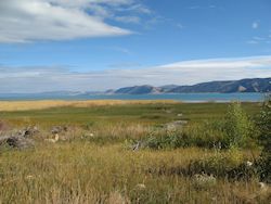 The two sides of the valley converged at the
south end of the lake and I understood why I had a 1,000 foot climb after
Laketown – I needed to climb to get out of the valley.
The two sides of the valley converged at the
south end of the lake and I understood why I had a 1,000 foot climb after
Laketown – I needed to climb to get out of the valley.
I stopped at a food mart in Laketown and bought some milk for a later breakfast. While I was there 2 cyclists rode by and turned to go up the east coast of the lake. It was probably 45-50 miles to ride around the lake and I guessed that was what they were doing. I would imagine riding around the lake was a popular bike route.
Leaving Laketown, I started the 3-mile, 1,1000 foot climb through a slot canyon. The first half of this climb was steep and I moved at a 3.5 mph rate. The latter part of the climb was not quite as steep. When I got to the top it was a nice 20 mph descent, giving up most of the altitude gained on the climb. I stopped along the way for my second breakfast.
When I left I had
covered 20 miles and it was already a little past noon and I had a little more
than 40 miles still to go to
The ride south
along UT16 was through the
There were a couple of small towns along the way. The first was Randolph, a town of 464 with the dubious distinction of the highest voting percentage – 95.6% - of any city in the country for George Bush in the 2004 election. I stopped there for a chocolate milk and a pastry. Another 10 miles later was Woodruff, even smaller at 180, where I stopped for another drink and snack.
The route had
been essentially flat other than for the big climb out of the
I had my eye on an Econolodge as my best motel bet based on Google maps and thought I would see it riding in on WY89 but I missed it. So I pulled out my GPS to let it guide me there. When I got there I learned that their WiFi was out so I had to find another motel. I looked at the list my GPS gave me and picked an unknown brand. As I followed my GPS I spotted another motel, the Vagabond, and inquired. It turned out to be a good deal at $43, at least $10 better than I thought I could do.
After cleaning up I walked to a buffet that I spotted while looking for the motel. It was a Chinese buffet that was okay. Then I retired to my room to do some more research on my alternate routing for tomorrow.
Day 28: Sun, Sep 29, 2013 - Evanston , WY to Fort
Bridger , WY
It was nice to get a good night's sleep in a real bed after the experience with the sponge bed the night before. There was a diner just down the road from the motel where I had a good pancake breakfast with ham and eggs although the pancakes were a little small.
I was at the east
edge of town so it was a simple matter to get on the Interstate. My goal was to make Vernal, UT, in 3
days. Given the availability of towns
and services I expected this to be a short day.
The main question was whether I would have to ride the Interstate all
the way to
I rode the Interstate a few miles to the next exit and then found a paved frontage road but I wondered if the pavement would last and the answer was no. After a couple of miles the pavement ended and I had to get back on the Interstate. Rather than ride back to the exit I unloaded my bicycle and carried my panniers to a fence and dropped them over the fence and did the same with my bicycle. Then I carried everything up to a guardrail and reloaded my bicycle. This took about 20 minutes.
Like most Interstates I-80 had a wide shoulder but unlike any other Interstates I have ridden this one had rumble strips. Fortunately, these rumble strips had narrow, shallow grooves that weren't a problem to ride across on a bicycle and they occurred repetitively, about every 30 yards. One type was hardly noticeable to ride over but another type had a little deeper V-shaped grooves that were a little more intrusive but still not a problem.
There were 3 long
hills and corresponding descents in the 30 miles to the  Of course it was noisy and there were a lot
of big trucks. On every hill the road
expanded to 3 lanes with trucks/busses restricted to the 2 rightmost lanes to
allow faster cars to pass in the outer lane.
The only problem with this was on the second hill this cut into the
available real estate for the shoulder and the shoulder was only about 5 feet
wide, a little too narrow for comfortable riding at 4 mph amongst high speed
traffic.
Of course it was noisy and there were a lot
of big trucks. On every hill the road
expanded to 3 lanes with trucks/busses restricted to the 2 rightmost lanes to
allow faster cars to pass in the outer lane.
The only problem with this was on the second hill this cut into the
available real estate for the shoulder and the shoulder was only about 5 feet
wide, a little too narrow for comfortable riding at 4 mph amongst high speed
traffic.
It was good that
I changed my route to head east rather than south via the
After leaving the
Interstate I rode a couple of miles to
There was a small restaurant across from the museum where I decided to eat. I perked up at the sign of buffalo burgers but lost my enthusiasm quickly when I learned one would cost $14.29, twice the cost of a regular burger. There was a motel and an RV camp in town. The motel wanted $52 for a room so I figured I could do better camping until I learned the RV camp wanted $33 for a tent site which was a joke. In the end it probably was good that I didn't camp because it was very windy and gusts up to 40 mph or so were expected.
It would have
been nice to ride a little further but the next town,
Day 29: Mon, Sep 30, 2013 - Fort Bridger , WY to Manila ,
UT
I ate breakfast at the cafe right at the motel. It was an okay pancake/eggs/bacon but expensive. I wanted to get an earlier start than the past few days to minimize the effect of the wind which would pick up through the day. Hopefully I would get the southern route part out of the way before the wind, expected to be out of the southwest, would be too strong.
I left a little
after 8 and rode a few miles east and then took WY414 south. It was immediately clear why the next town
was called
When I left town
the road curved to the east for a few miles.
That gave me a tailwind and riding was easy with good views of the
Unintas to the south. Then the road
turned south and the wind became mostly a cross wind but some head wind
also. It was slow going with the wind
and more climbing than I anticipated but the views were very nice. Much of the area was sandstone hills that
were carved every which way with different layers of sediment.
With the force of
the wind it was a challenge to pick a place for a second breakfast. I finally stopped at 10:30 by a bit of a hill
next to the road where I could sit and most of the wind was blocked. When I resumed riding I kept waiting for
every turn in the road to finally turn east so I would have a tail wind. At noon I finally the
It was obvious that the road had to head east for a while because the Uintas were due south and the road needed to head east to get to a point where a path could be found through the eastern edge of the Uintas. Once I started riding east the land opened up into a big valley and you could see for many miles to the east.
The road started
winding some with undulations before it started a fast descent to
After setting up my tent and hoping the wind wouldn't blow it away, I started to walk the short distance to town for food but the KOA proprietress was driving to town anyway so I got a lift. I had a good Mexican dinner and then I did a little grocery shopping at the store across the road that had everything – groceries, liquor, hardware, etc.
I walked back to the KOA, showered, and then retired to the laundry room to do a load of laundry and use the WiFi.
Day 30: Tue, Oct 01, 2013 - Manila ,
UT
I packed up by 7:30 and rode down the hill into town for breakfast – 3 pancakes that were okay. When I left I rode up to a food mart and got some milk and a breakfast sandwich to augment my pancakes. Then I headed south on UT44.
I had a couple of
climbs leaving town and then a big descent into
Then just ahead I
started getting good views of  There were also great views of the valley
looking back the way I came. This climb
would have been very hard but was made easier because I kept stopping to take
in the views and take photos. I stopped
one last time at the Sheep Creek Overlook and had my second breakfast there.
There were also great views of the valley
looking back the way I came. This climb
would have been very hard but was made easier because I kept stopping to take
in the views and take photos. I stopped
one last time at the Sheep Creek Overlook and had my second breakfast there.
Then the road kept climbing but left the Flaming Gorge view behind. I started getting worried because I hadn't covered much ground and I had a long ways to go to make Vernal. Yet the road kept climbing with only a few modest descents.
The KOA lady had
suggested I take in the
So I had to settle for the view, which as the name suggests, was the water passing through a very deep, maybe a thousand feet, red canyon. I also had a bonus sighting of a bighorn mother with her kid by the visitor center. Then I had to retreat back to the road after about an hour detour with about 200 bonus feet of climbing.
When I got back on the road it was 3 miles to where UT44 ended and I picked up US191 to Vernal. The KOA lady told me once I picked up US191 it was all downhill to Vernal. I know enough to not trust non-cyclists who don't appreciate the difference between driving and riding. So I had checked my elevation profile and could see there was still climbing once I reached US191 but even I didn't appreciate how much climbing was still left. When I checked my elevation profile later I saw the problem was that the upcoming 9-mile downhill dominated the profile and hid the other climbing parts that were small scale by comparison.
When I started on US191 the climb initially headed east and then turned south. Once I was heading south I got hit by a fairly strong headwind. I wasn't expecting that and the first 9 miles on US191 were very slow. I hoped the headwind was because of the high elevation and would dissipate as I descended.
After the slow 9 miles and climbing 900 feet I reached the summit at 8428 and then started some descending but I wasn't finished climbing. There were still 3 other climbs including one long one. Then magic appeared in the form of a sign that warned of 9 miles of 5 to 8 % descending down 10 switchbacks. The KOA lady had mentioned the switchbacks so she was right about that but way off otherwise.
The switchback descending was great fun, weaving downhill around 30 mph with a descent of 2500 feet. After the first switchback another sign announced 9 more switchbacks to come. Then after 3 or 4 switchbacks the view opened up to a wide panoramic view of a mountain below. This was totally unexpected and just a fabulous view.
When the switchbacks and the fun ended there was another substantial climb with about 10 miles to go. I really needed more descending to get to town before dark. Fortunately, there was only a single very modest climb after this one so I was able to ride the remaining miles to town at about a 15 mph pace.
I had planned to
stay in another KOA for the night but I didn't make it to town until 6:30. The lateness of the hour and the fact the KOA
was on the outskirts of town and not near any services caused me to forego the
camping. Instead I got a room at an
Unfortunately, the motel wasn’t very well located with respect to food. I had to walk several blocks to find a couple of eating places. I chose an Asian restaurant which was fine except the service was really slow. I started to have a fit when I couldn't even get a drink which I was much in need of. But the drink finally arrived and the food later.
Then I retired back to my motel to plan tomorrow's adventure.
This was a very
hard day and when I checked I found I had climbed a mile. The views at
Day 31: Wed, Oct 02, 2013 - Vernal, UT to Rangely, CO [56.2, 5:59:54, 9.4 mph, 1,868']
The continental
breakfast had a waffle maker so I had 2 waffles and 2 (small) bowls of
cereal. I left shortly after 8 and
stopped at a Maverik on the way for my milk.
It took about 5 miles to get through the metro area of Vernal and
After crossing
the  US40 didn't have a very good shoulder because
it had rumble strips. So mostly I rode
to the left of the white line and ducked into the narrow shoulder right of the
rumble strips when traffic approached.
There was a fair amount of large truck traffic but they invariably eased
over into the next lane when they could when they passed.
US40 didn't have a very good shoulder because
it had rumble strips. So mostly I rode
to the left of the white line and ducked into the narrow shoulder right of the
rumble strips when traffic approached.
There was a fair amount of large truck traffic but they invariably eased
over into the next lane when they could when they passed.
In late morning I
started looking for a place where I could have my second breakfast. It didn't look promising that I would find a
good spot along the road but then a scenic overlook appeared and it was
perfect. It had a john, a picnic table
under an overhang to block the sun, and a view of the
After breakfast
the road passed through about a 10 mile long basin. After the basin crossing I entered
It was 18 more miles to Rangely almost all a gradual downhill except for one fairly hard 2.5 mile climb. I made it to Rangely just after 3:30 and rode through town checking it out. I stopped at the Chamber of Commerce that I remembered being next to the library from my visit in 2006. A lady told me there was a town park at the east end of town, which I don’t think was there on my previous visit, so I headed there and got a camp site for $15 that included showers.
After setting up I walked back to a bar in town for a sandwich and a beer and used the WiFi to check email and write my notes for the day. The big question is the weather that is questionable for the next 2 days. I had thought it would be best to sit out tomorrow because of projected rain but now the rain seemed to be predicted for late afternoon and then some rain/snow showers Friday morning and colder. I would have to check the weather again in the morning and make a decision.
Day 32: Thu, Oct 03, 2013 - Rangely, CO [layover]
Today was a
mess. The weather was looking okay when
I got up but it was projected to rain in the late afternoon. On top of that the wind was out of the
south/southwest. My planned route had to
climb
I ate breakfast at a coffee house and had great pancakes, probably the best of the trip. I was still considering riding on but then clouds started moving in and looking threatening. I finally decided I just wasn't up to fighting a headwind for what would be a long day plus the risk of rain on top of it. I took advantage of the time to mail a bunch of stuff home that I had collected on the trip like maps and brochures rather than continue to carry that deadweight. Then I stopped at the library only to discover they didn't have WiFi, which the assistant librarian didn't know. She also didn't know they had maps but I found them and let her know where they were.
The library did
have a number of Internet PCs and I was able to use one. That's when I finally looked at an
alternative route by riding east to Meeker and then south. This bypassed
Excited about riding to Meeker, I grabbed something to eat and headed out. But I didn't get very far as I did some mental calculations. It was almost noon and it was 53 miles to Meeker on a gradual uphill. I figured even if I could average 9 mph it would be about 6pm before I could make Meeker. That seemed rather risky, kind of a best case scenario. This didn't seem like a good bet on a weather risky day. So I turned around and resigned myself to spending the day in Rangely.
The worst part about staying in Rangely was that the cheapest motel was $89. There was a lot of oil work going on and the motels were almost full. No doubt the motel price reflected this seller market.
After I settled in my motel I read a little and then took a nap. When I woke a little before 4 it was raining. Then about an hour later it was snowing. It was wet snow that wasn't sticking but it was still snow and it was going to get colder. I realized that I would have had a pretty miserable afternoon riding to Meeker. On the other hand, if I had thought about riding to Meeker early, I could have made it and missed most or all of the wet weather and I would have had a much better motel situation.
Later I put on my rain gear and walked to a Subway. Two other guys got there just ahead of me. The first guy said he was going to pay for his partner but the staff put my sandwich on his bill as well. For some reason the staff didn't know how to fix a credit card payment so I reimbursed the guy $6.75 for my sandwich. Then I told the staff I wanted to make a meal out of my sandwich and she wanted to charge me separately for a drink and chips, close to twice the cost of including it in a meal deal. When I objected she ended up just giving me the drink and chips and I didn't argue. So I ended up with a pretty good deal - $6.75 for a foot long meal.
Due to the government shutdown, I discovered I couldn't get the NOAA weather website. Then I found I couldn't get accutweather.com or weather.com so I guessed they must rely on the NOAA data. Finally I found the wunderground.com site so I could keep tabs on the weather. Tomorrow didn't look good and it looked like I would probably be spending another expensive motel day in Rangely.
Day 33: Fri, Oct 04, 2013 - Rangely, CO [layover]
It was an
interesting night. The snow yesterday
was very wet and it created havoc with the trees by breaking limbs. As a result Rangely lost power several times
through the night and again a couple of times today although the power outages
today were relatively short. There
wasn't much question about riding today.
It would have been possible if it was a desperate situation but I wasn't
desperate. I had a leisurely breakfast,
a good omelet, at the coffee house which was very crowded. It was a good thing I wasn't in any hurry.
As a result Rangely lost power several times
through the night and again a couple of times today although the power outages
today were relatively short. There
wasn't much question about riding today.
It would have been possible if it was a desperate situation but I wasn't
desperate. I had a leisurely breakfast,
a good omelet, at the coffee house which was very crowded. It was a good thing I wasn't in any hurry.
After breakfast I walked across the street and signed up for another expensive day at the motel. I kept kicking myself for not realizing sooner that I could route to Glenwood Springs via Meeker yesterday. If I had I would have been in Meeker last night where there are a bunch of motels and it would certainly have been less expensive.
I spent part of the day reading. On this trip for the first time I brought a Kindle PaperWhite along rather than paperbacks. This has worked very well since multiple books can be loaded on the Kindle without additional weight. On top of that I can check out Kindle books from my library remotely and they automatically expire so there's no issue of having to physically return a book or forget to return one. This Kindle works well also in a tent because it has its own backlighting and can be read in the dark. And there's no need to hold a book open and turn pages. I can simply prop the Kindle up against something and tap the screen when I need to turn a page.
Today, I completed my third Kindle book. The first two were basically generic mystery fiction but the one I completed today was Cheryl Strayed's “Wild (From Lost to Found on the Pacific Crest Trail)”. The first two books I had preloaded on my Kindle prior to my trip but this Wild book I checked out of the library while on tour.
The other
activity that kept my attention was finalizing the end of my trip. My reason for ending the trip at Glenwood
Springs is because it has an Amtrak station with baggage service so I can get
my bicycle home. It is trivial to pack
up a bike in an Amtrak box – just remove the pedals and turn the handlebars sideways,
which is much easier than disassembling a bicycle to pack in a bicycle box that
can be taken on a plane. However, my
planning also involves visiting my nephew Nick and his family near
Unfortunately,
another wrinkle is that the
Another wrinkle in all of this planning, as if there weren't enough, is that I would like to meet Kelly, another touring cyclist who helped me plan part of my trip. She was the one who clued me in that Glenwood Springs had baggage service or I might not have figured that out. As it happens, Kelly lives in Rifle so it would be nice to at least have a quick visit if nothing else.
Day 34: Sat, Oct 05, 2013 - Rangely, CO to Meeker, CO [61.1, 6:39:51, 9.2 mph, 2,647']
There was no hurry to get up in the morning because I probably didn't want to leave before 9am to give the day a chance to warm up a bit. Then right at 7 we lost power again. I hoped this wouldn't last long so I could get breakfast before I left town. I walked the couple blocks to the coffee house and was gratified to see the Open sign lit up. I figured they hadn't lost power in this part of town but the waitress told me that it had just turned on. I had their pancake breakfast again which wasn't quite as good as the first time because the pancakes weren't quite as big. I was surprised to see hardly anyone in the cafe but then realized it was Saturday and a lot of the oil workers probably had the weekend off.
It felt like it was about freezing when I left at 9. I had my cold weather gear on and I was very comfortable. The route to Meeker was a 60 mile gradual uphill gaining 1,000 feet of altitude with one significant climb. I had ridden this route in 2006 and enjoyed it but I rode it in reverse so I'm sure that added to the enjoyment. Nevertheless, it was a nice, scenic day despite being uphill.
Five miles outside of town there was a dam that created the Kenney reservoir that I remembered from the last time. The hills were still dusted with snow. The road rarely had a shoulder but there was very little traffic and that could have been partially due to the weekend. So it was a pleasant ride through a scenic area.
Around noon I realized I was going to have a problem finding a good place to stop for my second breakfast because of the lingering snow. When I reached the top of the one significant climb, I stopped because there was a bit of (dry) shoulder I could sit on that was safe from traffic.
After descending
from this climb I crossed over the White River and rode through the 
I rode into Meeker just after 4 and rode through town checking out the motels and restaurants. At the other end of town the Rustic Lodge advertised rooms for $45, half the price of what I paid in Rangely. I didn't figure I could beat this but called a couple other motels that looked like they might be reasonable and they were $20 more.
When I stopped in the Rustic Lodge office I met up with a charming grandmother who was trying to hold the fort while here daughter was out dog walking. She didn't quite know what to do but it was fun watching her trying to decide what she should do. She eventually drove off to retrieve her daughter.
I had to wait for
a room to be made up so I rode back down the street and stopped at an Italian
restaurant where I had a large
When I got back to the motel I called my nephew to set up arrangements for him to pick me up tomorrow when I get to Rifle.
Day 35: Sun, Oct 06, 2013 - Meeker, CO to Aspen , CO
Meeker is a town of 2,475. It was founded in 1843 when the Army abandoned an outpost and sold its barracks and buildings to homesteaders. This led to the start of the Meeker Hotel & Cafe. Yesterday when I ate at the Italian restaurant I asked for a recommendation for breakfast and was told the Meeker Cafe was the only option. In a brochure handout I got from the Chamber of Commerce building I learned that the Cafe was open on Sundays 8 am but I called to confirm that just to be sure and learned that it actually opened at 7 am. Since I wanted to get an early start I showed up at the Cafe at 7:15 and had a good breakfast of ham, eggs, and pancakes.
When I left shortly after 8 it was still chilly and probably about 30F but I was dressed for the cold just like yesterday and was comfortable. I backtracked 3 miles to the junction of 64 and 13 where there was a food mart and I got my milk for my second breakfast. Then I headed south on 13.
Rifle was 37
miles away. Initially the road climbed
1300 feet over 12 miles then it flattened out with some undulations before
descending 2000 feet over 15 miles to Rifle. The initial climbing was modestly steep that
I climbed at 5-7 mph with a good shoulder.
Yesterday I was surprised that I didn't have to discard any layers of
clothing for the entire day which meant the temperature didn't rise that much
throughout the day and this was undoubtedly affected by the 1,000 feet altitude
gain. Today I had to remove my
windbreaker about halfway up the climb.
The initial climbing was modestly steep that
I climbed at 5-7 mph with a good shoulder.
Yesterday I was surprised that I didn't have to discard any layers of
clothing for the entire day which meant the temperature didn't rise that much
throughout the day and this was undoubtedly affected by the 1,000 feet altitude
gain. Today I had to remove my
windbreaker about halfway up the climb.
Today I started looking for a place for a second breakfast around 11. Shortly after I completed the 12 mile climbing stretch I stopped at what was labeled a rest stop. I was expecting a typical rest stop but it was just a men & women’s outhouse and 2 picnic tables. Fortunately, I didn't need the outhouses which had no toilet paper but I did use the picnic tables. The good thing about the picnic tables were they were made out of a smooth marble like structure so they weren't wet like wood would have been.
Once I completed the basic climb the good shoulder went away and there was at most a foot of shoulder and less in many places. Since this was a Sunday there was relatively little truck traffic so the lack of shoulder wasn't a big concern.
When I started the 15 mile descent to Rifle I was expecting a wild descent based on my elevation profile but it was a fairly modest descent. Still it was a descent and not a lot of pedaling was required to keep the descent in the 16-20 mph range.
I rode into Rifle just before 2pm with plans to meet with a fellow touring cyclist, Kelly, who I had never met in person but knew from an Internet bicycle touring group. I followed Kelly's directions into town and then called her. Kelly lived only a couple of blocks away so we met up quickly and then Kelly treated me to lunch at a nearby restaurant. Of course we spent a lot of time talking about bicycle touring since we both have had a lot of experience.
Eventually, my
nephew Nick, his wife Sabrina, and their two children, Johnny (8) and Genevieve
(almost 6) showed up as Kelly and I wound up our visit. Nick put my bicycle on the rear carrier he
had on their van and we headed off to their home near
Day 36: Mon, Oct 07, 2013 - Aspen ,
CO
Sabrina got the
day off to a great start by making waffles for breakfast. The kids had to go to school and Nick had to
work but Monday was an off day for Sabrina.
After a 10 am commitment Sabrina took me out on the town. First, she drove me by the property that Nick
manages for a wealthy owner. Then we
went into
Back home we met the kids at the bus returning from school. Nick didn't return from work until around 6:30 and then Sabrina had a meeting commitment so Nick cooked up antelope burgers from one of his hunting escapades. Then we watched a tense Cardinals-Pirates 2-1 baseball playoff game that evened the series.
Day 37: Tue, Oct 08, 2013 - Aspen ,
CO
I had a 12:45 pm Amtrak ticket at Glenwood Springs so I needed to leave early to be sure I could cover the 35 miles in time. So I ate a quick breakfast, finishing off the last of my cereal. I had my bicycle all packed and only had to put on my cold weather riding clothes for the near freezing temperatures. I said my good-byes to Nick, Sabrina, Johnny, and Genevieve as they were working on their breakfast.
The ride to
Glenwood Springs was relatively easy. It
was 35 miles of gradual downhill losing 1500 feet of altitude on the Rio Grande
Trail, a paved bicycle trail, a rails to trails conversion of an old railroad
to gain access to Aspen’s silver deposits in the late 1800s, that went the
entire way from Aspen to Glenwood Springs.
It didn't get much easier than this but pedaling was still required on
the gradual downhill. The temperature warmed up enough that by the
time I reached Glenwood Springs I had to remove my windbreaker and heavy
gloves. I overshot my turn onto
The temperature warmed up enough that by the
time I reached Glenwood Springs I had to remove my windbreaker and heavy
gloves. I overshot my turn onto
I reached the station just after 10. I was worried no one would be there but the attendant said he was glad I was early so we could take care of my bike and packing. I got the regular Amtrak bike box, removed my pedals, and turned my handlebars and rolled my bike into the bike box. That was the easy part. The harder part was re-packing my panniers to get everything into my 2 rear panniers that I strapped together to make one luggage unit. I put my tent and sleeping bag and one empty front pannier in my small duffel bag. Then I filled the remaining front pannier with my sensitive equipment like PC and Kindle and toiletries. Prior to this packing job I cleaned up and changed out of my riding gear into normal clothes. All of this took about an hour so arriving at the station at 10 was just about right timing.
I had to pay $25 for the bike box and shipping. Surprisingly, the attendant told me that the bike box counted as one of my two allowed baggage units so I checked the bike and the rear pannier package and carried on the duffel bag and other front pannier. I really wasn't sure the attendant was right to count my bike as one of my baggage allowance since that was never the case before but I didn't argue. The attendant really was very helpful and it wasn't a big issue to carry on my light duffel bag.
Once everything was squared away I had about 45 minutes to get a bite to eat. I walked a block and a half to a place Nick & Sabrina had recommended, Sacred Grounds, a coffee and deli shop. In the interest of time I only had a slice of pizza and a drink and then walked back to the station.
Because of the
The bus ride was
scenic, riding Interstate 70 all the way.
The first 20 minutes were especially scenic as the road passed through
steep, close in mountains. This would
have been even nicer on the train, especially from the observation car. The bus made one stop at a rest area at the top
of
At the Denver Amtrak station we had a two and a half hour wait for the 7:10 train.
Day 38: Wed, Oct 09, 2013 - Amtrak, to Naperville , IL
I was fortunate enough to have an empty seat next to me. It's never easy to sleep on the train but having an empty seat makes it easier to stretch out somewhat and find a more comfortable sleeping position. After getting up in the morning I spent most of the morning in the observation car.
The train was due
in
![]()

![]()
Copyright
Denis Kertz, 2013. All rights reserved.