Utah-Colorado
Fall 2014
Denis Kertz, ©2014
Day 16: Tue, Sep 16, 2014 - Aspen , CO to Twin Lakes , CO
Nick left early for work so I walked my bike with Sabrina
and Johnny and Genevieve when they went to the school bus stop. I said my good-byes there and headed out to
the Rio Grande Trail, headed to
It was about 12 miles from
I finally left town about 10:15 with a lot of work ahead of me. I left town on 82 rather than take the East Aspen Trail which was narrow and crushed gravel. I figured I needed all the advantage of good pavement that I could get. There wasn’t much shoulder on 82 but, as Nick told me, motorists are used to seeing lots of cyclists on the road and they were not a problem. It also helped that big trucks and RVs were not allowed.
The initial few miles were not steep but then the steep part began for a few miles and I chugged along at 3.5 mph. After about 5 miles of steep the road varied some and helped give some relief, unlike the Grand Mesa climb that was a consistent steep grade. A number of cyclists passed me during the day. Some only went part way and zoomed down the hill but others climbed all the way to the pass before zooming down. I envied their light loads.
 I
took a number of breaks along the way, some short and a couple about 15-20
minutes. It was a real grind as I
expected it would be. It was a cool day,
which was generally good, and sometimes there was a chilly wind. Fairly close to the top I stopped at the Lost
Man Campground to see if they had drinking water but the campground was closed
for the season. While the route was
pretty scenic the real scenery started about 5 miles from the top starting with
the ghost town of
I
took a number of breaks along the way, some short and a couple about 15-20
minutes. It was a real grind as I
expected it would be. It was a cool day,
which was generally good, and sometimes there was a chilly wind. Fairly close to the top I stopped at the Lost
Man Campground to see if they had drinking water but the campground was closed
for the season. While the route was
pretty scenic the real scenery started about 5 miles from the top starting with
the ghost town of
I finally reached the pass at 4 pm and almost immediately
started the descent since I still had about 20 miles to go to 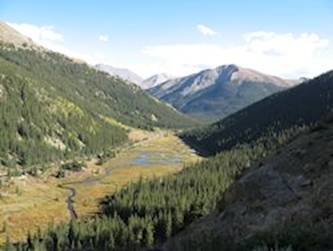 Some of the
As I neared
As expected, it was a hard day but there was the reward of some spectacular scenery on both sides of the pass. Then the campground situation worked out just fine to cap the day.
Day 17: Wed, Sep 17, 2014 - Twin Lakes , CO to Leadville , CO
Today was planned as a short day to Leadville so I wasn’t in
a great hurry to get going. I rode the
little less than a mile back to
I had about 8 miles to the US24 intersection. There were great views of the mountains
behind me with their spots of  From the intersection it was 15 miles and
about 1,1000 feet of climbing which wasn’t too bad except I was still
recuperating from yesterday’s hard climb.
There was almost no shoulder but the road was straight and open so
motorists had plenty of time to see me, plus the traffic was fairly moderate.
From the intersection it was 15 miles and
about 1,1000 feet of climbing which wasn’t too bad except I was still
recuperating from yesterday’s hard climb.
There was almost no shoulder but the road was straight and open so
motorists had plenty of time to see me, plus the traffic was fairly moderate.
I stopped at a food mart a few miles outside Leadville for a
little food and drink and then rode the rest of the way, getting into town
around noon. The neat thing about
Leadville, which at 10,152 feet is the highest incorporated city in the
The hostel was pretty nice and only a few people were there. The only problem was my room was downstairs so I didn’t even try to roll my bike down the steep stairs fully loaded. I removed my rear panniers and didn’t have any particular problem getting the bike with the 2 front panniers down the stairs.
I did a load of wash and then rested in the living room, feeling rather tired. Around 4 pm I walked the 4 blocks downtown and had a calzone of smoked trout at the small Mountain Pies place that did mostly takeout orders. The calzone was advertised for two and when it arrived I didn’t think there was any way I was going to finish it. But I kept eating away and, just like continuing to pedal, I eventually finished it. I felt somewhat better after that so maybe the food or the combination of walking and food made me feel better.
After walking back to the hostel I wrote my notes and did some more planning. Originally I had planned to ride up to Frisco but as tired as I felt I decided to bypass that and head south to the Great Sand Dunes. This was downhill from Leadville and then flat so that should give me additional time to recover from yesterday’s hard climb.
Day 18: Thu, Sep 18, 2014 - Leadville , CO to Salida , CO
It was 36F at 6:30 am when I got up. Packing up was a bit of a hassle since I had to make several trips to haul my bike and panniers up to the main floor. I saw there was another guy in the hostel so it looked like one woman and 5 guys stayed overnight. Then all I had to do was ride downhill 5 blocks to the Grand Burro for breakfast. This was a nice place with some old time charm. I had a good breakfast of pancakes, eggs, and ham.
The goal for the day was to make Salida about 60 miles away. Best thing was it was almost all downhill. Leaving Leadville, I coasted 5 miles before I had to do any pedaling. I didn’t realize it was that steep so yesterday was a harder day than I thought.
After about 8 miles I crossed over the Arkansas River and
followed it down the 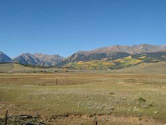
I stopped in
Just after Buena Vista US24 and US285 intersected with US24
continuing east and US285 heading south.
US285 had noticeably more traffic than US24 but it also had a wide
shoulder so the only issue was the traffic noise. About 8 miles from Salida, I took Hwy 291 to
Salida rather than going straight to Poncha Springs. Poncha Springs was the direct route but there
was a climb to
There were a couple of motels along Hwy 291 in Salida but I
continued on until it dead ended at US50 where most of the motels were. I rode west on US50 for a mile or so. I fought off the urge to stop at the first
inexpensive looking motel and continued on to the
There was only one restaurant close to my motel and its menu didn’t appeal to me so I just grabbed a turkey sandwich from the food mart nearby and made a meal of that.
Day 19: Fri, Sep 19, 2014 - Salida , CO
I had a decent continental breakfast at the motel of cereal and oatmeal. On my way out of town I stopped at Walmart which I was told was the grocery store for the area and picked up a few things. By the time I actually left town it was almost 8:30.
It was 4 miles to Poncha Springs where I picked up US285 south. Then I began the 7 mile climb to Poncha Pass at 9,010 feet but this was only about a 1600 foot climb over 7 miles so it wasn’t too bad. I only needed my lowest gear for a couple of sections. After 2 hours I was at the top.
 The
descent into the
The
descent into the
A little while later I discovered the need for the ambulance. I saw a flashing sign and then a long line of stopped vehicles and flashing lights ahead, obviously an accident. Here I figured being on a bicycle was an advantage. I just pedaled along the left shoulder until I got stopped near the accident. There were two ambulances and two helicopters. I figured I could get through on one or the other side around the accident but I was told because of leaking fuel and the helicopters I couldn’t get through. They had started routing vehicles on a dirt/gravel road around the accident site. It was suggested I hitch hike so I pedaled back a few hundred yards and attempted to get a ride.
After about 30 minutes with no luck I pedaled back to the accident site. By that time the ambulances and helicopters were gone but a guy approached waving his hands and refused to let me through. He said he couldn’t let me through and I countered that it wasn’t that he couldn’t it was that he wouldn’t let me through. After I challenged him twice he walked away. I wasn’t sure if he was dismissing me but a few minutes later he came back with a guy from the sheriff’s office. I pointed out I couldn’t get a ride and I couldn’t ride the dusty, congested road. I told him I simply wanted to push my bike up the bank on the right and push along the fence to get around the site. He said “OK, I can let you do that” and I was on my way. The bank was actually very steep and I was having trouble when I guy helped me push the bike the final few feet and then I was able to push through the somewhat brushy area along the fence. It wasn’t hard and I was on my way.
About a mile or two later I stopped in the very small town of Villa Grove and got a cold Gatorade at a small store. As I drank my Gatorade I told the woman what I knew about the accident and when I mentioned the guy who insisted I couldn’t get through she nodded her head and said she knew some of the boneheads (her term) up there.
After that I was on my way. A few miles further I took the turn off on Hwy 17. There was a little descent but then it was flat and straight as far as you could see. There wasn’t much shoulder but there wasn’t much traffic. For a while the road had cracks and I was getting a good thumping as I rode over them and that got pretty tiresome.
When I reached the even smaller town of
So when I reached the turnoff to
Relieved that this wasn’t a bust I pulled in around 4 pm. The tent sites weren’t any great shakes but it was better than having to push on another 30 miles to the Great Sand Dunes National Park and get in late and possibly not be able to get a site. I got a site for $20 and a $0.50 shower and then I had a decent chicken wrap sandwich at the pool which had a small eatery. This place also served breakfast but it wasn’t very useful because it didn’t open until 10 am.
After my tummy was happy I grabbed my PC and walked to the laundry room where I could sit inside out of the sun and tried to connect to the WiFi without any luck. I also tried my phone and that didn’t work either. So I walked to the pool and asked them to reset the WiFi and that seemed to do the trick.
The big news as far as I was concerned was I had finally
figured out how to wrap up my tour. My
original plans were to drop down into
This was a good day for riding despite the hour delay due to
the traffic accident. The climb to
Day 20: Sat, Sep 20, 2014 - Hooper, CO to Great Sand Dunes NP, CO [37.9, 4:07:35, 9.2 mph, 1,138']
I packed up and decided to use the paved route back to Hwy
17 this time. It was almost 3 miles back
to the highway and then just a little further was the town of
When I left it was almost 8:45. I rode south for 7 miles and then took Ln 6 N towards the park. The park didn’t look that far away - maybe 5 miles - but it was more like 15 miles. This road had some cracks in it so I got some thumping out of it but not as bad as yesterday. After what seemed forever the road finally bent to the left and began a little climbing. I stopped at the first campground place near the park entrance but found out it was a private campground so I continued on.
At the entrance I got in with my
I was afraid there might not be cell service in the area but there was so I made arrangements for the Combres & Toltec train ride in Antonito on Monday. I got reasonable rates for two nights at the Narrow Gauge Railroad Inn for $53 each night and the motel also took care of getting my train tickets, $89 with my AARP discount.
 I
ate a little and then set out on my unloaded bike with my little backpack and
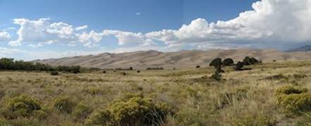
headed to the Dunes. The park didn’t
recommend sandals because the sand can get as hot as 140F during the summer but
I didn’t have an option since I only had sandals. This was okay since it was only in the 70s
today. I walked out to the dunes and up
one small dune. It would have been a
real hike to get to the top of the dunes and I wasn’t up for that. What a number of people were up for was dune
skiing. They had boards much like a
snowboard for skiing down the dunes, but they had to work for their fun since
there were no ski lifts. I hung around
for a while people watching. It was very
windy and the sand was pelting my bare calves.
I
ate a little and then set out on my unloaded bike with my little backpack and
headed to the Dunes. The park didn’t
recommend sandals because the sand can get as hot as 140F during the summer but
I didn’t have an option since I only had sandals. This was okay since it was only in the 70s
today. I walked out to the dunes and up
one small dune. It would have been a
real hike to get to the top of the dunes and I wasn’t up for that. What a number of people were up for was dune
skiing. They had boards much like a
snowboard for skiing down the dunes, but they had to work for their fun since
there were no ski lifts. I hung around
for a while people watching. It was very
windy and the sand was pelting my bare calves.
After maybe an hour or so I rode my bike back to the
After hanging around the
A nice day. The dunes
from a distance are somewhat dwarfed by the
Day 21: Sun, Sep 21, 2014 - Great Sand Dunes NP, CO to Antonito , CO
It was windy off and on all night. That didn’t bother me in the tent. It just made me worry that this might mean that tomorrow would really be windy and make the ride to Antonito hard.
I wasn’t in any real hurry in the morning because I wanted to catch breakfast at the Great Dunes Lodge restaurant which didn’t open until 8 am. As I was leaving the campground big clouds were slipping over the mountains and blocking the sun. At one point a gap opened up and the sun partially shined on the dunes and the shadows were very scenic but that didn’t last long.
I got to the restaurant just a few minutes before it opened. I had a decent breakfast similar to yesterday except the pancakes were about half the size of yesterday and the price a little more expensive, not too surprising just outside a national park.
By the time I left it was almost 8:45. It was easy pedaling because it was a little downhill and, despite my concern, the wind wasn’t an issue. Along the way a woman out for a Sunday morning ride caught up with me and we had a short talk before she took off. She turned around at the end of the road and I got a photo of her riding past, waving.
After 20 miles I reached the end of Hwy 150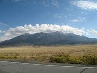 and took US160 west to Alamosa for 15 miles.
US160 was a flat, high speed road but with a huge shoulder. When I reached Alamosa I intended to stop at
a food mart and was hoping to get some pizza.
The first place normally had pizza but not when I stopped so I moved to
another and it was even less attractive.
I figured I had another shot or two but I was wrong and I picked up
US285 south to Antonito without getting anything to eat or drink.
and took US160 west to Alamosa for 15 miles.
US160 was a flat, high speed road but with a huge shoulder. When I reached Alamosa I intended to stop at
a food mart and was hoping to get some pizza.
The first place normally had pizza but not when I stopped so I moved to
another and it was even less attractive.
I figured I had another shot or two but I was wrong and I picked up
US285 south to Antonito without getting anything to eat or drink.
I rode on a frontage road and stopped along a fence by a house where there was shade from a tree and used my food supply for some snacking. There was a dog at the house that could just barely see me because of the fence but he went nuts yapping away nonstop for maybe 10 minutes. I was intent on not leaving until he shut up when the missus of the house finally peeked outside to see what the ruckus was and took the dog in the house. That left me free to continue on to the next town, La Jara.
I had been making good time on first a slight downhill and then a flat road but now started to slow down. At first I thought a little headwind might be the cause but it wasn’t strong enough to affect me much. I finally realized the reason had to be a little uphill from Alamosa to La Jara to Antonito.
When I reached La Jara I didn’t take any chances and stopped at the first, and only, food mart for a bite to eat and a cold drink. After I continued riding the 14 miles to Antonito I noticed that it must be raining just to the west. This rain appeared to be running parallel to the road and never threatened me but appeared to be just keeping pace with me. I could see the clouds just above the road were the nice white cumulus clouds. Sometime later I felt a few sprinkles and looked up and saw the darker clouds had edged over the road. I could also feel that the wind had shifted and that must have moved the clouds further east.
When I reached Antonito it started a little more serious drizzle and I stopped under a restaurant awning to put my maps away. Then the little drizzle stopped and I rode through town to the southern end where the train station was and the Narrow Gauge Railroad Inn. I got my room for 2 nights which cost just a little less than $100 which I thought was a pretty good deal for a tourist attraction. Later I walked back to town to get something to eat and stopped at the train depot to get my train ticket for tomorrow. I ate at a Mexican place downtown and it was pretty good. Then I returned to my motel and prepared for tomorrow.
Day 22: Mon, Sep 22, 2014 - Antonito, CO [Train Day]
The motel had a continental breakfast which wasn’t much but I was going to be riding a train most of the day so I didn’t need much. I was set to ride the train from Chama to Antonito so the first step was a bus ride from Antonito to Chama. We took off at 8:30 on a 50-seater with about 20 people and arrived in Chama at about 9:40. The ride was scenic and made me wish I was riding my bike except not today when the weather was sketchy and drizzling at times.
We only had a few minutes in Chama before boarding the
narrow gauge train for our 10 am departure.
Our car was almost completely full.
The train was about as fast as I would have been on my bike had the
railway been paved. The train really
chugged up the slope to the pass. The weather wasn’t great with clouds and
some sprinkles. The one good thing about
the weather was that it kept a lot of folks in the car. Otherwise there would have probably been a
lot more folks in the open air gondola where I tried to spend as much time as
possible. At about the half way point
the train stopped in Osier for an hour lunch.
Lunch was turkey or meatloaf, or salad/soup bar with a desert bar and
all you can eat. Ironically, on the day
I least needed food I got the most food and it was good food.
The weather wasn’t great with clouds and
some sprinkles. The one good thing about
the weather was that it kept a lot of folks in the car. Otherwise there would have probably been a
lot more folks in the open air gondola where I tried to spend as much time as
possible. At about the half way point
the train stopped in Osier for an hour lunch.
Lunch was turkey or meatloaf, or salad/soup bar with a desert bar and
all you can eat. Ironically, on the day
I least needed food I got the most food and it was good food.
The weather was better after lunch and the sun occasionally peeked through. There was a lot of nice scenery with the train passing above a valley and above a gorge. This was rugged country and the railway weaved every which way to maintain a low grade. In fact, the railway crossed the Colorado/New Mexico border eleven times along the 64 mile route.
Towards the end of the route as it approached Antonito the landscape changed and the hills became more rounded with less vegetation and more sagebrush.
We arrived “home” about 4:45 pm although some of our passengers had to board buses for an hour ride back to Chama which was their “home.”
Since I ate a lot at the all you can eat lunch I didn’t need much food. I grabbed a sandwich at a food mart and that was all I needed.
I spent most of the rest of the time planning my end
game. I made reservations on Amtrak for
Thursday in La Junta where I have been before.
Then I planned out my routes from Antonito to
Day 23: Tue, Sep 23, 2014 - Antonito , CO to Walsenburg , CO
I wasn’t in a hurry.
It was a little cool outside and I expected a fairly easy day. My goal for the day was to ride to
I ate breakfast at the restaurant next door because I wanted more than the minimal continental breakfast the motel offered. They didn’t have much of a menu so I had a standard breakfast and left around 8:30.
I retraced my rout north on US285 for 7 miles and then
picked up Hwy 142 east to San Luis.
After 3 miles on Hwy 142 I passed through Manassa, birthplace of Jack
Dempsey, aka, the Manassa Mauler. Just a little east of Manassa the scenery got
really nice. There was a 3-4 mile
moderate climb through the
Just a little east of Manassa the scenery got
really nice. There was a 3-4 mile
moderate climb through the
About 8 miles from San Luis Hwy 142 turned north for a few
miles but I went straight on a well paved road that connected with Hwy 159 that
took me right into San Luis with the
It was important for me to get something to eat because I
had decided I shouldn’t rule out riding all the way to Walsenburg.
I left San Luis at 12:30 for the 16 miles to
US160 climbed 1500 feet over about 21 miles to La Veta Pass and then descended 27 miles to Walsenburg. So the climb to the pass wasn’t particularly steep and I figured I should be able to make the pass in 3 hours, or by 5 pm. I figured that gave me enough time to descend to Walsenburg before daylight ended.
The first 13 miles had some modest climbing and then a
descent. The real climbing was the 8
miles to the pass. I climbed mostly at 6
mph with a couple of dips into the 5 mph range and there was a short stretch
near the pass where I dropped down to 4 mph. I made the pass by 4:45 pm, a little better
than I had planned.
I made the pass by 4:45 pm, a little better
than I had planned.
The descent was initially pretty steep. I was descending 30+ mph and then I got into
the 40s. At that point I got into a tuck
to see if I could beat my fastest time on this trip which was 45 mph. When I exceeded that I stayed in my tuck
because the road was good and straight and there wasn’t any traffic in my
direction and I had the whole road. I
hit 48 mph but I didn’t think the road was steep enough to break the 50 mph
barrier. Still I stayed in my tuck and I
was sure I was going to bottom out at 49 mph when my display very briefly
flashed 50 mph. Years ago in 1994 I had
an opportunity to break the 50 mph barrier in
After that it was mostly coasting 20+ mph with only a couple of places where I had a slight uphill and had to pedal. Otherwise I only pedaled to maintain speed. In the end I covered the 27 miles from the pass to town in about 75 minutes.
When I entered town I looked for the Anchor Motel that I saw
on Google Maps and got a room for $44.
This was probably the best value of the trip. I had a $40 room in
After cleaning up I walked through the downtown looking for
a place to eat. As with many downtowns
these days this one had seen better times.
I ended up at a
So this turned out to be a very good day. I ended up in Walsenburg and that put me in a better position for catching my Amtrak train in La Junta. The scenery for the most part was very nice and even the climb to the pass wasn’t bad. Then I broke the 50 mph barrier to boot. While this qualified as a century ride I considered it really a 78 mile ride and a 27 mile coast.
Day 24: Wed, Sep 24, 2014 - Walsenburg , CO
I packed up and rode across the street to the Carl’s Jr for breakfast. The motel operator suggested this was the only place close by for breakfast. I had two sausage and eggs biscuit and a cinnamon roll and it was a pretty decent breakfast for $6.
The challenge for the day was the route to La Junta was 72
miles with no services along the way.
The train didn’t arrive until 7:31 pm so there was plenty of time to get
to La Junta. The first 20 miles were
like a bowl, a descent followed by a little climbing but nothing hard. The road was good and there was only an
occasional vehicle so it was good riding conditions. There was virtually no wind. After 20 miles there were 16 wind generators
and only one was moving anywhere like a normal wind generator. The others were barely moving and you had to
stare at them for a few seconds to confirm they were actually moving.
The road was good and there was only an
occasional vehicle so it was good riding conditions. There was virtually no wind. After 20 miles there were 16 wind generators
and only one was moving anywhere like a normal wind generator. The others were barely moving and you had to
stare at them for a few seconds to confirm they were actually moving.
After these initial 20 miles the road mostly descended the rest of the way. Before descending I stopped for my second breakfast where there were a couple of large rocks at the driveway to a ranch since there weren’t many sitting opportunities along the way.
After 50 miles I thought I saw something approaching from
the other way that looked like it might be a cyclist and it was. I met a South Korean who was riding across
the country from
About 10 miles from La Junta the landscape suddenly turned green and there were farms with hay and corn. For these final miles the traffic picked up a bit and the riding wasn’t quite as favorable.
I rode into town at 2 pm and stopped at another Carl’s Jr for a vanilla shake, needing something cold and wet. My Amtrak ticket was set for tomorrow since I hadn’t expected to make La Junta until tomorrow. So I called Amtrak to move my ticket up a day and was rather shocked to learn that it would cost $100 to change. I thought changing would cost something like $50 but I couldn’t see hanging around for a day so I bit the bullet and made the change. After checking out the Amtrak station which I remembered from before I returned to the Carl’s Jr for a bite to eat.
Finally I went back to the station and packed up everything for carrying my 2 rear panniers as a luggage unit and my tent and sleeping bag in a small duffel bag as another unit. I used one of the front panniers for carryon stuff to put under my seat. Then it was a couple hours wait for the train which was about 10 minutes late.
My ticket change not only cost $100 but I could only get a lower level seat. I didn’t expect that would be that much of an issue since I tend to spend a lot of time in the observatory car anyway. The conductor told me to just pick an empty seat and the one I chose was right behind a guy that seemed to have some issues. So I quickly moved a couple seats back to distance myself from him.
Day 25: Thu, Sep 25, 2014 - Naperville ,
IL
My instincts about the guy with issues were well founded. Sometime close to midnight he got into an altercation with the guy in the seat across from him. This guy was a serviceman and probably was suffering from post-traumatic syndrome. Apparently he was moaning or something and the other guy called him out. I thought this was going to end up in a fight but fortunately it never did. This guy had apparently had an incident with someone else in the upper level before I boarded and was told to stay in the lower level. The guy in front of me recorded the conversation on his smart phone.
It took a while for the conductors to show up. They listened to both guys and listened to the recorded conversation. In the end this guy was removed from the train at the next station, Garden City, KS. It was unfortunate that this guy was apparently having PTS issues but it seems he was a problem just waiting to boil over, probably a casualty of one of our continuous wars.
After this was settled, I slept pretty well. Without a seatmate I was able to kind of stretch out across both seats.
In the morning I moved up to the observatory car and spent
most of the rest of the day there. I got
off the train in
It was nice to get everything home without incident and start to get settled again.
Day
26: Fri, Sep 26, 2014 -
With my bike hopefully sitting in Union Station, I walked to
the train station in the morning and caught the 8 am express to Union Station
which took about 35 minutes. I unpacked
my bike and was on the road shortly after 9 am.
It was a nice day for riding but riding on bumpy roads and roads under
repair wasn’t fun until I got to near the end of
![]()

![]()
Copyright
Denis Kertz, 2014. All rights reserved.