Glacier National Park to
Aspen
Fall 2017
Denis Kertz, ©2017
Day 11: Fri, Sep 15, 2017 - Lovell, WY
It was
raining in the morning so it was an easy decision to lay over for the day with
the temperature in the mid-40s. It was just
a light rain that ended in the afternoon and then was supposed to rain
overnight.
The motel had
a continental breakfast that I used. It
wasn’t much but I didn’t need much today.
Later I
walked a few blocks to the library and spent a couple of hours there. Then I watched golf for a good part of the
afternoon.
There was a
Maverik foodmart on the main drag that made their own sandwiches. I had a burrito for lunch and a chicken wrap
for dinner and that was all I needed.
The rain was
supposed to end tomorrow morning so I expected to leave sometime in the
morning. It is only 32 miles to Greybull
so I didn’t need a full day of cycling.
Day 12: Sat, Sep 16, 2017 - Lovell, WY to Manderson, WY [53.4, 5:22, 9.9 mph, +1,645/-1,619']
I wanted a
real breakfast this morning so I stepped outside my door and walked to the end
of the block to the Branding Iron, the only place open for breakfast. They had a sun room that was attractive but I
was told it was a smoking room so I had to go into the other less attractive
bigger, non-smoking room. I ordered the
ham & cheese scramble with a pancake rather than toast. It was a good breakfast.
I packed up
and left at 8 am. The forecast was for
possible rain and it was drizzling just a little when I left and it was in the
low 40s. I wore my tights, jersey, and
long sleeve shirt along with my light windbreaker. I also wore my Sealskinz gloves.
After a few
minutes of warmup this was just about right for the weather except my feet were
cold. So I put on my thin wool socks
with my sandals and that was just about right.
The first 11
miles were mostly a moderate climb until the last couple of miles. Then the next 13 miles were mostly a descent
with one moderate climb. 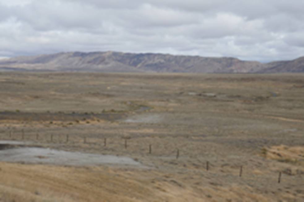 Another
short climb and then a descent brought me to Greybull after 32 miles.
Another
short climb and then a descent brought me to Greybull after 32 miles.
Even though
it was overcast with a little drizzle the scenery was still pretty good through
a shallow valley of yellows and browns and a view of Sheep Mountain. About half way to Greybull the rain totally stopped
and then the sky started lightening up.
By noon I was in Greybull and stopped at a Maverik foodmart and had
another one of their buffalo chicken burritos.
It was way
too early to stop riding but my research yesterday showed there was an RV park
with a cafe just 18 miles down the road at Manderson. I called ahead just to confirm they were open
and then I headed out.
The area
around Greybull and on was now ranching territory. The sky cleared up with white clouds and some
sun and it was pleasant cycling. And
then I felt something and stopped and saw my rear tire was going flat. I removed all the panniers and then the rear
tire. I started checking the rear tire
for anything stuck in the tire and was shocked to find the tire was worn
through in several spots.
My rear tire
was a used tire from a previous tour but I was sure it had more than a thousand
miles of tread left. Obviously, I was
wrong. Interestingly, the worn patches
were in a stretch of about 2 feet and the rest of the tire tread looked
okay. Fortunately, I carried a folding
spare and used it to replace the unusable tire.
The tube was a thorn proof tube but the worn hole looked like it was not
patchable. Rather than take the risk, I
replaced it with a new tube.
This episode
cost me about 30 minutes. I always carry
a spare tire but this was only the second time in about 20 tours that I’ve
needed the spare. The spare takes a fair
amount of space but it’s a real time saver when you need it. Of course, now I don’t have a spare unless I
pick one up somewhere along the way.
This all
happened about 3 miles from Manderson. I
had been debating whether I would continue on another 20 miles to Worland but
this loss of time convinced me to stop in Manderson.
When I called
ahead from Greybull I was told a tent site would cost $20 which seemed a little
high. However, the guy in the bar
charged me $10 and that seemed about right.
The place had a nice clean restroom with a shower, one of the cleanest
I’ve ever been in. After cleaning up I
walked to the cafe for a burrito smothered in chili with French fries. It was good although the burrito was on the
small side.
Day 13: Sun, Sep 17, 2017 - Manderson, WY to Boysen State Park, WY [71.8, 7:10, 10.0 mph, +2,142/-1,149']
The cafe
didn’t open until 8 am on Sundays so I wasn’t in a great hurry to pack up. There was a lot of dew on the tent so I tried
to dry it off as best I could with my chamois.
When I got
all packed up it was 8 am and just time for the cafe. They have a buffet on Sundays so that’s what
I had which was fine. The buffet was a
very reasonable $10.
I left at
8:40. This was going to either be an easy day or a hard day. It was 52 miles to Thermopolis and about 85
miles to Shoshoni. It was a gradual
uphill to Thermopolis with a little up and down. Initially the scenery was great with basic
hills. Once I got close to Worland
ranches started appearing again.
I stopped in
Worland after 20 miles and had a Chocolate Muscle Milk and a chocolate
muffin. I didn’t need much after my big
breakfast but I hoped the muscle milk would fulfill its promise.
Somewhere
outside of Worland I saw a cyclist on the side of the road. It looked like he was fixing a flat so I
stopped to see if I could help and met Clint who was just adding air to his tires. Clint was from Florida and had started from
Whitefish with the intention of riding back to Florida. The other day in Greybull someone saw who I
think was Clint and asked if we were together.
We chatted
for about 20 minutes and I would have chatted more but I knew I was pushing my
luck getting to Shoshoni as it was. I
was sure I had finally found someone slower than me since Clint had started
from Worland and I had managed to catch up with him. So I wished him well and pushed on.
Along the way
I saw a couple herds of Pronghorns, one herd in the field and another right
along the fence next to the road. I also
saw something that kind of looked like a possum cross the road ahead of me but
I couldn’t figure out what it was. Then
I realized later it was a badger, the first badger I think I’ve ever seen in
the “wild.”
It was 3 pm
by the time I got to Thermopolis. That
left 32 miles to Shoshoni which meant at least 3 more hours of riding. I needed a cold drink and rode through town looking
for a food mart. Just when I thought
there was nothing in town I found one at the very southern end of the town
where I had a quick drink and left.
Just outside
town I descended to the opening of the Wind River Canyon and it was
awesome. This canyon was the motivation
for this trip. I’m a fan of the Walt
Longmire mystery books written by Craig Johnson. One of the most recent books was based on
this canyon and I thought this could be an interesting ride. The rest of the route for this trip was put
together with this canyon as the main focus.
There were
high rock walls on both sides of the canyon with a road, the Wind River, and a
railway on the other side of the river. 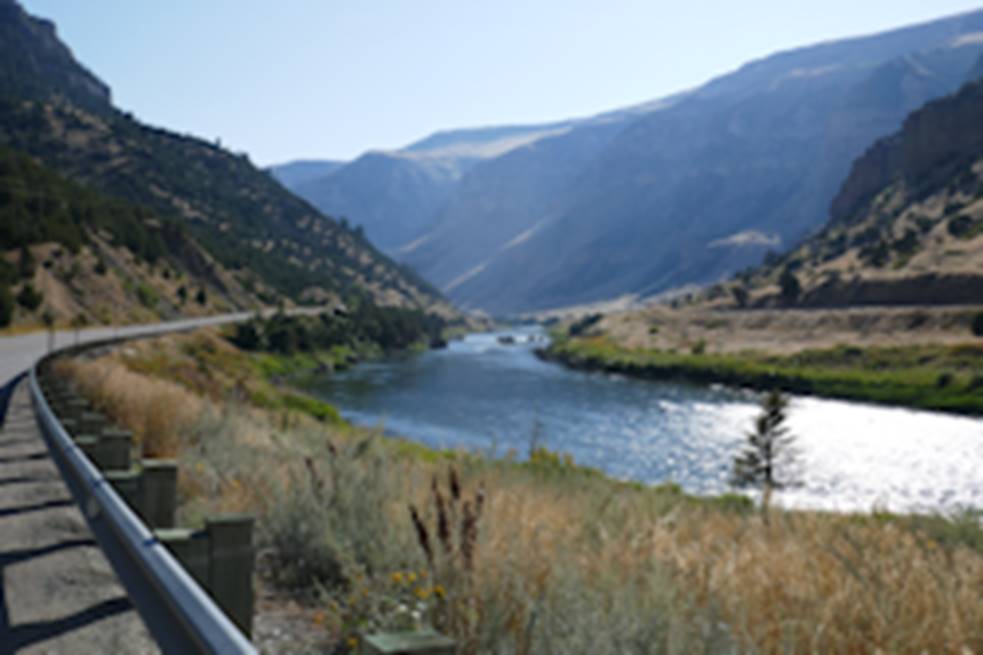 The road was
curvy so there were always new sights. I
had no idea that the canyon would be this spectacular.
The road was
curvy so there were always new sights. I
had no idea that the canyon would be this spectacular.
Eventually
the canyon started widening and it looked like it was about to end but then
another section started up with rock walls.
It was not quite as dramatic as the beginning but nevertheless very
scenic. There were also some tunnels for
both the road and the railway that needed to be cut through the rocky
walls. I stopped to mount my headlight
and turned it and my tail light on as I passed through 3 consecutive tunnels. They were short enough that I could have gotten
by without lights but it was still a good idea to have them.
Just after
the last tunnel I passed by Lower Wind River Campground. At that point it was 5 pm and I still had
close to two hours of cycling to reach Shoshoni where there was a single motel. Since the motel wasn’t a guarantee and I
would be pushing daylight I decided to stop for the night. This was part of the Boysen State Park so I
had to fork over $17 for a campsite as a non-resident. It was nice to be in a campground as part of
the outdoors rather than just a campground as a place to stay in a town.
Since I
didn’t make it all the way to Shoshoni this wasn’t as hard a day as it could
have been but it was long enough as it was.
Day 14: Mon, Sep 18, 2017 - Boysen State Park, WY to Lander, WY [68.9, 7:25, 9.3 mph, +2,263/-1,455']
This place is
apparently a fisherman’s paradise.
Around 7 am a couple vehicles roared into the campsite next to
mine. You would have thought these folks
would have respected that there were other folks in the campground. I was already awake so that didn’t bother me
but the fact that they were just rude did.
I had
breakfast in bed – my cereal breakfast.
Then I packed up and left. In
less than a mile there was another campground.
Then a mile or so further there was the Boysen dam that created the
Boysen Reservoir. There was a good view
of the reservoir from the dam but after that the road veered away from the
reservoir. 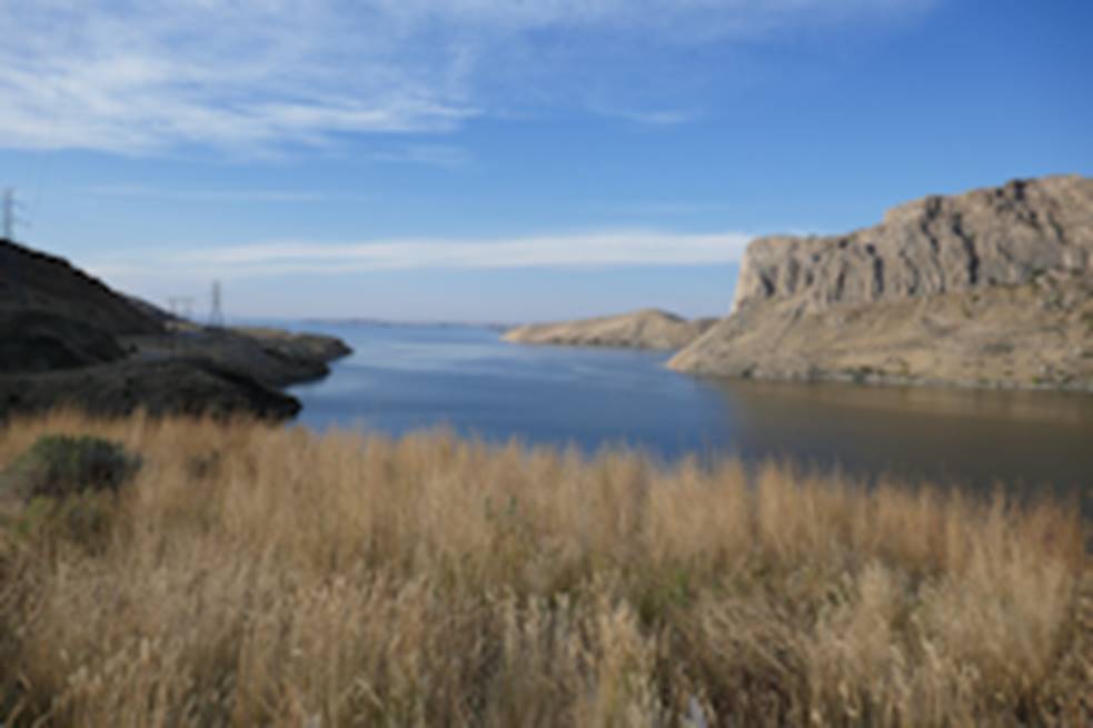 There was
also a sign near the dam that proclaimed the Wind River Canyon was 14.2 miles long.
There was
also a sign near the dam that proclaimed the Wind River Canyon was 14.2 miles long.
It was an
uneventful ride to Shoshoni which turned out to be 15.5 miles from my
campground and took 1.5 hours. So had I
continued on yesterday I would have reached Shoshoni around 6:30 pm, well
within daylight. As it turned out, I was
glad I camped where I did. It was the
first “real” campground that wasn’t just some place to stay in a town.
Entering
Shoshoni there was a billboard advertising the Desert Inn Motel and a
cafe. So I was hopeful about getting a
real breakfast but the cafe was shuttered and for sale. There was a good food mart in town so I made
do with a breakfast sandwich and pastry.
It was 22
miles to Riverton with about a 10-mile uphill stretch that only got fairly
steep the last mile or two. I reached
Riverton around 12:30 and stopped for a bite to eat.
When I left
Riverton, it was almost 1 pm and I had 24 miles to Lander. I figured that would go fairly quickly but I
was wrong. First, as soon as I left town
I got hit by a strong headwind.
Fortunately, that didn’t last very long but then I discovered I had more
climbing than I expected. When I looked
at my elevation profile I realized the vertical dimension was skewed by the
3,000-foot climb to South Pass. With a
normal vertical dimension, I would have seen more of the climbing.
Then on top
of that the shoulders were a problem.
They started out fine but then there were a lot of 2-3 inch cracks where
the crack filler was settled below the top level of the shoulder. So it was a lot of bouncing around while
trying to avoid the cracks. I eventually
spent time in the driving lane when there was no traffic.
The upshot
was I spent at least 3.5 hours covering 24 miles, which was at least an hour
longer than I expected. I eventually
reached Lander just before 4 pm. Normally,
that would have been fine but I was hoping to find a bike shop in Lander where
I might be able to get a backup tire.
I stopped at
a food mart just as I reached the southern end of Lander and the guy in the
food mart told me where a bicycle shop was, just a little
ways into town. Of course that
didn’t mean the bike shop would have what I wanted but I got lucky. The guy in the shop was a touring cyclist so
he understood what I was looking for.
They actually had a 700x35 Schwalbe tire but it cost $80 and spending
that much didn’t make sense for a backup.
They also had a 700x32 Continental Gatorskin tire for $55 that was more
reasonable and a decent backup.
Better yet,
this guy was able to give me information about the area around Atlantic City. In particular, I was concerned whether I would
have to pack extra water for the 75-mile, 3,000-foot climb over South Pass on
the way to Farson. He assured me there
were a couple places I could get water and that Atlantic City was a bailout
option, particularly important given that tomorrow’s weather was uncertain.
I ended up
getting a motel right by where I came into Lander. It was a bit pricy at $79 plus tax but it had
WiFi, or so they said, and a Laundromat.
After cleaning up I walked through town looking for food. There was a restaurant next to my motel that
advertised Monday as Mexican night but I discovered that just meant some
tacos. I continued on looking for a
pizza place but after a while I found a real Mexican restaurant and had a huge
burrito along with chips that satisfied my hunger.
When I got
back to my motel I discovered the WiFi didn’t work. I could connect but web pages wouldn’t
load. Fortunately, the motel restarted
the WiFi and that fixed the problem. I
also did a load of laundry since there was a washer/dryer in the complex.
This turned
out to be a harder day than I expected due to the Riverton-Lander section. On the bright side, there was a fairly fast
descent near Lander and I suddenly noticed that there was no wobble in my front
tire. It was a mystery why this problem
would have just gone away but it was nice to just head downhill without any
vibration. We’ll see if that continues.
Day 15: Tue, Sep 19, 2017 - Lander, WY
When I got up
in the morning it was drizzling slightly and the weather radar was showing a
big glob of green except where it was showing ice/snow at the higher
elevations. I walked next door to the
restaurant for breakfast. Afterwards
there was no weather change so I decided I needed to stay over for the day. However, the problem was that tomorrow was
good weather except that it would be very breezy with the wind 20 mph out of
the southwest – the direction I would head once over South Pass. So that didn’t look good either. The next day’s forecast was for less wind and
change in wind direction but some chance of showers. Not an inviting forecast.
I ended up
walking downtown and spent some time in a coffee shop and then the
library. Later in the morning I noticed
the sun was shining into the library. That
looked good but the wind for the day was not good and was forecast to gust up
to 30 mph, not what I wanted to deal with on a bicycle. In any event, I had earlier signed up for
another day at the motel.
In the
afternoon I walked downtown. I was
thinking about checking out a museum at the other end of town. However, I ran into another bicycle shop –
Gannet Peak Sports. I saw it previously
and thought it was a general outdoor shop with some bicycles but closer
examination showed it was a real bicycle shop, one that converted to a ski shop
during the winter so they adopted a more generic shop name.
The
interesting thing was this guy asked what size tires I used (700x37) and
wondered if I was interested in a partially gravel route to the pass. He pulled out a brochure for the Lander area
and showed how I could take the (paved) road to Sinks Canyon and then pick up a
gravel road to the pass. He noted that
it was mostly a good gravel road that he rides as part of a loop out and back
from Lander and that it would offer some protection from the wind. So I was kind of excited hearing about this
alternative.
When I
continued walking and got to the other end of town I found the museum that I
thought was free actually charged admission.
It wasn’t that much but I’ve never been much of a museum fan so I
decided to take a pass. In the end it
was an almost 3-mile roundtrip.
When I got
back to my motel I checked out the South Pass alternative using
RideWithGPS.com. I use this website to
define routes so I can see the elevation profile. What I discovered was this alternative was 12
miles longer and required 1300 feet more climbing. On top of that it was 19 miles of gravel for
the 42-mile route. That quickly
squelched my interest in this alternative.
I decided I would stick with my 30-mile route with 3000 feet of
climbing.
After
thinking about this for much of the day, I decided my best approach was to
climb South Pass tomorrow morning and make that a day’s ride. There are two B&B’s in Atlantic City and
a BLM campground and it looked like there was a place for food. Then the following morning I would continue
40 miles to Farson when the wind was more favorable. Rain wasn’t expected then before the
afternoon so I might be able to avoid any rain or at least most of it.
Day 16: Wed, Sep 20, 2017 - Lander, WY to Atlantic City, WY [30.8, 5:42, 5.4 mph, +3,874/-1,449']
I wanted to
get a reasonably early start to avoid as much wind as possible so I was eating
breakfast at the restaurant next door by 6:15 am. I had a good pancake breakfast with 2 large
pancakes and bacon and eggs.
I left town
about 7:45 heading east on US287. It was
9 miles of ranches along the foothills of the Wind River Mountains before I
took the turn on WY28 to head up South Pass.
South Pass is famous because it was where the Oregon Trail, the
California Trail, and the Mormon Trail cut through the Rocky Mountains. The Pony Express also passed through here.
It was a
scenic ride to South Pass. The highlight
was the Red River Canyon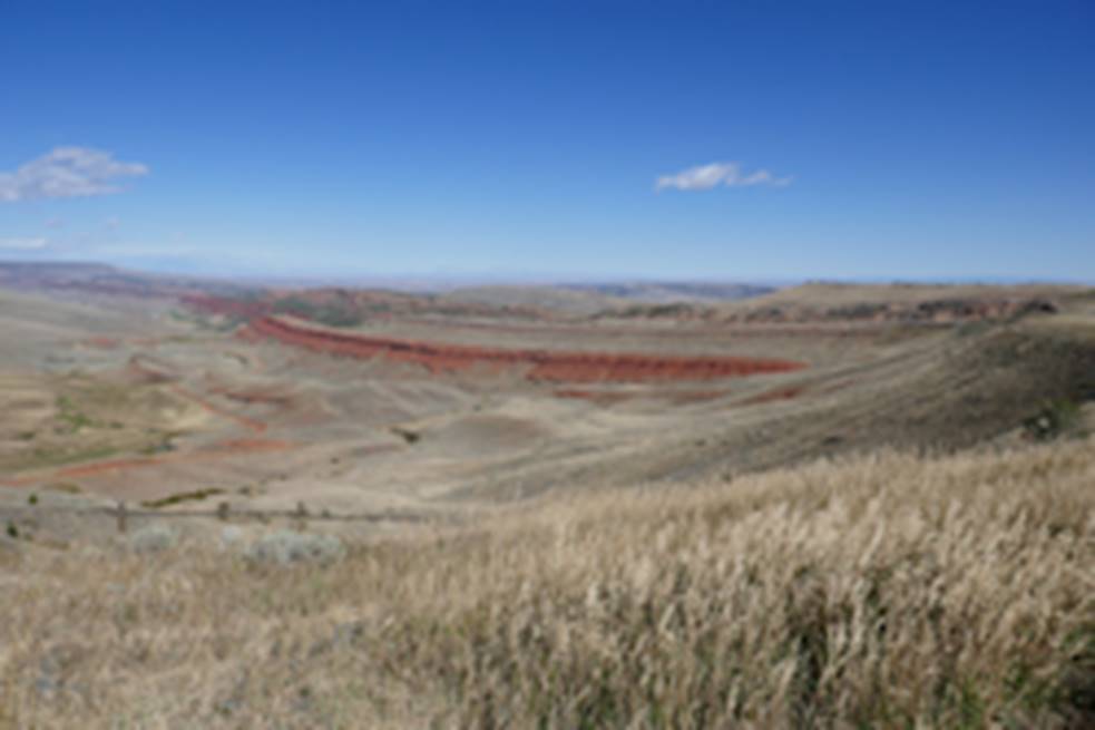 where I also met Greg from Quebec and Bob from New
York City. They were riding the
Continental Divide Trail and got caught in some snow near Pinedale. They ended up getting rescued by Wild Bill
and stayed at his place in Atlantic City last night. Now they were headed to Jeffrey City and
Rawlins.
where I also met Greg from Quebec and Bob from New
York City. They were riding the
Continental Divide Trail and got caught in some snow near Pinedale. They ended up getting rescued by Wild Bill
and stayed at his place in Atlantic City last night. Now they were headed to Jeffrey City and
Rawlins.
At that point
everything looked normal – good scenery and I was making decent time. Then the wind picked up and everything
changed. There was some head wind
previously but nothing that really slowed me up. When the wind picked up climbing became a lot
harder. Then the wind really picked up,
maybe in the 30 mph range and gusting higher.
I usually handle climbs pretty well if slowly but on a long climbing
stretch I stopped numerous times.
Then the wind
became so onerous that it was no longer rideable. I pushed a little to the crest of a long
climb and stopped. It would have been
dangerous to keep riding if even possible.
I also thought I still had 3-4 miles to go and that would have been
impossible with the wind. So I started
thumbing for a ride. I thought folks
might understand the conditions and why I was thumbing for a ride but no one
stopped.
I decided the
crest of the hill might not be the best place to try to catch a ride. Plus, the wind was howling and it was getting
chilly. So I pushed my bike down the
other side of the hill to Beaver Creek where there was a bridge with a guard
rail and tried that. I figured people
would have a better chance to see me and stop.
While looking back up the hill I noticed what looked like a small bush
alongside the road. I didn’t recall that
being there and it looked out of place.
I kept noticing it and I finally saw that it moved a little.
Eventually, I
discovered this bush was a guy pushing his recumbent bicycle which was pulling
a 2-wheel trailer with his dog in it. He
said, and I agreed, that this was the worst wind he had ever encountered. He pulled off into some protective bushes for
some coffee and a break.
I continued
thumbing for a ride. I must have spent a
couple of hours at this without any luck.
Finally, I noticed that the wind didn’t seem as intense as earlier so I
decided to try to make some more progress.
It was probably about a mile to the top of the next hill. Half way up there was a sign that said the
exit for Atlantic City was another ½ mile, much to my surprise.
Buoyed by
that unexpected sign, I pushed on and took the exit. Shortly after the exit, the wind gusted from
the side and almost knocked me over. It
continued very strong and it was all I could do to keep my bike and myself
upright. Finally, I pushed on a little
to get by a small hill. That cut the
wind and then I was okay continuing.
It was about
2.5 miles to Atlantic City which sat in a bowl.
There was a BLM campground in a mile but I had heard that this Wild Bill
guy catered to hikers and bikers so I continued on to Atlantic City. I found his place just on the other side of
town. He wasn’t there but showed up a
short time later, having been out on a wood cutting expedition in preparation
for winter.
He had one of
two B&Bs in town but the Continental Divide guys said the B&Bs were
closed. So I was surprised when he
offered me a 2-bunk cabin with a restroom/shower cabin next door and breakfast
in the morning for $60. This was an
amazing turnaround from just about an hour before when I thought I might be
camping in the bush overnight.
Wild Bill
looked like a wild Bill with white straggly hair and beard but he was all
gentleman. He offered me a drink and we
chatted a little on their deck. Then I
took a shower and when I got back his wife had left some sandwiches for me
which was totally unexpected.
One of the
hardest touring days I’ve had and certainly the strongest head wind I’ve ever
had. I started before 8 am and expected to
be in Atlantic City in early afternoon and didn’t get there until 5 pm. And I ended up in a B&B for $60.
Day 17: Thu, Sep 21, 2017 - Atlantic City, WY to Farson, WY [51.4, 5:33, 9.2 mph, +1,345/-2,405']
I got a knock
on my door just before 7 am that breakfast was ready so I walked down to the
house. I entered a big room that was an
open area with a kitchen, dining table, and a big screen TV with various trophy
heads mounted on the wall. I was
directed to a spot on a kitchen island where I was served pancakes, bacon, and
scrambled eggs along with coffee, just like I ordered yesterday morning in
Lander.
In addition
to getting fed I learned some more about the Wild Bill family lifestyle. They are avid hunters including Wild Bill’s
wife. She is also an avid ice fisher and
said she fishes 2 or 3 times a week during the winter. They also have to drive 28 miles to Lander
for gas for their vehicles so they have to make the trip count when they go. Wild Bill was making antelope jerky and gave
me 2 long strips of jerky to take along on my trip.
I left around
8 and immediately started climbing to get back to the main road. The road was unpaved but generally in good
condition. However, the first hill was
too steep and I ended up pushing my bike up.
I pushed up another short hill that I probably could have ridden but
didn’t want to risk straining my legs after yesterday’s hard effort.
It was almost
4 miles and 700 feet of climbing to get back to the main road. Then I quickly hit double digit speed that I
wasn’t sure I was ever going to see again.
The 40 miles to Farson were essentially downhill but the only
significant downhill part was the first 10 miles or so. There again I marveled how my bike had
rehabilitated itself and tracked smoothly on the steeper downhills.
In the early
part there were some good views of the Wind River Mountains with snow at the
high elevations. Then the landscape
became sagebrush fields as far as you could see with occasional grazing cattle
and some Pronghorns. ![]() The road,
while overall descending modestly, was mostly long undulations with the road
going straight ahead as far as you could see.
The road,
while overall descending modestly, was mostly long undulations with the road
going straight ahead as far as you could see.
There was a
rest stop along the way and I took advantage for a second (cereal) breakfast
because this was likely going to be the only good stopping place along the
way. Otherwise I just pedaled on
enjoying the thrill of double-digit speeds.
I entered
Farson near 2:30 and was surprised to see a town sign noting a population of
313. I had just assumed it was larger
since google maps showed a motel. There
was a town park but it noted that overnight camping was not allowed. I became worried when I didn’t see a motel. It was another 40 miles to Rock Springs which
I didn’t want to have to do because I would likely run out of daylight.
At the
intersection with US191 I rode north a little ways. I saw a place with a cafe sign but it looked
like it was closed. I rode back to the
intersection and got a bite to eat at the food mart. Then I asked about a place to stay and was told
there was a motel just past the cafe. I
rode back to the cafe and, sure enough, there was a motel. I had noticed a pole with 3 rectangular unlit
neon signs with the middle neon sign missing.
I just assumed this was for something no longer around but on this
second look I saw there was a motel sign.
I got a room
for $50 that looked better inside than it did outside. In any event I was happy I didn’t have to
push myself on to Rock Springs. After
settling in I went back to the food mart to get dinner. I was rather annoyed that there weren’t
prices anywhere. It was hard to pick
from the sandwich options without knowing the prices. Nevertheless, I picked a sandwich and some
chips along with a liter of soda and walked back to my room and ate dinner.
Later,
sometime after 6 pm I walked back to the food mart for desert and the sky was
cloudy with some ominous looking clouds with only a few blue patches remaining.
This was a
pretty easy day. The only hard part was
climbing out of the Atlantic City bowl to get back to the highway. After that the shoulder was great except for
about a 5-mile stretch where the road was chip sealed. The chip seal ended just beyond the white
line but some of the chip seal got sprinkled on the rest of the shoulder making
for a rougher ride.
Yesterday the
forecast called for possible rain in the afternoon but nothing appeared
today. However, the forecast for the
next several days all calls for at least 40% chance of rain and even the
potential for some snow showers. So the
future was uncertain.
Day 18: Fri, Sep 22, 2017 - Farson, WY to Rock Springs, WY [42.8, 4:46, 9.0 mph, +797/-1,071']
It was
drizzling slightly when I walked to the cafe next door for breakfast. I ordered a ham & cheese omelet that I
thought was a little expensive at $10 but it turned out to be a fair amount of
food.
When I was
getting ready to leave around 8 am it was drizzling. I had checked the radar and it looked like
the rain was moving north out of the area.
So I waited a bit to see if the rain would move. I finally gave up near 9 am and decided to
hit the road. I put on my rain gear –
jacket, pants, and helmet cover – and also my Sealskinz socks and gloves.
When I left
there were a lot more folks at the cafe.
I was fairly comfortable heading south on US191 to Rock Springs, 40
miles away. Shortly after I left there
was almost no rain and I thought the rain was gone but it came back a little
later.
The route was
harder than I expected. It was a gradual
uphill until about 15 miles to go when it descended to Rock Springs. The scenery was pretty much sage brush like
yesterday until the last 15 miles when hills came into view. ![]()
I entered
Rock Springs at 2 pm and stopped for a bite to eat at the first food mart. Then I rode into town and got a room at the
Cody Motel for $55 that I found through Google Maps. It was a pretty decent room for the price and
it also had a laundromat so I was able to do a load of laundry.
The bad thing
about the motel was it wasn’t located very well for food. There was a Taco John’s nearby so that’s
where I ate. While I was eating it
started raining again. It had also rained
some when I was doing my laundry.
The next
couple of days were still iffy weather wise and then it looked like the weather
was okay for a while as the current cold front finally moves through the area.
Day 19: Sat, Sep 23, 2017 - Rock Springs, WY to Aspen, CO [10.7, 1:20, 8.0 mph, +632/-122']
I walked to
the nearby Taco John’s for breakfast since there wasn’t anything else
nearby. I had what was basically a
scramble bowl and it was fairly decent.
Back at the
motel I checked the weather again and it didn’t look good for the next 2
days. In fact, there was a winter
advisory for Dutch John, UT, my next destination. When it was raining yesterday morning it
occurred to me that I didn’t need to do the rest of this route to Aspen. After the next leg to Dutch John I had
previously ridden the rest of the route.
So the rain and continued cold front triggered me to thinking about
renting a car and driving to Aspen to visit my nephew and family.
Last night I
had checked whether I could rent an Enterprise car. I was interested in Enterprise because there
was a location nearby and Enterprise lets you pick your vehicle, which was
advantageous for picking something to handle a bicycle.
Turns out
there was something messed up on the Enterprise website. It showed 5 locations in Aspen for drop off
but would only allow me to select two of them and when one was selected it said
nothing was available. That didn’t make
sense. This morning I called Enterprise
and the agent said there was nothing in Aspen for drop off, as opposed to the 5
places the website showed. The nearest
drop off place was Glenwood Springs and that didn’t interest me.
So I went to
kayak.com and they came up with an Avis intermediate rental for $250 for drop
off at the Aspen airport. I decided to
go ahead with this and made a reservation for a 10 am pickup. I called my nephew to warn him of my
impending arrival in late afternoon. He
didn’t answer so I left a message. I
guessed he was probably out hunting and had his cell phone turned off. I didn’t have Sabrina’s cell phone or I would
have called her and realized something wasn’t going to work right.
By the time I
was ready to leave it was just after 9 am.
It was 10 miles to the airport outside of town, 2 miles to get to I80, 4
miles on I80, and the rest to the airport on a hill that was a 400-foot climb. I hadn’t counted on a hill, which was a 3-mile
steep climb at 4 mph. When I got to the
airport it was 10:40 and no one was there.
However, there was a number to call and the guy said he would be there
in 10-15 minutes.
When he got
to the airport, he didn’t have an intermediate car available so he assigned me
a Subaru Crosstrek SUV which was perfect.
After folding down the seats the bicycle just fit.
With the
airport sitting on a plateau, there was a great view of the surrounding
area. However, unlike on a bicycle it
isn’t easy to just stop for a photo whenever you want. And when I was riding up to the airport I was
late for my pickup time so I didn’t take the time to really appreciate the
view.
When I made
the rental reservation, a route was suggested, one I wouldn’t have come up
with. At the bottom of the hill there
was a road that went west and dead ended at WY430 which I took south to the
Colorado border. There were fantastic
views along this road and I regretted I wasn’t riding it. There was no shoulder but very little
traffic. It would have been almost
non-stop photos had I been riding.
However, this wasn’t a very realistic route for a bicycle since there
were no services until Irish Canyon campsite in Colorado and I didn’t see any
water sources along the way.
When I reached
the Colorado border the pavement ended and it was replaced by a pretty good
gravel road. The scenery changed
somewhat from rocky outcrops to rounded hill tops with a scattering of trees. Still scenic, especially Irish Canyon, but
not as dramatic as the Wyoming scenery.
Eventually
the road ended at CO318. CO318 skirted
the east side of the Dinosaur National Monument. I was considering riding this road from Dutch
John but the section from US191 to the Colorado border was a gravel road with
some 2,000 feet of climbing. I was
unsure how good this road was for bicycling.
Where I
picked up CO318 was near the turnoff to the Gates of Ladora that lead to a
campground. The rest of the way to the
end at US40 was okay scenery but nothing that would have enticed me to ride the
gravel section. But maybe the gravel
section was more scenic.
I picked up
US40 east near Maybell and then just a little later I picked up county road 57
which I would never have thought about.
It turned out to have some great scenery over the 40 miles to
Meeker. One section was just a fabulous
view of a bowl with the mountains to the west contrasting with some light
colored fields. ![]()
At the
junction of CO64 and CO13 near Meeker, I stopped at a food mart for a bite to
eat. Then I continued south on CO13 to
Rifle where I picked up I70 to Glenwood Springs. This section to Rifle was very scenic as I
remembered it from several years ago when I rode it after a snow/ice storm.
It was 27
miles to Glenwood Springs on the Interstate, which I would have avoided had I
been riding. Glenwood Springs turned out
to be a mess. The normal exit to pick up
CO82 to Aspen was closed because the bridge across the Colorado River was under
construction. Instead there was a detour
from the previous exit across the river and then partway through town before
picking up CO82. This section was fine
for me but it was awful for folks going in the opposite direction. The cars were lined up for a couple of miles
through town. It wasn’t obvious if this
was the normal 4 pm traffic or much worse because it was a Friday
afternoon. In any event, it must have
taken these folks at least 30 minutes to get through town.
It was a
straightforward drive on 82 to Aspen Village where my nephew lives, about 10
miles from Aspen. When I turned off 82
there was a food mart and I filled my rental vehicle with gas in preparation
for the return at the Aspen airport about 6 miles away on 82.
However, when
I got to my nephew’s abode, there was no one around. Calling my nephew resulted in another “leave
a message.” That’s when I suspected
things weren’t going to work out quite right.
I called my nephew’s mother who, of course, didn’t answer. I left a message and then texted her that I
was looking for Sabrina’s cell phone. An
hour or so later she texted back with Sabrina’s cell phone but said they were
camping for the weekend at Lake Powell and guessed they didn’t have cell phone
service there.
The good news
was that my nephew’s garage didn’t have a garage door. It had heavy vertical hanging vinyl blinds
that I just walked through and a motion detector turned on the lights. At that point I realized I was going to be
camping effectively in a large tent.
That wasn’t a problem as I just laid my sleeping pad on the concrete floor
and my sleeping bag on top of it, just like I would have done in a tent. I also noticed that my cell phone battery was
getting pretty low so I charged it up overnight from an electrical outlet. My only complaint was there wasn’t something
like a Lazy-Boy lounger…
Day 20: Sun, Sep 24, 2017 - Aspen, CO [16.6, 1:33, 10.5 mph, +392/-905']
I slept okay
in the garage, just like I was in an oversized tent. I walked down to the food mart only to
discover they didn’t open until 8 am so I had to wait about 20 minutes. Then I had a breakfast sandwich and coffee.
I needed to
return the rental car at the Aspen airport before 11 am so I set up to take
care of that. Since I had nothing else
to do I figured I might as well head into Aspen afterwards on my bicycle and
spend some time there.
When I got to
the airport I returned the SUV without any issue but I discovered my rear
bicycle tire was low. I presumed it was
a slow leak and I debated whether to fix the problem at the airport or wait
until I got “home.” I ended up using my
small portable pump to pump up the tire and hope that would hold the tire until
I got home.
I didn’t know
if it made sense to find the bicycle path into town since I was fairly close so
I ended up just riding the shoulder of 82 into town. In town I wandered around looking for a
coffee shop with WiFi. I found Ink
Coffee and made that my home until mid-afternoon.
Around 2:30
pm I got a call from Nick when they got decent cell coverage around Hanksville,
UT, on their way back from Lake Powell.
I got the house access code and Nick estimated they would be home
sometime around 7 pm.
Not long
after that I left for home, using the bike path. It was basically downhill so an easy
ride. However, I realized I didn’t know
exactly how far I had to go and when I would have to exit the bike path. I knew the exit was something like Gobaz (it
was Gerbaz Way) but I wasn’t exactly sure.
I got a little nervous that I somehow missed the street sign but then it
turned up and I made it back home.
When I left
town I pumped up the rear tire again and just when I exited the bike path I
could feel the tire was too low so I pumped it up again and that got me
home. Then I removed the rear tire and
found a small leak. After patching the
leak, I matched the patch position to the tire position and felt a small wire
inside the tire. That’s why the leak was
slow – the wire was partially plugging the hole.
Around 7 pm,
Nick and the family made it home.
Sometime later Sabrina’s friends from Florida, Bob and Yvonne, arrived
with food. I had eaten earlier so I
didn’t get to take advantage.
Later, Nick
and Sabrina talked a lot about their experience with building their house which
involved a lot of trial and tribulations.
Day 21: Mon, Sep 25, 2017 - Aspen, CO
I got up
early because Genevieve had a school trip to Denver and Nick was going along as
a chaperone. This was a 2-day trip so
this was the last I would see Nick and Genevieve.
Sabrina had a
9 am appointment for her nursing job.
When she returned, Sabrina, Bob, Yvonne, and I took off. We visited Castle Creek. ![]() We also
planned to take the Aspen gondola but it wasn’t running. So instead we rode up towards Independence
Pass and spent some time at the Grotto.
We also
planned to take the Aspen gondola but it wasn’t running. So instead we rode up towards Independence
Pass and spent some time at the Grotto.
Later Sabrina
cooked a meal of elk steaks and a variety of vegetables.
Day 22: Tue, Sep 26, 2017 - Aspen, CO to Glenwood Springs, CO [35.6, 2:46, 12.8 mph, +257/-1,695']
I had planned
to leave around 7:30 am so I could at least see Johnny off to school. It was 32 miles to Glenwood Springs with a
1400-foot descent. Given the train
wasn’t scheduled to depart until 2:17 pm, that was more than enough time to
make Glenwood Springs, have breakfast, and still have at least a couple of
hours.
I had a
cinnamon roll that I had been carrying around for about 2 weeks and a cup of
coffee. When Johnny left to catch the
school bus at 7:30 I went into the garage to retrieve my bicycle and was
surprised to see that my rear tire was flat.
I was sure I had fixed the flat on Sunday after I returned from Aspen
and hadn’t ridden the bike since so I had no idea why the rear tire would be
flat again.
I removed the
rear wheel and pulled out the tube. I
quickly found the leak and patched it.
Of course I had to clean my hands.
Then I loaded my panniers and was ready to go. By this time Bob and Yvonne were up to see
what a real cyclist looked like. They
were amazed that all of my “luggage” fit on the bike. As I started off, I discovered my chain was
not on my rear cog. So I had to fiddle
with it to get it aligned. Then I had to
clean my hands again.
Finally, I
was off at 8:30. This was still plenty
of time to make my 2:17 pm train schedule.
I got on 82 south and then took the Gerbaz Way
exit to get to the paved Rio Grande Trail that goes all the way to Glenwood
Springs. It was a chilly morning at 39F
but the sun was out and it felt okay in the sun and definitely chilly in the
shade.
![]() I had ridden this Rio Grande Trail to Glenwood
Springs once before so it shouldn’t have been a problem. However, somewhere I missed a sign or turn
because I knew the trail crossed over to the west side of 82 and I never made
that crossing. I ended up on a side road
and eventually it crossed to the west side of 82 and I found the trail
again. I missed another turn in
Carbondale but I realized it because I reached 82. So I backtracked a couple blocks and found
the trail again.
I had ridden this Rio Grande Trail to Glenwood
Springs once before so it shouldn’t have been a problem. However, somewhere I missed a sign or turn
because I knew the trail crossed over to the west side of 82 and I never made
that crossing. I ended up on a side road
and eventually it crossed to the west side of 82 and I found the trail
again. I missed another turn in
Carbondale but I realized it because I reached 82. So I backtracked a couple blocks and found
the trail again.
I reached
Glenwood Springs around 11:30. The last block of Main Street was a mess because
it was part of the bridge rebuilding.
There was a pedestrian walkway but it was very narrow and not wide
enough to lock up a bicycle. So I had to
lock up my bicycle at the corner and walk to the Daily Bread where I had a good
ham and cheese skillet.
I rode the
block from breakfast to the train station where I still had a couple of hours
for the train arrival. However, the
train was about 50 minutes late so I had even more time. I got my bicycle tag, cleaned up, and
repacked my panniers so one of my front panniers had my essential and sensitive
items that I could put under my seat.
This time my
boarding was the opposite of my trip start where I was first to board because
they wanted bicycles loaded first. This
time my bicycle got loaded first but the conductor arranged everybody by party
size. Since I was a party of one I was
one of the last to board. By the luck of
the draw I got assigned a seat with another passenger.
As soon as my
ticket was checked I made a bee line for the observation car but it was
completely packed. However, the snack
bar below the observation deck has some tables so I went below and got a table
but the view was not as good as the observation deck.
The initial
scenery leave the station is very dramatic as the train passes through the Glen
Canyon. After that the scenery was not
as dramatic but still very nice. I
stayed below the observation deck until it got dark which was when we reached
Granby. After that I retreated to my
seat, gathered a few things, and made my way to the observation car that had
space on the upper level.
There were
several completely empty seats in a couple of cars to I asked one of the
conductors about changing seats. She
said fine but to be sure to move my seat tag so no one would bother me while
sleeping. I went back to my car and
found someone else had already moved into the couple empty seats. However, I found an empty seat in the next
car. There were seats tagged with CHI so
I knew it would be safe to change cars.
Day 23: Wed, Sep 27, 2017 - Glenwood Springs, CO to Naperville, IL [2.0, 14:00, 8.7 mph, +81/-49']
As usual I
slept with fits and starts. Shortly
after 6 am I basically moved to the observation car for the day. I found a guy was sleeping in the observation
car. I’ve seen that before but this guy
took it to another level – he had his sleeping pad and sleeping bag and was
decked out on the floor. I noticed the
observation car was chilly. Apparently
they weren’t heating it overnight, probably to discourage folks from using it
as a sleeping car. Later I could tell
the car was heated.
The train was
late, mostly due to the fact that it was about 45 minutes late getting to
Glenwood Springs and then there was a 12-mile section where the train was
limited to a max of 20 mph due to some signaling issues. The train was due in at 4:57 pm and made it
around 6:35 pm. This caused some folks
to miss their connections but it didn’t bother me. Bicycles are allowed on the Metra commuter
train but not during rush hour. They
weren’t allowed on the train until 7 pm during the evening rush hour. So I was able to get a quick bite to eat at
the Union Station food court and then get on the 7:40 pm commuter train, the
earliest train I could get my bicycle on.
The problem
with taking a bicycle on the train was that bicycles were confined to the
limited space reserved for handicapped people.
This particularly can be a problem if the handicap person has a wheel
chair of some sort. In this case, I got
on first and two others showed up with bicycles later. My loaded touring bicycle basically takes up
the space for two bicycles. I was a bit
of a nervous wreck fearing that a handicap person would get on at the last
minute and I would get pre-empted. It
turns out a handicap person did get on at the last minute but she didn’t have a
wheel chair so she didn’t pre-empt any bicycles. After the train left, two other bicycles came
on the train but there was just enough room to accommodate them.
It takes an
hour for the night train to get to Naperville because it stops at every station
along the way. This contrasts with the
express train to Naperville during rush hour that only takes 30 minutes. At the Naperville stop I had to carefully
ease my heavily loaded bicycle down 4 steps, using the brakes. Then it was just a 2 mile ride home.


Copyright
Denis Kertz, 2016. All rights reserved.