New Zealand – Haast to Westport
Denis Kertz, ©2000
Day 31: 4/3/2000, Monday
- Haast to Fox Glacier (pop 300) [122.2 km]
I got up
at 7:00 and ate my usual breakfast. I
couldn’t get a newspaper at the store until after 10:00 so I packed up and
stopped next door at the café for coffee.
I was surprised to see they advertised pancakes so I had a couple of
pancakes with my coffee. I figured I
might need a lot of energy today since it was 120K to Fox Glacier although it
was pretty flat except for three successive hills. But true to NZ, the pancakes were thin and marginal.
I set
out around 9:00 and crossed the Haast River on a 1K one-lane bridge that had
two turnout sections. The first 20K
were delightfully easy. Although the
road was close to the sea, the dense foliage and trees hid the beach. Most of the foliage was so dense it was
impossible to see through. At Ship’s
Creek I took an exit to the beach where there was a lookout with two ladders to
climb. The view was good and I thought
this was a nice place. Then the
sandflies introduced themselves and I changed my opinion and pedaled away
quickly.
 Shortly after I started the
three-hill climb. Each hill climbed,
descended a ways and led to the next climb.
Viewing was almost non-existent as the lush foliage hid any views of the
coast except for occasional glimpses.
After the third climb, a turnout at Knight’s Point afforded good views,
giving some justification to the climbs.
Shortly after I started the
three-hill climb. Each hill climbed,
descended a ways and led to the next climb.
Viewing was almost non-existent as the lush foliage hid any views of the
coast except for occasional glimpses.
After the third climb, a turnout at Knight’s Point afforded good views,
giving some justification to the climbs.
After
the descent from the last hill, the road was mostly flat with an occasional
small climb followed by a nice runout.
In a little while the road left the coast and skirted Lake Moeraki,
which was surrounded by forests. At 52K
and almost 1:00, I stopped at a café by Lake Paringa for some food. I was not yet quite half way so I thought I
best eat something. At the café I found
a newspaper that forecasted rain for tomorrow followed by clearing the next
day. It also predicted north winds
today increasing to 35 kph later in the afternoon, something I didn’t need.
When I
started again at about 1:30, I could feel the headwind getting stronger. Fortunately, the road was usually surrounded
by foliage and trees that helped blunt the force of the wind. But when the road broke into the clear, the
headwind was quite strong and I was glad when the foliage returned. Without much of a view other than green
foliage and forested mountains, I started counting down the K’s in groups of
10. I could see that I wouldn’t make
Fox Glacier until 5:00 or 6:00. But the
route stayed mostly flat with some undulation and the headwind eventually
diminished.
When I
was just 10K away, I saw a cyclist ahead taking a photo. It was Suzanne who had continued past Haast
yesterday to Lake Moeraki. We chatted a
few moments and I continued into town, stopping at the Ivory Backpacker. I didn’t get in until 5:30 and got the last
men’s bed, just ahead of a motorcyclist who was not quite fast enough on his
bike. I dumped my equipment, put my
bike in the shed behind the backpacker, and cleaned up.
As I was
leaving, Suzanne showed up to get a room and avoid tomorrow’s predicted
rain. I headed downtown for food and
stopped at a place that had pizza. I
ordered a seafood pizza (salmon, shrimp, and mussels with spinach) that was
very good. Then I retired to a bar next
to the backpacker to write my notes.
Day 32: 4/4/2000, Tuesday
- Fox Glacier
It was a
stifling night in my dorm room of six guys that I was told was a four-bed
room. When I woke up about 4:00 I
remember I left some wash outside on a line.
Since it was virtually certain to rain, I walked outside and hung my
clothes on my bike in the shed that was disturbingly open and unlocked. At the time there were only a few sprinkles.
I got up
at my usual few minutes before 7:00. I
got ready for the day unhurriedly since I was pretty sure nothing opened before
7:30. Shortly after 7:30 I walked
downtown in the drizzle. The store was
open but I found they wouldn’t get the day’s newspaper until 12:30. The café next door where I ate last night
had pancakes on the menu but didn’t open until 8:30. So I walked back to the backpacker to kill an hour. I tried the coin operated Internet machine
that had broken last night. I fed it $2
and got in to my email site but then it locked up and I kissed my $2
good-bye. With the staff back on duty,
I signed up for another day at $16.50.
It was
raining pretty good so I donned my rain pants and jacket even though I didn’t
have far to walk. I had the banana
pancakes and they were the best in NZ by far for $12 with coffee. It was a bleak looking day with occasional
hard rain and no end in sight. I found
a hotel with a working Internet machine so I tried to pay my VISA bill for
March but the machine was ridiculously slow.
It took 20 minutes to check over my bill and then I couldn’t get through
to the site to actually authorize the electronic payment that I needed to do by
4/11. At least I got to check email and
found out who was playing for the NCAA basketball championship.
Then I
killed time for the rest of the day by browsing a store and reading. I finished my paperback and was able to get
another at the backpacker through their paperback exchange system. I also locked up my bike in the shed. I finally got a newspaper and the weather
forecast predicted good weather by tomorrow afternoon as well as on
Thursday. My hope was to see the Fox
Glacier tomorrow afternoon and perhaps Lake Matheson.
I ate at
the café next door and killed the rest of the evening reading. I was encouraged by the glimpse of blue in
the sky along with the upward trend displayed by my watch barometer.
Day 33: 4/5/2000,
Wednesday - Fox Glacier
Up at my
usual time and headed for the Alpine Guides café for a ham & mushroom
omelette, another uncommon NZ breakfast food, which was good. It was a great morning with clear skies, a
complete transformation after yesterday’s awful day. Originally, I thought the morning would be iffy so now my plan
was to see the glacier in the morning and Lake Matheson in the afternoon. The café was in the Alpine Guide and I
talked myself into a morning guided glacier walk. Normally I shy away from these but I justify this at $39 as only
$20 US and not a bad deal. The trip
started at 9:15 so I had plenty of time to gather my things.
At 9:15
I showed up and got fitted with a pair of sturdy hiking boots and socks. We had a group of 32 and 2 guides who took
us in a bus the 6K to the glacier walk parking lot. We split up into two groups of 16, the maximum allowed per guide,
and hiked a short distance to the glacier terminus and then branched off on a
trail along the side of the hill so we could get to an approach point to get on
the ice. This was a fairly steep hike
that took about an hour at a moderate pace.
At one point we had to traverse around a section on the side of a hill
with a sharp drop off. There was a
chain anchored in the rock to hold on to and the guides were very insistent
that everyone held on to the chain even though it wasn’t really very dangerous.
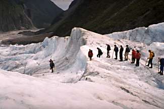 As we descended to the glacier, we
grabbed a walking pole with a metal tip for use on the ice. Then we were instructed how to strap on our
4 point instep crampons we were given when we boarded the bus. The instep crampon fit just ahead of the
boot heel. Then we walked on the ice
following a trail with steps chipped out by guides. Yesterday’s rain had largely washed out the previous trail so two
guides were sent out early to blaze a trail with their ice axes. Our two guides also carried ice axes and
chipped away in places to improve the trail.
As we descended to the glacier, we
grabbed a walking pole with a metal tip for use on the ice. Then we were instructed how to strap on our
4 point instep crampons we were given when we boarded the bus. The instep crampon fit just ahead of the
boot heel. Then we walked on the ice
following a trail with steps chipped out by guides. Yesterday’s rain had largely washed out the previous trail so two
guides were sent out early to blaze a trail with their ice axes. Our two guides also carried ice axes and
chipped away in places to improve the trail.
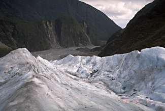
Walking
was pretty easy with a prepared trail and we spent about an hour on the
ice. There were good views especially
looking down the valley with the ice and sheer rock walls carvel out by the
glacier in its past history. After the
ice loop trip, we removed our crampons and gave up our poles for the next
group. Then it was an easy walk back to
the bus and home.
We
completed our trip shortly after 1:00 and I walked back to the backpacker to
plan the afternoon. Reportedly Lake
Matheson was best viewed at sunrise or sunset so I waited until mid-afternoon
before cycling the 6K to the lake parking lot.
I walked the easy loop around the lake in about an hour. There were views of Mt. Cook and Mt. Tasman
but they were somewhat obscured by clouds that had moved in. Lake Matheson has a reputation as the most
photographed lake in NZ because of the reflection of the mountains in the
lake. However, the lake was not quite
calm enough and the cloud cover thickened so I didn’t hang around after the loop
and rode back to town.
I
cleaned up and went out to my favorite pizza place for another seafood
pizza. Not quite as good as the other
day when I was starving but still very good.
Then I retired to the bar next to the backpacker and wrote my notes.
Day 34: 4/6/2000,
Thursday - Fox Glacier
A miserable
day. It was raining when I got up and
the barometric pressure had plummeted which wasn’t encouraging. At 8:30 I donned my rain gear and walked to
the Café Neve for banana pancakes.
However, they weren’t open yet and apparently in no hurry. I hung around because it didn’t look like I
was going anywhere. Eventually they
opened and I had breakfast while reading yesterday’s newspaper, which had an
encouraging weather forecast for tomorrow.
At 9:30
I walked back to the backpacker to plan the day. I thought about checking out and waiting for a weather break in
the hope I could move on even if only the 23K to Franz Josef. In the end I signed up for another day,
which was a good decision as it rained all day. I settled in for another reading day, taking comfort that I could
exchange my paperback for another when done.
I was also entertained by the proprietor’s precocious four-year-old
daughter, Jaime, and their overweight blonde Labrador, Fred, who lazed around
and occasionally sniffed crotches.
I also
used the Internet to break the monotony, making some witty email responses to
friends. I was resigned that I couldn’t
pay my VISA bill on the machine due to some glitch and might have to call VISA
at some point. So I logged on to my
VISA account to get the March bill that I might need to quote to VISA to prove
who I was. After securing that figure,
I clicked the pay authorization button for kicks and before I knew what had
happened I got into the pay screen and was able to take care of the bill.
Around
1:00 I walked over to the Alpine Guide for a real chocolate muffin and
coffee. I browsed the store again and
verified there was no change in merchandise since yesterday. There were also people getting ready for a
glacier walk though I couldn’t image that would be any fun in the rain.
Back at
the backpacker I finished my paperback and traded it for another. I picked up a copy of the book by the “real”
horse whisperer, thinking that might be interesting. I also found a visitor comment book and read a lot of interesting
comments, mostly good, from previous backpacker guests. Comments were from people in Asia, Japan,
Germany, Holland, UK, US, Australia, Denmark, and others. Some comments were written in what was
probably Japanese but most were in people’s best attempt at English. Most were favorable comments, stressing the
homely feeling and pleasant proprietors as well as citing the overweight,
crotch-sniffing Labrador, Fred. An
interesting read in itself, going back more than a year in time.
At dinnertime,
I donned my rain gear for the short walk to the tavern next door for another
fish & chips and beer.
Day 35: 4/7/2000, Friday
- Fox Glacier to Franz Josef (pop 350) [25.4 km]
When I
got up there were some encouraging blue spots in the sky to the west although
it was misting in town. I wandered
downtown for my banana pancakes but the café didn’t open until 9:00 even though
it claimed 8:30. When I finished I had
just enough time to check out by the 10:00 deadline. It was still drizzling some so I decided to hang around town some
in the hope it would clear up. I waited
until almost 12:30 before concluding it wasn’t going to clear up soon. I based that on the low hanging clouds and
that the barometric pressure had been constant all morning. So I donned my rain gear and took off in a
light drizzle, bound for Franz Josef 23K away.
I didn’t figure to make it any further but at least I would be doing
something and would be some place different.
The
route to Fran Josef involved a climb of three hills starting with the first
hill right away. It was a good climb
but didn’t require my lowest gear. On
my descent I had to slow down for a washout area that was being worked on. The second climb was similar to the first
but the last climb wasn’t much by comparison.
While riding it was alternately almost dry and then a heavy
drizzle. As I descended from the last
climb I could see some evidence of clearing with a few patches of blue but
still some troublesome clouds.
When I
pulled into town around 3:00, I had plenty of time to find a place to stay so I
cruised through town and found two backpackers right across the street from
each other. The first one had only six
bed dorms available so I checked across the street where the backpacker had
lots of room. I got a two bed (bunk)
room for $17 and had it to myself. I
unloaded, cleaned up, and headed downtown to check restaurants. I ate chili chicken that wasn’t bad with a
jug of beer at the happy hour price of $5.
Day 36: 4/8/2000,
Saturday - Franz Josef to Okarito (pop 50) [40.7 km]
After a
good night’s sleep, I got up around 7:00 and was packed and gone before
8:00. I went to the same restaurant as
last night because their breakfast menu listed pancakes. As I was paying for breakfast, another guy
came in and asked if I was from Wheaton, the town next to Naperville where I
live. He was a cyclist and was checking
out my Litespeed bike when he saw the SPOKES decal from the Wheaton bike shop
where I got my bike. He and his wife,
now living in Tucson, used to live in the Chicago area. They invited me to join them for breakfast
and we talked about our impressions of NZ.
He had cycled toured a few weeks in NZ while his wife was visiting her
father in Australia and now they were touring via rental car. It turned out to be an enjoyable breakfast
even though the pancakes were so so.
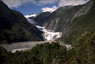
 After breakfast I headed south
about 5K to the Fran Josef Glacier car park.
A short 30-minute walk got me a nice view of the glacier although it
wasn’t real close to the terminus because a river prevented a closer
approach. On my way back to town I
stopped for some groceries because Okarito, a possible stop recommended by the
PP author, didn’t have any food. Then
it was an easy 17K to the Okarito turnoff.
Another 13K along a side road with one pretty good hill brought me to
Okarito. Along the way I saw a cyclist
approaching from the other direction and was surprised to meet Suzanne (who
left Fox Glacier the day of good weather) again.
After breakfast I headed south
about 5K to the Fran Josef Glacier car park.
A short 30-minute walk got me a nice view of the glacier although it
wasn’t real close to the terminus because a river prevented a closer
approach. On my way back to town I
stopped for some groceries because Okarito, a possible stop recommended by the
PP author, didn’t have any food. Then
it was an easy 17K to the Okarito turnoff.
Another 13K along a side road with one pretty good hill brought me to
Okarito. Along the way I saw a cyclist
approaching from the other direction and was surprised to meet Suzanne (who
left Fox Glacier the day of good weather) again.
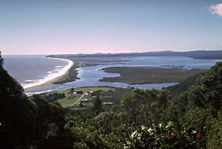
In town
I hiked the 30-minute trail to the Okarito Trig point with some really nice
coast views. It would have also been a
great Mt. Cook view except for blocking clouds. Even though it was early afternoon, I decided to stay over in the
hope the morning would give a clear view from the Trig. I decided on the campground to prove to
myself I was still capable of setting up a tent and paid $5 for a site next to
the beach. I decided to walk along the
beach, which brought me near a kayak rental place so I decided to try kayaking,
something I had never done, on the lagoon.
With a little instruction and a life vest, I was off at 3:00 on my first
kayak trip. I got to explore some of
the lagoon and saw a white heron and a couple of black swans. This turned out to be an enjoyable way to
spend the rest of the afternoon for $30.
After
returning my kayak, I walked back to camp to clean up. The shower had a coin machine for 50 cents
that I didn’t have. However, the shower
came on but very cold so I took a very quick shower. I guessed the coin was to provide a warm shower. After cleaning up, I ate some ever present
cereal and a muffin since there were no cooking facilities in the
campground. Then I hurried to the beach
to just catch the sunset.
After
the sunset, I grabbed my notes and paperback and went to the open lounge
because it had a table and a light.
While there I met two young women from England who came in to cook. They were touring and camping in a $400 car
they bought in Auckland. We had an
interesting conversation as we talked about the things we had seen and done in
NZ. They had already been in Australia
and planned to visit Vietnam and Thailand in their 4.5 month trip.
Day 37: 4/9/2000, Sunday
- Okarito to Ross (pop 450) [103.6 km]
I got up
at 7:00 and packed up some of my stuff and cleaned up. I checked the sky and noted a few clouds but
I could see at least one peak so I took off on the Trig walk. It took about 30 minutes starting from the
campground. When I got to the top, a
long thin cloud obscured Mts. Cook and Tasman.
The cloud wasn’t moving much but my only option was to wait. After almost 30 minutes the cloud partially
dissipated and moved and finally I had an almost completely clear view of the
mountains and the glaciers at the top.
A very good view and worth the trip.
I
returned to camp, ate my usual breakfast, packed up my remaining stuff, and
departed. I retraced my way back to the
main road, getting a good-bye wave from the kayak operator, Ken, as I
left. On the main road it was easy
cycling. I stopped at Whatoroa for
coffee and toast, surprised to see a bunch of locals lounging in the tearoom,
until I remembered it was Sunday.
 From Whatoroa it was another 30K to
Hari Hari, mostly easy cycling except for the Mt. Hercules climb that was
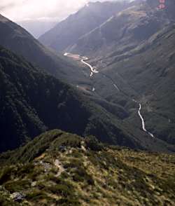
fairly steep but not quite requiring my lowest gear. There were some nice views along the way when glimpses of the
Southern Alps came into view. The best
view was the Whatoroa River running through a valley bordered by big-forested
hills against a backdrop of the Southern Alps.
In Hari Hari I stopped for refreshments and a carrot muffin, probably
the best muffin of the trip.
From Whatoroa it was another 30K to
Hari Hari, mostly easy cycling except for the Mt. Hercules climb that was
fairly steep but not quite requiring my lowest gear. There were some nice views along the way when glimpses of the
Southern Alps came into view. The best
view was the Whatoroa River running through a valley bordered by big-forested
hills against a backdrop of the Southern Alps.
In Hari Hari I stopped for refreshments and a carrot muffin, probably
the best muffin of the trip.
Now the
question started becoming how far to go for the day. It was another 24K to Pukekura whose claim to fame was a huge
sandfly hanging over a café/museum front.
I stopped briefly there but decided to do another 22K to Ross, an old
gold mining town, the last town before Hokitika, another 24K. The road to Ross was more undulating but
still relatively easy. At Ross I
debated continuing to Hokitika but I decided on Ross, which would leave an easy
ride to Hokitika in the morning and then I could decide whether I wanted to
spend the day there.
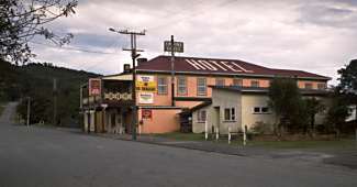
I was
going to camp again but then I saw a backpacker sign at the Empire Hotel. I was pretty sure I could get almost a
private room since Ross didn’t look like a tourist trap. I got a 4-bed room for $15 and had it all to
myself. I was also able to wheel my
bicycle right into the room. After
cleaning up, I took a walk in the historic district that showed some of the
mining techniques, especially the importance of using water in mining
operations. There was a water race
walkway that I followed that led through an old cemetery and up a steep hill,
requiring almost as much climbing on feet as some of my biking. The walk went quite a ways and eventually I
turned back as it was getting late and I didn’t want to have to walk through
the old cemetery after dark.
Back in
town I retired to the hotel bar for food and beer.
Day 38: 4/10/2000, Monday
- Ross to Kumara (pop 370) [61.5 km]
I got up
at 7:30, a little later than normal but a good time since the store didn’t open
until 8:00 when I got some milk for my cereal.
Then I left with still no evidence that anyone other than I had stayed
in either the hotel itself or its 12 backpacker rooms. When I left I saw a sign saying 31K to
Hokitika compared to the 24K my guide claimed.
It turned out both were wrong as it was about 27K, mostly easy riding.
I
arrived in Hokitika just after 10:00 and scouted the town center area looking
for a second breakfast. While looking
around, I saw a familiar figure and said hello to Suzanne again but probably
for the last time since I doubt she was going to Arthur’s Pass. Hokitika’s claim to fame was its jade
carving and glass blowing. I looked
over some of the work and checked out the flat beach. I also took care of some email.
I stumbled across the Masters golf tournament on TV when I walked into a
bar looking for a restroom. Got to see
VJ birdie the 18th hole and win the tournament.
Around
2:30 after spending about 4 hours in Hokitika, I headed out. I wanted to make Kumara to reduce tomorrow’s
ride to Arthur’s Pass. I thought it was
25K but it was almost 30K. However, the
23K to Kumara Junction were flat with a tailwind so it was easy cycling. At the Junction I headed east on SH 73,
another 7K to Kumara. From there it
would be 72K to Arthur’s Pass Village tomorrow.
 My guide listed only a hotel and
motel for accommodations so I asked about a backpacker when I got an ice cream
at the only store in town. The guy told
me no backpacker but suggested I might be able to camp on a sports field
nearby. The nearby hotel had a beer
garden sign with a bicycle on top of the sign so I thought that was worth
checking out. They had no backpackers
or camping but a room was only $20. It
turned out to be much like a backpacker without kitchen facilities. In effect it was a private backpacker with a
single bed and a shared bathroom so I was happy.
My guide listed only a hotel and
motel for accommodations so I asked about a backpacker when I got an ice cream
at the only store in town. The guy told
me no backpacker but suggested I might be able to camp on a sports field
nearby. The nearby hotel had a beer
garden sign with a bicycle on top of the sign so I thought that was worth
checking out. They had no backpackers
or camping but a room was only $20. It
turned out to be much like a backpacker without kitchen facilities. In effect it was a private backpacker with a
single bed and a shared bathroom so I was happy.
The
proprietress, kind of a version of the Southern Woman decked out in a sports
bra and camouflage pants with a nose ring, got my room key that was on a key
chain. It proved difficult to extract
the single key so she just gave me the entire key chain. I took this to mean she didn’t expect a lot
of customers, at least this time of year.
I
wheeled my loaded bike into a lobby area and after carrying my panniers to the
2nd floor room I carried the unloaded bike up as well. After cleaning up, I ate fish & chips at
the tearoom down the street. Then I
retired to the bar in the hotel for a beer and my notes.
Day 39: 4/11/2000,
Tuesday - Kumara to Arthur's Pass (pop 80) [72.4 km]
Even
though my bed wasn’t the best, too soft, I slept pretty well, knowing I owned
the 2nd floor. When I got up
I walked to the store for milk for my cereal, unlocking the hotel so I could
get out. I had my usual breakfast. I was in no hurry to leave and finally left
just before 9:00.
Initially
the road was undulating and I made good time in the clear, cool morning with
temperatures of 11C in the shaded road.
After about 10K, the route changed noticeably and I spent most of my
time in my lowest gears as I began a gradual climb through the Taramakau River
valley. After 40K, I stopped in Jackson
for coffee and toast and a little rest of 20 minutes. Then I took off for Otira, another 19K with more of the same
terrain. I stopped at Otira for a
sports drink and energy bar for some last minute energy for the upcoming climb.
Shortly
after leaving Otira, the climb became significant but not the very steep climb
my guide promised. But I didn’t have to
wait long and I entered the Otira Gorge and began the most difficult climb in
my touring life. The road was so steep
that I couldn’t manage more than 50-100m before my legs gave out and I had to
rest. Over a 1K stretch I must have
stopped 10 times. This stretch was so
steep that big trucks going in the other direction were geared down so much
that they weren’t going much faster downhill than I was going uphill. They had to inch along because there was no
hope if they got out of control.
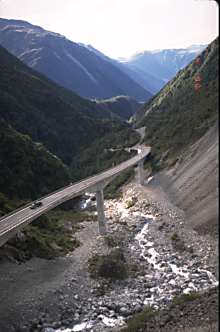 This 1K steep section of the road
was under widening construction to permit two-way traffic. Currently, it was limited to one way with
traffic lights at the two ends controlling the traffic flow. I navigated through this traffic as best I
could. A couple of times I couldn’t
even get started on my bike due to the steep gradient. Once I had to push my bike a short distance
to get to a less steep section. Then I
knew why bicycles are called pushbikes in NZ.
Until last November, this road used to be even worse with a steep zig
zagging section that was replaced by a more reasonable viaduct. I thanked NZ for spending the $25M for
this. Later I learned that it was 1.5K
from the light marking the start of the one-way section where it became very
steep to the end of the viaduct. The 1K
steep section averaged 13% grade but was as high as 17.5%. The viaduct was 440m at 11.7% grade.
This 1K steep section of the road
was under widening construction to permit two-way traffic. Currently, it was limited to one way with
traffic lights at the two ends controlling the traffic flow. I navigated through this traffic as best I
could. A couple of times I couldn’t
even get started on my bike due to the steep gradient. Once I had to push my bike a short distance
to get to a less steep section. Then I
knew why bicycles are called pushbikes in NZ.
Until last November, this road used to be even worse with a steep zig
zagging section that was replaced by a more reasonable viaduct. I thanked NZ for spending the $25M for
this. Later I learned that it was 1.5K
from the light marking the start of the one-way section where it became very
steep to the end of the viaduct. The 1K
steep section averaged 13% grade but was as high as 17.5%. The viaduct was 440m at 11.7% grade.
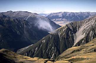
In the
midst of all this agony was gorgeous scenery as the road wound its way up the
Otira Gorge with steep hills on both sides.
Near the top, views of mountain basins were awesome. Equally fine was a view looking down the
Gorge from a lookout above the viaduct.
This was great scenery but this was one time I wasn’t sure it was worth
the incredible effort.
Finally
I reached the pass, 922m, and was able to relax and enjoy the scenery
more. But it was a steep, winding 4K to
the village and I wasn’t sure I could cycle back up without having to stop on
my return. This reinforced an idea I
had previously to take the train to back to Greymouth on the return trip. In Arthur’s Pass Village I found a
backpacker with three rooms that were already almost filled at 4:00. So I decided to use my tent in its back yard
instead for $9. I set up camp and made
a quick trip to the park visitor center before it closed at 5:00.
Afterwards
I started checking out eating establishments, picked up some food for
breakfast, and cleaned up. Then I
checked in with the backpacker hostess who only showed up at 10:00 am and 5:30
pm. I queried about the train and was
cautioned that this was school holiday week which explained why I had been
seeing so many kids around. The hostess
was kind enough to look up the Tranz Rail phone number so I could make a
reservation on the train.
I walked
to the nearby store and grabbed several salmon sandwiches along with chips for
a quick meal followed by an ice cream desert.
Then I adjourned to a nearby café for a beer.
Day 40: 4/12/2000,
Wednesday - Arthur's Pass
I got up
at the usual time and had my usual breakfast.
My plan was to do the Avalanche Peak hike going up the Avalanche Peak
track and returning via the Scott track, both starting near the village. This trip was estimated as a 6-8 hour
roundtrip. A trip description from the
visitor center made the trip sound somewhat dangerous with an indistinct trail
in places. In truth the trail climbed
about 1100m and was very steep in places but there was never any doubt about
the trail. Of course, in bad weather
the situation could have been entirely different.
 After I registered my “intention”
at the visitor center that would summon a rescue effort if I got in trouble, I
started the hike. The first part of the
trail climbed through the beech forest for the first hour before leaving the
bushline. Then it followed a ridge
through the tussock and subalpine vegetation.
Once leaving the bushline there were great views looking down through
the Bealey Valley. After just a little
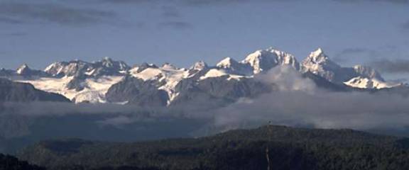
over two hours I reached Avalanche Peak with superb 360 degree views including
a view of Mt. Rolleston (2nd highest peak in Arthur’s Pass National
Park) and the Crow Glacier although clouds were obscuring part of the Mt.
Rolleston peak most of the time.
After I registered my “intention”
at the visitor center that would summon a rescue effort if I got in trouble, I
started the hike. The first part of the
trail climbed through the beech forest for the first hour before leaving the
bushline. Then it followed a ridge
through the tussock and subalpine vegetation.
Once leaving the bushline there were great views looking down through
the Bealey Valley. After just a little
over two hours I reached Avalanche Peak with superb 360 degree views including
a view of Mt. Rolleston (2nd highest peak in Arthur’s Pass National
Park) and the Crow Glacier although clouds were obscuring part of the Mt.
Rolleston peak most of the time.
After
about 30 minutes on the peak where I met another hiker from England, I started
my descent via the Scott Track down another ridge. This descent was steep in places but less so than the ascent and
was favored for the descent for that reason.
As usual the descent was hard on the knees but I made it in a little
less than two hours giving a roundtrip of about 4 hours, not including summit
time. A rewarding trip.
When I
got back, I cleaned up and threw my clothes in the washing machine around
1:00. Then I headed across the street
for lunch and noticed two touring bikes outside the café. I ordered seafood chowder (very good) and
spotted the cyclists, Karl and Karn (KK), a brother/sister combo from Ann
Arbor, Michigan. Of course, I had to
ask them about climbing Arthur’s Pass and we reminisced about this most
difficult of climbs. KK were touring NZ
as part of a trip started in January that included Vietnam but now wished they
had more time to spend in NZ. We
discussed our trips and things that cyclists talk about (e.g., food) and had an
enjoyable hour visit before they left to get situated.
I went
back to take care of my laundry. After
hanging my laundry, I stopped by the visitor center to cancel my intention and
looked over the center more thoroughly.
Back at the backpackers I read the newspaper and saw KK show up where
they decided to stay. Near 5:00 I
stopped at the store for another makeshift meal of beef log and salmon sandwich
and bought a couple of beers for later.
Day 41: 4/13/2000,
Thursday - Arthur's Pass to Greymouth (pop 10,000) [0.0 km]
Even
though the train pickup wasn’t until 11:30, I still got up at the usual
time. After breakfast I laid around a
bit then went out to my tent and packed up.
Then I killed some more time by having coffee and reading a newspaper at
the store. Finally, I wheeled my bike
to the train depot to wait for the train.
I was glad I wasn’t cycling as my legs were sore from yesterday’s hike
and there was a headwind. At the depot
I met my first and only French person of the trip, a young woman who had also
stayed at the backpacker. When the
train arrived, I wheeled my bike to the last car, the cargo car. I was given a boarding pass and had a
four-person seat all to myself.
The
Tranz Alpine Express was billed as one of the world’s great train rides but it
skirted all the great pass scenery as it immediately went through the 8.5K
Otira Tunnel. Prior to the tunnel
opening in the 1920s, passengers from Christchurch had to disembark at the
Arthur’s Pass Village and take a coach over the pass and catch another train on
the other side. When we exited the
tunnel, there was some good scenery but the tunnel hid the best scenery. It was also fairly overcast as well and that
didn’t help.
At
Jackson the train deviated from my ride route to go past Lake Brunner that was
reputedly a more scenic route although it wasn’t obvious to me. At 1:30, two hours later, the train pulled
into Greymouth and I collected my bike.
I messed around a while trying to find the Neptune Backpacker that KK
had recommended but I finally found an info center and they pointed me in the
right direction. Neptune didn’t
advertise yet, apparently getting referrals from another backpacker when it was
full, so it was quiet and peaceful. I
signed up for a single at $25 but I probably would have effectively gotten a
single even with a dorm room as there were only a few people staying at this
backpacker.
KK had
recommended the Monteith Brewery tour so I asked the proprietors. It turned out the last tour was at 2:00 and
it was almost 2:30 already. So the host
called for a reservation using his cell phone (he knew the number by heart) to
arrange a 10:00 am Friday tour.
However, they don’t run tours on Friday so they agreed I could join the
current tour in progress. It took about
10 minutes to walk to the brewery and I missed the tour through the brewery
itself but got in on the tasting part where we sampled 5 different varieties,
all pretty good. We got a ½ glass of
each and then were free to drink whatever at our discretion but I didn’t drink a
lot because I needed to take care of other matters.
So I
wandered back to scout out the town center.
I already had a place to eat since the backpacker told me about the $3
all-you-can-eat BBQ at a local hotel but I needed to find a bike taillight, a
cash machine, an Internet PC, and a breakfast place. After much scouting around I finally found a café with pancakes
and found a grocery store. I also
bought a couple more rolls of film.
At 5:30
I arrived early at the BBQ place to use an Internet kiosk in the bar area. Initially it was hosed but then came back to
life. However, it proved to be flaky
and I finally gave up on it after it locked up a couple of times. A guy in the bar told me the BBQ was
sausages but for $8 you could get steak so I signed up for that. The steak wasn’t bad for the price but it
wasn’t all-you-can-eat steak, only sausages.
I had several more sausages that were good but I was limited because I
can only eat so much sausage before my stomach complains. But I also learned something. In NZ BBQ doesn’t mean the same thing in the
US. BBQ really means just grilled in NZ
and is not accompanied by the traditional BBQ sauce one expects in the US.
When I
left to return home, I stopped at the info center on the way where there was
another Internet kiosk. Unfortunately,
it used Netscape and wouldn’t let me into my email because it complained that a
security certificate was outdated. So I
ended up wasting about $4 on two kiosks with nothing to show for the money. Which is why I dislike kiosks. If they didn’t work, you were out of luck.
Day 42: 4/14/2000, Friday
- Greymouth to Punakaiki (pop 40) [46.9 km]
I got up
later than normal at almost 7:30, probably because the curtains in my room kept
the light out. I walked downtown and
had a pancake with yogurt and sliced bananas that was OK. Then I stopped at the grocery for a few
things and walked back to the backpacker where I augmented breakfast with some
cereal. I retrieved my bike from the
locked Laundromat outside and packed up.
When I left my room key, there were three other room keys left as well.
I cycled
downtown and stopped at a bike shop. My
rear-flashing reflector had loosened and dropped off on the way to Arthur’s
Pass and I was looking to replace it. I
was annoyed because I had noticed it was loose earlier but had forgotten to
tighten it. But I couldn’t find a
suitable replacement at either of the two bike shops. Failing at that, I stopped at the library across the street at
its 9:30 opening to use their Internet PCs that the backpacker proprietor told
me about. It cost $3 for 15 minutes and
I took care of my email in two sessions.
When I
woke up the sky was cloudy and it was windy.
By the time I left, the sky was clear.
I headed out of town, crossing the Greymouth River. For the first 11K, the road was inland but
then rejoined the coast. There were
nice coastal views for the next 20K as the road hugged the coast and large
hills hemmed in the road. Other than
for a couple of fair hills, the road was undulating and easy pedaling. Then the road crept inland for 1-2K until
near Punakaiki. The last 10K was easy
enough and I was able to use my big chainring most of 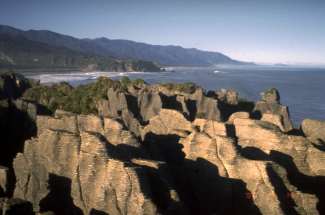 the way.
 Near Punakaiki, the road returned
to the coast again and I stopped at the Pancake Rocks area where there was a
visitor center and a couple of cafes.
The café had some great marble muffins with almonds. I had one and it was so good I invoked
muffin rule #1: if one is good, two is better.
I checked out the visitor center and took the Pancake walk, a short
20-minute roundtrip. The pancake Rocks
are so named because they are formed from stacks of limestone rocks and the
rocks are etched with grooves that make them look like pancakes stacked on top
of each other. Reputedly the rocks are
most spectacular at high tide when the waves crash through blowholes.
Near Punakaiki, the road returned
to the coast again and I stopped at the Pancake Rocks area where there was a
visitor center and a couple of cafes.
The café had some great marble muffins with almonds. I had one and it was so good I invoked
muffin rule #1: if one is good, two is better.
I checked out the visitor center and took the Pancake walk, a short
20-minute roundtrip. The pancake Rocks
are so named because they are formed from stacks of limestone rocks and the
rocks are etched with grooves that make them look like pancakes stacked on top
of each other. Reputedly the rocks are
most spectacular at high tide when the waves crash through blowholes.
It was
early afternoon, around 2:00, and I debated moving on but decided to stay and
relax. I had a choice of a backpacker
or motorcamp and chose a tent site at the motorcamp for $8.50. After setting up camp, I wandered up the
Potari River a ways and then retraced my way back to the river mouth and walked
south along the beach. I started a new
paperback and waited for the sunset that was nice but not spectacular. Walking back to camp, I cleaned up and walked
to the nearby tavern for food – seafood and beer. The tavern was the IN place, probably because it was the only
place. It was full when I left at 9:00
and went to the camp lounge to read until 9:00.
Day 43: 4/15/2000,
Saturday - Punakaiki to Westport (pop 4,500) [84.5 km]
 I woke up and packed at the usual
time. I biked the 1.5K back up the hill
to the café for a breakfast of banana pancakes at about 7:45. Afterwards I took another tour of the Pancake
Rocks and then left. Shortly after
leaving there was a steep 2K climb at Perpendicular Point that had a great view
of the coast at the top. Looking north
was really great, seeing the rugged, irregular coastline with rocks just off
the coast. A cloudy mist gave it a
haunting look.
I woke up and packed at the usual
time. I biked the 1.5K back up the hill
to the café for a breakfast of banana pancakes at about 7:45. Afterwards I took another tour of the Pancake
Rocks and then left. Shortly after
leaving there was a steep 2K climb at Perpendicular Point that had a great view
of the coast at the top. Looking north
was really great, seeing the rugged, irregular coastline with rocks just off
the coast. A cloudy mist gave it a
haunting look.
The road
hugged the coast for the next 15K with steep hills on the right. This section was the best coastal scenery on
the West Coast by far. After 18K the
road turned inland a bit to climb three hills over an 11K stretch. The first hill was 4K, the second 1.5K, and
the last a short 0.3K. Then I descended
to Charleston where I stopped at a café for refreshments. Here I met another cyclist from Montreal
heading in the other direction. and we exchanged travel information.
Leaving
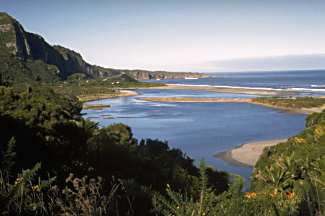
Charleston was one large climb then relatively easy the rest of the way. After 48K, I took a side road to Cape
Foulwind and Tauranga Bay where there was a fur seal colony. When I reach the bay I stopped at a café to
get rejuvenated as I was getting tired.
I had some garlic bread and a Coke that did the trick. The seal colony was on the other side of the
bay with a short walk to the watch area.
I saw about 10 seals sunning themselves.
At 3:00
I left the bay for Westport where I hoped I could find a bike shop on a
Saturday afternoon. It was an easy,
flat 14K to Westport after an easy 1K climb out of the bay. Just before 4:00 I pulled into Westport and
cruised the main street. I found two
bike shops but they were already closed.
I stopped for an ice cream and got directions to the Trip Inn Hostel
that the Montreal cyclist had recommended, an old house converted to a
hostel. I got a $15 room in a 6-person
room where I was the first person assigned.
After
cleaning up, I walked a few blocks to downtown to scout out dinner and
potential breakfast. I stopped in a bar
for a beer and wrote my notes. Then I
walked across the street to a grocery for milk in the morning. Down the street I stopped at a Chinese
takeaway for shrimp and cashew and walked back home. The Chinese food was great and I read the rest of the evening.
![]()

![]()
Copyright
Denis Kertz, 2000. All rights reserved.