New Zealand – Westport to Wellington
Denis Kertz, ©2000
Day 44: 4/16/2000, Sunday
- Westport to Murchison (pop 600) [101.0 km]
Up at
the usual time and usual breakfast. I
packed up and headed downtown where I had coffee and a muffin at a
takeaway. Then I stopped at a grocery
store for some cereal. I also got
another soap dish, the 3rd one of the trip. For some reason I can’t seem to hang on to
my soap dishes.
I
finally left about 9:30 and crossed the Buller River that I would see a lot of
as I followed the Buller Gorge to Murchison.
I followed the sign to the left that said 95K to Murchison. The first 50K went fast as the road was
mostly flat. The morning started out
cloudy like it could get worse but by late morning most of the clouds disappeared
and it was a beautiful fall day.
When I
pulled into Inangahua at 50K, the gorge had opened into a valley with some
farms and I could see some fall foliage.
I stopped at the only store in town (population 50) for refreshments
just after noon. Inangahua’s claim to
fame was the 7.0 Richter scale earthquake in 1968 that hit the area. Next to the store was a little museum
reliving the events so I visited on my break.
Immediately I became the captive audience of the woman in the place,
something I could have done without.
Finally she relented and I made a quick visit and beat a hasty retreat.
Intriguingly,
there was a farm hostel nearby where I considered staying. But it was a nice day for cycling and not
quite 1:00 so I pushed on to Murchison.
Within about 10K the road crossed to the north side of the river that
made it harder to see the river and hid the sun as the hills became
higher. This also marked the start of a
fairly long climb but the only major one of the day. Along the way I passed a section of the south hillside that had
avalanched and dammed the river during the earthquake. The river was no longer dammed but the scar
on the hillside remained.

 11K from Murchison the gorge ended
and broadened into a valley surrounded by large hills. However, in contrast to the thickly forested
green hills of the gorge, these hills had patches of trees and scrub
coverage. The result was a much more
scenic view compared to the somewhat monotonous steep green hills of the
gorge. These last 11K were virtually
flat and easy cycling into Murchison.
11K from Murchison the gorge ended
and broadened into a valley surrounded by large hills. However, in contrast to the thickly forested
green hills of the gorge, these hills had patches of trees and scrub
coverage. The result was a much more
scenic view compared to the somewhat monotonous steep green hills of the
gorge. These last 11K were virtually
flat and easy cycling into Murchison.
I
stopped at the visitor center and got directions to the Kiwi Park where I got a
nice two-person cabin for $15. After
cleaning up, I walked the almost 1K back to town to a restaurant with an
Internet kiosk where I checked email and had lasagne that was good but too
little. More importantly, this place
had pancakes and oatmeal on the breakfast menu. I left the restaurant and stopped in a bar for a beer and to
write my notes.
Day 45: 4/17/2000, Monday
- Murchison to St. Arnaud (pop 200) [66.9 km]
When I
got up it was drizzling lightly and very cloudy and didn’t look good. I decided it was a morning for a leisurely
breakfast so I donned my rain gear and cycled the 1.3K to the restaurant I ate
at last night. I ordered the pancakes
and coffee. I had two large pancakes
that were very good as I read the paper.
The weather forecast looked shaky for Tuesday and Wednesday but not
nearly as shaky as the US stock market.
The
drizzle stopped and there were a few blue spots in the sky. I rode back to my cabin and packed. By the time I left at 9:45 a lot of clouds
had cleared out although there were still a few low lying ones hanging around. Leaving, I rode into a nice valley. I noticed signs of clear cutting in the
hills where evergreen trees had obviously been planted to cover the
clearcut. It was obvious because the
planted trees were in regularly spaced rows and they were distinctively greener
than the surroundings.

 At 40K I reached Kawitiri Junction
and went right towards Nelson Lakes, another 25K. The scene broadened into a nice, long valley of about 20K, mostly
flat with a gentle climb. I saw lots of
sheep, something I hadn’t seen much of while on the West Coast. The Buller River crept through the valley
all the way to Lake Rotoiti at St. Arnaud.
The last 5K looked to be downhill but my lower gear and pedaling effort
were not deceived nor was my watch altimeter.
At 40K I reached Kawitiri Junction
and went right towards Nelson Lakes, another 25K. The scene broadened into a nice, long valley of about 20K, mostly
flat with a gentle climb. I saw lots of
sheep, something I hadn’t seen much of while on the West Coast. The Buller River crept through the valley
all the way to Lake Rotoiti at St. Arnaud.
The last 5K looked to be downhill but my lower gear and pedaling effort
were not deceived nor was my watch altimeter.
I pulled
into town around 1:30 and stopped at the only store for a sports drink and
banana chocolate chip muffin that was so good I bought another for later. I picked a backpacker across the street for
$16 that looked very nice until I saw the 8 person room – 4 bunk beds all
jammed together side-by-side against the walls – packed like sardines. The only way to get into a bed was to enter
from the end of the bed. This room
should really have been only a 6-person room and that would have left a small
aisle between 3 bunk beds. Instead the
designer chose to cram the extra bed into the room. I could only hope there would be few visitors on a Monday.
I dumped
my panniers and headed to the visitor center.
At the center I picked the St. Arnaud Range hike that was billed as a
five-hour trip with a view. Since it
was just after 2:30, I doubted I could make the entire trip but there was
supposed to be a nice lookout about 2/3 of the way that I was sure I could
make. I hiked aggressively on a path
that started easy but reverted to switchbacks for the real climb. There were no views other than the forest
most of the way. After a good 80
minutes of hiking I finally got to a point where I could see reasonably well
and I was disappointed to see that clouds had moved in, obscuring the
view. I started hiking faster but was
soon engulfed by clouds. When I
retreated to my previous lookout I could no longer see the lake. It was 4:00 so I didn’t have much option
other than to return, since it would be dark by 6:00. A lot of effort and no reward.
When I
reached the lake again, I looked back at the range walk and the clouds appeared
to have receded. Perhaps if I had
waited a little longer I might have gotten my view. I headed back to the backpacker and was at least happy that no
one else was in my room. I also found I
had to pay $1 for hot water in the shower, another knock against this
backpacker.
I
wandered across the street to the store and learned their cook was out so no
meals. I bought beer and milk for
breakfast. Then I headed next door to
the lodge and ordered fish & chips in the bar that were OK. Then I retired to the chalet for beer and
reading.
Day 46: 4/18/2000,
Tuesday - St. Arnaud to Picton (pop 4,000) [133.2 km]
I got up
at 7:00 and it was cloudy with a few blue spots. I had my usual breakfast then packed up. I walked across the street for coffee and
another banana chocolate chip muffin and bought one for the road. When I left just after 9:00, clouds had
completely taken over. And I was glad
to leave this backpacker. Although I
ended up as the only person in my room, I shuddered to think what my room would
have been like with more than four people.
The room would have been great for a pajama party with friends but a
potential disaster otherwise.
There
was an initial 5K climb leaving St. Arnaud that was easy. This was followed by a nice descent for
5K. Then the road descended gently to
Renwick the rest of the way. I couldn’t
tell there was a descent visually but I was zipping along at 25-30 kph and
spent most of the time in the big chainring.
My plan was to make Renwick for the day but a sign just outside St.
Arnaud said Picton was just a little over 120K, closer than I had thought. Given the uncertain upcoming weather
forecast, I thought it might be good to make Picton if possible.

 Once I stopped climbing out of St.
Arnaud, the area opened up into the beautiful Wairau River Valley that would
last most of the way to Renwick. The
north side of the valley was forested
green hills, looking somewhat brooding in the overcast. The south side was totally different as the
hills were mostly brown or golden, somewhat barren, and a striking contrast.
Once I stopped climbing out of St.
Arnaud, the area opened up into the beautiful Wairau River Valley that would
last most of the way to Renwick. The
north side of the valley was forested
green hills, looking somewhat brooding in the overcast. The south side was totally different as the
hills were mostly brown or golden, somewhat barren, and a striking contrast.
After
almost 70K, I entered the town of Wairau Valley, the first opportunity for a
refreshment stop. But I was cycling so
well I continued on another 20K until I reach Renwick, shortly before 1:00. (92K non-stop except for a few photo stops
at an average speed of 25 kph. Touring
doesn’t get any better than this with the accompanying scenery. In Renwick I stopped for a sports drink and
ate my muffin.
There
was no question now that I was going to make Picton but there was a route
question. The more scenic route was to
Havelock and the Queen Charlotte Sound part I had done on my first day from
Nelson to Picton. But this route was
about 25K longer than the Blenheim-Picton route. There was also a question of how scenic Queen Charlotte would be
with the overcast clouds so I chose the shorter, straightforward route.
I left
at 1:30 for the flat 10K to Blenheim.
It started drizzling so I stopped to put my map and guide in my
pannier. By the time I completed, the
drizzle had stopped. From Blenheim to
Picton was 25K and fairly easy. There
was a bit of a climb just before Picton and then I descended into Picton. At the same time, it was drizzling pretty
good but I didn’t bother with my rain gear since I was so close. I rode right to the town center to get my
bearings and arrived about 4:00. Then I
started looking for a backpacker with no interest in camping in drizzly
weather. I was somewhat alarmed when
the first two backpackers had no vacancies but I managed a $16 room in a
four-person room on the 3rd try, very close to the ferry.
After
cleaning up, I walked to a booking agency and got a spot on the 10:30 ferry for
$32 plus $10 for my bike.. I hoped the
weather would permit good viewing but had to take my chances with the uncertain
weather. Then I walked downtown to
Holtys where I had a chicken and mushroom pizza just like the first time I was
in Picton and it was still very good.
After eating I got some cash and bought breakfast supplies.
Day 47: 4/19/2000,
Wednesday - Picton to Wellington (pop 400,000) [4.6 km]
I woke
up and had breakfast augmented by free coffee and toast. Last night there was an older woman who
pretty much took over the only couch in the kitchen while reading a book and
alternately cat napping. I was pretty
sure she had left last night but this morning she was back in her old
spot. I guess you have to get up early
if you’re going to dominate a couch.
A little
after 9:00 I dragged my gear out of my room into the hallway where I kept my
bike so as not to disturb my sleeping roommates. I packed up and was off the short distance to the ferry terminal
in plenty of time for my 10:00 show time for the 10:30 sailing. Since I had gotten a special saver fare, I
was pretty committed to today’s trip and it looked like the weather was going
to cooperate. It was cloudy and
overcast but with good visibility although rain was predicted for all of the
South Island. I also saved $14 by
booking yesterday whereas booking today would have been a standard $46 fare.
 At 10:00 I wheeled my bike in the
rail car section and walked upstairs to the top deck. We shoved off promptly and started the scenic trip through the
Queen Charlotte Sound. It was a zig zag
to get through the Sound and to the Cook Strait. Along the way, the Lynx fast ferry zoomed past us. It would take about half the time of our
three-hour ferry. It also left quite a
wake that lapped the shores, which made it understandable why folks were
complaining about the damage caused by the super fast ferries.
At 10:00 I wheeled my bike in the
rail car section and walked upstairs to the top deck. We shoved off promptly and started the scenic trip through the
Queen Charlotte Sound. It was a zig zag
to get through the Sound and to the Cook Strait. Along the way, the Lynx fast ferry zoomed past us. It would take about half the time of our
three-hour ferry. It also left quite a
wake that lapped the shores, which made it understandable why folks were
complaining about the damage caused by the super fast ferries.
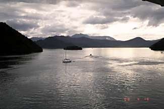
It was a
beautiful trip through the Sound. After
we pulled out into the strait, it was a forbidding rocky, mountainous shore
looking back and not obvious there was an entrance other than the fact we just
left one. Looking to the North Island
was a somewhat similar view although much more obvious where the entrance to
the Wellington Harbor must be.
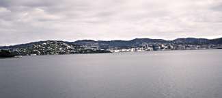
Initially, part of Wellington came into view with houses on the side of
a hill but we had to pull in much further and around a hill before Wellington
proper came into view.
Soon it
was time to retrieve my bike but I had difficulty finding the bottom level
where the rail cars were until a crewman pointed out the way. I was off the ferry quickly but then had to
find my way downtown to find a backpacker.
I had a list of backpackers I was going to call to find a single room
but never saw a phone so I decided to head to the City Lodge that had the most
single rooms and seemed the most likely candidate. When I finally found the place, I was able to get a single for
$25 but only for one night. They put me
on a wait list but told me it wasn’t too likely anyone would cancel since
singles were in demand. They also gave
me a list of other backpackers in case I wanted to call around.
Of
course, my room was on the top (3rd) floor but an elevator made easy
work of hauling my gear up including my bike.
What wasn’t so good was my room faced a very busy street so maybe it was
good I wouldn’t be staying long. After
I settled in, I gathered my clothes and put them in the washer. While waiting for the wash, I started
calling the backpacker list and the second one said they had room that I was
all set to take until the proprietor mentioned it had its own bath. That jogged me to ask the price, $65, and
that tipped me off that it wasn’t a backpacker room. A few more calls and I got a backpacker room for $25 a night for
the rest of my stay. Then I took my
clothes and fashioned a clothesline in back with a rope I had. There I hung my clothes to dry.
Then I
headed a few blocks away to Cuba Street, an eclectic mix of cafes, restaurants,
and shops. I also knew it had a
barbershop from a business card I found in the backpacker. I headed there so I could get my overgrown
beard trimmed. The trim cost me all of
$5 and I looked like a new man.
Further
down the street I found a cyber café with real Internet PCs and took care of
email. After further wandering, I
stopped in a Turkish place and ordered their lasagne and garlic bread. The bread was good but their idea of lasagne
was noodles and ground beef. Not bad but not lasagne.
Then I
walked back to the backpacker and collected my laundry that was mostly dry
except for my bike shorts as usual.
Then I took off to locate my other backpacker that was roughly a half
dozen blocks south of my current one.
But my experience in NZ is that locating isn’t always
straightforward. Often street signs are
missing or hard to find. Addresses are
also quite often missing, make it hard to zero in on an address. Today I learned addresses aren’t even
consistent from street to street. My
backpacker was a 150 address but a few blocks away the addresses were 100 less
(e.g., 50) on a street where I could not find a street sign. Eventually I found my address a few more
blocks away. While further from the
downtown it was also a quiet part of town.
On my
way back, I couldn’t help but be impressed by the diversity of food
choices. There was Malaysian,
Vietnamese, Cambodian, Indian, Turkish, Japanese, and others except for
American. Back home, I collected my
drink coupon and retired to the backpacker bar for a $2 pint of beer and wrote
my notes.
![]()

![]()
Copyright
Denis Kertz, 2000. All rights reserved.