Southern Pacific Crest
Trail &
Fall 2010
Denis Kertz, ©2010
Day 20: Sat, Sep 25, 2010 - Palmdale , CA to Apple
Valley , CA
I ate breakfast at the same diner across the street and had whole wheat pancakes, which was nice for a change. I didn't get off until almost 9am.
My destination for
the day was
The big question was how hot it would get. It was already comfortably warm at 9am. There were a few places to stop for food/water early but then there was nothing until the end. I stopped at Pearblossom for my second breakfast and that was the last service until near the end.
Eventually 138 turned southeast but 18 split off to the east and I took 18. Road conditions were still good until I hit the county line and then the good shoulder was history. The new shoulder was about a foot wide with cracks in it. This would turn out to be an issue later.
The real problem with the very warm temperature was my drinking water was warm too and not satisfying. I sucked on some hard candy and that helped some but there's no replacement for a cold drink and I spent much of my time dreaming of my next cold drink.
About 10 miles from Victorville I was surprised to see a red car pass me and then immediately pull over on the shoulder followed by a white SUV that pulled behind the car. That made no sense but I guessed that the parties needed to confer with each other about their route but it was very strange that they chose that location. About 20 minutes later or so the white SUV pulled along side me at a light and the driver said something about I had caused an accident and he needed to talk to me. Right after the intersection he pulled over and I stopped. He said that earlier the red car had stopped abruptly to keep from hitting me and he had bumped into the red car. So he wanted to collect my contact information which I gave him. He seemed to think that the red car was at fault for stopping suddenly but my guess is the guy will be found at fault. This guy said there were some road undulations and he figured the woman in the red car did not see me until the last minute when coming over an undulation and then perhaps did a panic stop. Otherwise I have no idea why she would think she was going to hit me. People all afternoon had managed to avoid me despite the narrow shoulder. At least it looked like it was just minor bumper contact from what I could see although perhaps there was more damage on the red car’s rear end.
As I continued counting down the miles to Victorville and a cold drink I was surprised to see some services at an intersection ahead. This was the intersection with 395 that I hadn't noticed on the map. This particular Arco station had my lemon-lime Gatorade as a selection at the soda fountain and I downed a 32oz. A few miles later I saw another Arco station so I repeated the process.
A few miles later I
rode into Victorville and continued riding until I picked up 18 again to
Overall, an easy day with just over 60 miles with very warm temperatures.
Day 21: Sun, Sep 26, 2010 - Apple
Valley , CA
I got on the road early and stopped at a Taco fast food place that served breakfast and had a decent 2+2+2.
My goal for the day
was Joshua Tree, over 60 miles away. The
main issue was the heat and whether there would be places to stop for cold
drinks along the way. My first stop was
Today's ride was more scenic than yesterday. It ran down the middle of a very wide desert valley with mountains on both sides. There was some climbing but nothing really major.
The day was a grind
without any place to stop, not even for some respite from the sun. I did eventually find a spot with some large
boulders where I was able to find a shady spot for a short rest. But the real problem was water – warm water. I had plenty of water. It's just that warm water doesn't seem to do
much good. I had hoped that a place
called
Finally, after nearly 50 miles I passed by a fire station and I stopped. I thought I might be able to get my water bottles refilled with something cool but I got something better. A guy gave me a cold water bottle from their refrigerator. Better yet, he told me there were a couple places to stop just a few miles down the road, which is what I really wanted to hear. I guzzled the cold water bottle and moved on.
A couple miles later after a short, steep climb I stopped at a food mart. First I drank a 32oz Gatorade which took about 4 gulps. Then I drank a 32oz soda from the soda fountain and nursed that a bit longer. Then I had to hang around a bit to allow my body to absorb all that liquid.
After about a 30
minute break I rode on feeling much better with only about 10 miles to go to
I stopped once more for another 32oz Gatorade in town and then headed to Joshua Tree, 6 miles up the road. The road was pretty awful with a rough shoulder. I rode through Joshua Tree to size up the place, whose existence is to provide services for folks coming from/to Joshua Tree National Park. After the pass through I backtracked to the High Desert Motel for a room at $49. It was an okay room that was next to a small restaurant and grocery store. I grabbed a hamburger meal and picked up a few things for tomorrow where I would be camping in the park.
Day 22: Mon, Sep 27, 2010 - Joshua Tree, CA to Joshua Tree NP, CA [59.2, 6:47:50, 8.7 mph, 2,506']
I got up early to
get off to a good start. I had a good
breakfast at the Crossroads Cafe with multigrain pancakes and bacon. Heading south from
The morning was
very scenic riding through the park. It
was easy to see how the park got its name.
There were Joshua Trees dotted all over the place.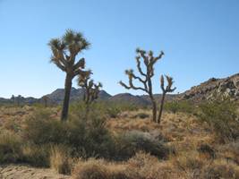 The Joshua Tree, which is not really a tree
but a yucca, was named by the Mormons due to its similarity to Joshua, from the
Bible, raising his hands up to the sky in prayer. There were also a lot of granite hunks that
had been carved into what looked like building blocks. Some of these granite hunks were climbing
places where the climbers went when the other places, such as
The Joshua Tree, which is not really a tree
but a yucca, was named by the Mormons due to its similarity to Joshua, from the
Bible, raising his hands up to the sky in prayer. There were also a lot of granite hunks that
had been carved into what looked like building blocks. Some of these granite hunks were climbing
places where the climbers went when the other places, such as
Stopping at most of
the turnouts and exhibits the morning was fairly slow but interesting
progress. After about 30 miles I came to
the intersection where I could head back to the highway or turn south to my
destination of Cottonwood Campground.
Southward bound led me through a steep descent through the
In contrast to the
morning which was reasonably pleasant temperature with a little cooling breeze
the descent was hot. I would have
thought the descent would be a little cooling but I could feel myself passing
through pockets of hot air. The descent
also took me from the high Mojave Desert of the northern part of the park to
the
I descended into
the wide open  There were some cholla cactus and ocotillos
near the bottom of the descent.
There were some cholla cactus and ocotillos
near the bottom of the descent.
All day I took care to keep myself well hydrated. The park recommended at least a gallon of water per day and 2 gallons for more strenuous activity. I had my usual 3 large 27oz water bottles and one 18oz water bottle plus a 2 liter water bag. I made sure I kept sipping on my water all day and not getting behind. That was just as well because my water kept getting hotter as the day heated up and it required some discipline to keep drinking warm/hot water. I ended the day with a large water bottle so everything worked out well hydration wise.
When descending the basin just looked flat. At one point there was a parking area with a trail sign with a little roof over that provided a patch of shade. Since shade was very difficult to come by, I stopped and sat under the shade while eating a banana and dreaming of a cold drink. When I resumed riding it wasn't long before I started climbing out of the flat basin.
Near 4pm I stopped at
the
I set my tent up quickly to provide some shade and did my best to feed my appetite with lukewarm water. Once the sun went down it became pleasant. I could only hope the temp would drop enough to provide some cool water by morning.
Day 23: Tue, Sep 28, 2010 - Joshua Tree NP, CA to Westmorland , CA
I was tired and went to sleep at 7pm last night. It was warm so I just laid on top of my sleeping bag and slept okay. Later in the morning it was finally cool enough that I put my bare legs in the sleeping bag.
When I woke up
around 6am it was cool and very cloudy.
Because of the clouds there was a spectacular sunrise behind the
mountains with the sky lit up in red. I
ate breakfast and packed up and left.
The campsite had 62 campsites and there were two couples from
It was all downhill
to I10, 7 miles away. Along the descent
I saw movement just off the road and thought it was deer but then I realized it
was big horn sheep. I stopped and walked
to the side a bit and saw 4 or 5 big horns bounding up the hill across the way. They watched me warily so I moved on after a
few minutes. The road looked pretty
level but it had to be fairly steep because I was coasting at 30 mph.
They watched me warily so I moved on after a
few minutes. The road looked pretty
level but it had to be fairly steep because I was coasting at 30 mph.
When I reached I10
I continued over the Interstate and picked up 
At the end of the
canyon I came upon a view of the
Then the fun
started. My destination was
Then it was a
matter of cranking out the miles on a flat road. The sun had started peeking behind the clouds
when I reached
After that the next
stop was
I continued on and
stopped in
I ended up stopping
at the police department, which I wish I had done initially, and asked about
accommodations. I got the word I would
have to either head back to
The lone motel was nice but on the expensive side at $80. Fortunately, my AARP discount helped and the place also had a continental breakfast. After cleaning up I walked to a steak place with the only other option a Mexican burrito place. I had my first beer of the trip since I ate at the bar and that first cold beer went down really quickly and I knew I couldn't continue that. I had a grilled chicken meal that was really good and a lot of food.
So the day was a
surprise in many respects. The ride
through
Day 24: Wed, Sep 29, 2010 - Westmorland , CA to El Centro ,
CA
I wasn't in any
great hurry to leave quickly other than to beat the heat which was projected to
reach 100F. The motel had a rather
mediocre continental breakfast but I took advantage of it nevertheless. Because of yesterday's long ride, I only had
22 miles to
I simply rode 86
all the way to
The ride was pretty boring – a flat ride through a big agricultural area. I did start the day at 178 feet below sea level and ended above sea level but the “climbing” was virtually unnoticeable.
When I rode into
I spent a fair
amount of time thinking about different options for my
Anyway I managed
enough research that I figured I could make a decision when I reached
The big deal with
tomorrow is that it was 60 miles to
Day 25: Thu, Sep 30, 2010 - El Centro , CA to Casa
Grande , AZ
With the temp
expected to hit over 100 I wanted as early a start as possible to get to
I headed north
about a mile to catch the road to Holtville that would eventually bend back to
I8 where I would be forced to ride I8 most of the rest of the way. Holtville was 10 miles away and the first
half was a bad road with lots of cracks.
After the intersection with 111 the road was fine the rest of the
way. I didn't really need a drink when I
reach Holtville but it was the last chance for any drink until near
The morning turned out to be favorable for me. There was some cloud cover and some small standing water suggested it had rained at least a bit overnight. The cloud cover kept the sun at bay until about 9am but even after that there was spotty cloud cover that kept the sun from hammering down for long periods of time.
Riding an
Interstate isn't much fun but at least this one had fairly moderate traffic. I brought extra water for the trip and forced
myself to start drinking early to make sure I kept myself hydrated. There wasn't much to do but grind out the
miles. The other thing to do was
consider my options when I reached
I brought extra water for the trip and forced
myself to start drinking early to make sure I kept myself hydrated. There wasn't much to do but grind out the
miles. The other thing to do was
consider my options when I reached
So I figured it was
best to skip the
I made good time
riding to 
This last road was
well located. It brought me into
After that I headed
east and then south on Pacific to get to the
So within two hours
of arriving in
Nevertheless I made it out of town without incident. Right away there was some awesome mountain scenery heading east. The Interstate passed right through the mountains but in the blink of an eye they were gone. That reminded me why bicycle travel is so good. You can't just pass through in the blink of an eye unless you are going down a steep downhill. And you can stop at almost any time to admire the scenery further or take photos. With a vehicle that is rarely true.
I headed east on I8
towards
Eventually I had to
decide on today's destination. I could
have made
The motel wasn't well situated for walking to food sources so I ate at the fast food drive in across the street which looked like the only real option, assuming I didn't want to eat at the Holiday Inn bar/grill next door.
![]()

![]()
Copyright
Denis Kertz, 2010. All rights reserved.